|
Barcode
4687820500982
Title
South-East Atlantic Ocean
Contributor
[Albernaz, João Teixeira, fl. 1602-1649, cartographer, Berry, Marie-Caroline de Bourbon-Sicile, duchesse de, 1798-1870, former owner, Aunay, Jean-Charles de Mesgrigny d', comte, 1680-1763, former owner]
Type
Manuscripts
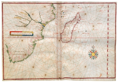
Barcode
4687820500971
Title
South West Indian Ocean and South East Atlantic Ocean
Contributor
[Albernaz, João Teixeira, fl. 1602-1649, cartographer, Berry, Marie-Caroline de Bourbon-Sicile, duchesse de, 1798-1870, former owner, Aunay, Jean-Charles de Mesgrigny d', comte, 1680-1763, former owner]
Type
Manuscripts
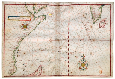
Barcode
4687820500984
Title
West Indian Ocean
Contributor
[Albernaz, João Teixeira, fl. 1602-1649, cartographer, Berry, Marie-Caroline de Bourbon-Sicile, duchesse de, 1798-1870, former owner, Aunay, Jean-Charles de Mesgrigny d', comte, 1680-1763, former owner]
Type
Manuscripts
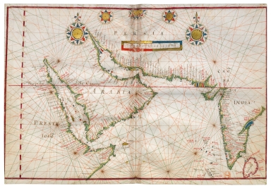
Barcode
4687820500983
Title
Northwest Indian Ocean
Contributor
[Albernaz, João Teixeira, fl. 1602-1649, cartographer, Berry, Marie-Caroline de Bourbon-Sicile, duchesse de, 1798-1870, former owner, Aunay, Jean-Charles de Mesgrigny d', comte, 1680-1763, former owner]
Type
Manuscripts
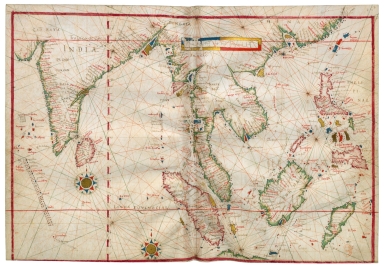
Barcode
4687820500981
Title
East Indian Ocean and China Sea
Contributor
Albernaz, João Teixeira, fl. 1602-1649, cartographer
Type
Manuscripts
Barcode
4687820500985
Title
China Sea and West Pacific Ocean
Contributor
[Albernaz, João Teixeira, fl. 1602-1649, cartographer, Berry, Marie-Caroline de Bourbon-Sicile, duchesse de, 1798-1870, former owner, Aunay, Jean-Charles de Mesgrigny d', comte, 1680-1763, former owner]
Type
Manuscripts
Barcode
4687820500980
Title
West Pacific Ocean
Contributor
[Albernaz, João Teixeira, fl. 1602-1649, cartographer, Berry, Marie-Caroline de Bourbon-Sicile, duchesse de, 1798-1870, former owner, Aunay, Jean-Charles de Mesgrigny d', comte, 1680-1763, former owner]
Type
Manuscripts
Barcode
4687820500974
Title
Northeast Pacific Ocean
Contributor
[Albernaz, João Teixeira, fl. 1602-1649, cartographer, Berry, Marie-Caroline de Bourbon-Sicile, duchesse de, 1798-1870, former owner, Aunay, Jean-Charles de Mesgrigny d', comte, 1680-1763, former owner]
Type
Manuscripts
Barcode
4687820500970
Title
Southeast Pacific Ocean
Contributor
[Albernaz, João Teixeira, fl. 1602-1649, cartographer, Berry, Marie-Caroline de Bourbon-Sicile, duchesse de, 1798-1870, former owner, Aunay, Jean-Charles de Mesgrigny d', comte, 1680-1763, former owner]
Type
Manuscripts
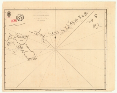
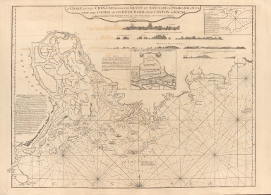
Barcode
4687820501093
Title
Neat outline of the Beijing river in China located in the Indian Sea
Type
Manuscripts
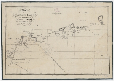
Barcode
4687820500373
Title
Chart of the coast of China to the eastward of the great Ladrone
Contributor
[Ross, Daniel, 1780-1849, cartographer, Horsburgh, James, 1762-1836, publisher]
Type
Printed
Barcode
4687820501008
Title
Carte des Isles de Lieou-Kieou dont le roi est tributaire de la Chine : Cette Carte est l'ouvrage du P. Gaubil, envoyée à M. L'Abbé Sallier qui l'a reçue en 1752, et me la communiquée aussitôt.
Contributor
[Gaubil, Antoine, 1689-1759, bibliographic antecedent, Sallier, Claude, 1685-1761, correspondent]
Type
Manuscripts
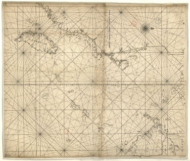
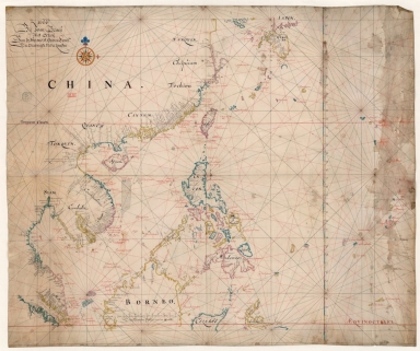
Barcode
4687820500914
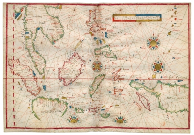
Title
[East Indies, including a large "Java Maior" (Australia?) and coast of Asia]
Contributor
[Oliva, Bartolomeo, 1538-1588, cartographer, Phillipps, Thomas, Sir, 1792-1872, former owner]
Type
Manuscripts
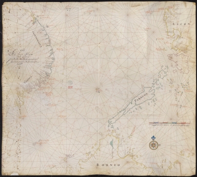
Barcode
4687820500849
Title
[Carta náutica de Macau e das ilhas de Cantão]
Contributor
Anonymous
Type
Manuscripts
Barcode
4687820500010
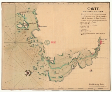
Title
Carte de l'entrée de la riviere de Canton dans la Chine
Contributor
Bellin, Jacques-Nicolas, 1703-1772, cartographer
Type
Printed
Barcode
4687820500008
Title
Carte des Isles qui sont a l'entrée de la riviere de Canton
Contributor
Bellin, Jacques-Nicolas, 1703-1772, cartographer
Type
Printed
Barcode
4687820500123
Title
Carte du port de Goa et ses environs
Contributor
Bellin, Jacques-Nicolas, 1703-1772, cartographer
Type
Printed
Barcode
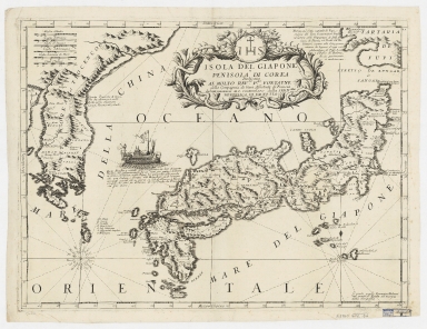
4687820500326
Title
Isola del Giappone e penisola di Corea
Contributor
[Coronelli, Vincenzo, 1650-1718, cartographer, Padoani, Domenico, fl. 16--, printer, bookseller, Fontaine, Paolo, dedicatee]
Type
Printed
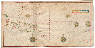
Barcode
4687820501013
Title
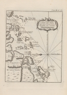
[Observations publiées en 1646-1648 par Robert Dudley, Atlantique, Méditerranée, Océan Indien, Mer de Chine]
Contributor
[Delisle, Guillaume, 1675-1726, cartographer, Dudley, Robert, Sir, 1574-1649, bibliographic antecedent]
Type
Manuscripts
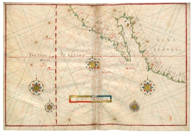
Barcode
36878003545017
Title
[Carte française de la Mer de Chine et du Golfe de Siam]
Type
Manuscripts
Barcode
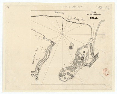
4687820501168
Title
Plan de la ville et des environs de Macao
Contributor
Dupont, Paul-François, 1796-1879, lithographer
Type
Manuscripts
Barcode
3687800354505B
Title
Chart of the southern coasts of the Islands between S.t Johns and the Ladrone taken on board the Nassau, Capt. Arthur Gore, and inscribed to Nathaniel Smith Esq.r
Contributor
[Larkins, John Pascal, 17---1794, cartographer, Dalrymple, Alexander, 1737-1808, publisher, Harrison, William, ca. 1750-1803, engraver, Smith, Nathaniel, 1730-1794, dedicatee]
Type
Printed
Barcode
3687800354504A
Title
Chart of the south coast of China from Macao to The Brothers
Contributor
[Inverarity, David, 17---18--, cartographer, Dalrymple, Alexander, 1737-1808, editor, publisher, Harmer, Thomas, fl. 1784-1814, engraver]
Type
Printed
Barcode
3687800354506C
Title
Map of the China Sea
Contributor
Blaeu, Joan, 1596-1673, cartographer
Type
Manuscripts
Barcode
3687800354513A
Title
Map of the coast of China and part of Formosa Island between 2.d and 30.d 30.m north latitude
Type
Manuscripts
Barcode
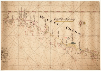
36878003545129
Title
De Cust China
Type
Manuscripts
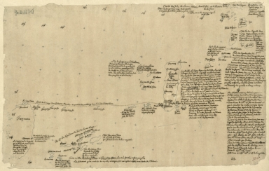
Barcode
3687800354089I
Title
[World chart]
Contributor
[Brouscon, Guillaume, fl. 15--, cartographer, Cossé, Artus de, 1512-1582, former owner]
Type
Manuscripts
Barcode
3687800354090A
Title
[Planisphère]
Contributor
Teixeira, Domingos, fl. 1565-1595, cartographer
Type
Manuscripts
Barcode
3687800354085E
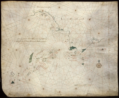
Title
[Portolan chart]
Type
Manuscripts
Barcode
3687800354088H
Title
[Southeast China, Japan, East Indies (northern part)]
Contributor
[Dourado, Fernão Vaz, 1520-1580, cartographer, Huth, Henry, 1815–1878, former owner]
Type
Manuscripts
Barcode
3687800285591J
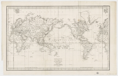
Title
Mappemonde ou Carte réduite des parties connues du globe pour servir au voyage de La Pérouse, fait dans les années 1785, 86, 87, et 88.
Contributor
[La Pérouse, Jean-François de Galaup, comte de, 1741-1788, cartographer, Imprimerie de la République (France), 1795-1804, printer]
Type
Printed
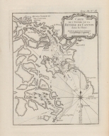
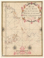
Barcode
36878003541248
Title
Plan de la riviere de Canton, Macao, et autres isles circonvoisines
Contributor
Liébaut, 16---17--, catographer
Type
Manuscripts
Barcode
3687800239892M
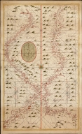
Title
[Asia]
Contributor
Albernaz, João Teixeira, fl. 1602-1649, cartographer
Type
Manuscripts
Barcode
36878003541204
Title
Plan et carte particuliere de la riviere de Cantong et ses environs et depuis l'isle de Sancien jusque a celle de Makao
Contributor
La Grange-Chancel, Louis de, 1678-1747, cartographer
Type
Manuscripts
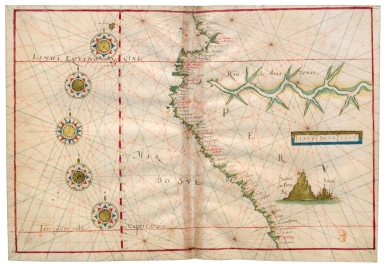
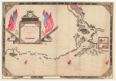
Barcode
4687820501101
Title
Carte plate d'une partie de la coste de Chine, depuis les isles Pulo-Taya au nord est de l'isle de Haynam, et toutes les isles tant de la la partie de l'ouest que celles de l'e[st] servant de reconnoissance pour l'entrée de la rivière de Canton
Contributor
Dauge, Philippe
Type
Manuscripts
Barcode
4687820501208
Title
Plan de la rivière de Canton dans la Chinne dans la partie du nord
Contributor
Anonymous
Type
Manuscripts
Barcode
4687820501205
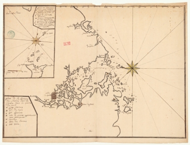
Title
Carte de l'entrée de Canton où sont marquez exactement tous les mouillages, que nous fismes depuis l'isle de Sanciam, les bancs, les roches et autres dangers que j'ay pu reconnoître
Contributor
Anonymous
Type
Manuscripts
Barcode
4687820501199
Title
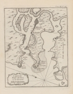
Carte de la rivière de Canton et de ses environs du costé du sud est [corrigé :] ouest
Type
Manuscripts
Barcode
4687820501072
Title
De Eӯlanden van Macaoủ, loopende van, t’Eӯlandt S.t Jủan totaande Stadt Canton
Contributor
De Graaf, Isaac, 1667-1743
Type
Manuscripts
Barcode
4687820501102
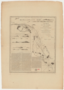
Title
A survey of the Tigris from Canton to the island of Lankeet
Contributor
Huddart, Joseph, 1741-1816
Type
Printed
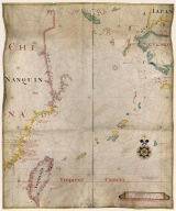
Barcode
4687820500576
Title
[Tonquin, Quancy, Aynam]
Contributor
[Hacke, William, fl. 16--, cartographer, Sharpe, Bartholomew, fl. 1679-1682, author]
Type
Manuscripts
Barcode
687800354127B
Title
A chart of the China Sea from the Island of Sanciam to Pedra Branca with the course of the River Tigris from Canton to Macao
Contributor
[Après de Mannevillette, Jean-Baptiste-Nicolas-Denis d', 1707-1780, cartographer, Larkins, John Pascal, 17---1794, author, bibliographic antecedent, Anson, George Anson, baron, 1697-1762, author, Huddart, Joseph, 1741-1816, bibliographic antecedent]
Type
Printed
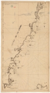
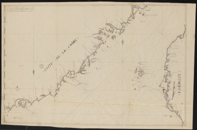
Barcode
3687800354261A
Title
Carte de côte de la Chine depuis les 22.e jusqu'au 25.e 30.m de latitude nord comprenant la partie de Ouest de l'Isle Formose
Type
Manuscripts
Barcode
3687800354567J
Title
[Chart of the Sea of Canton to Cambodia and the Philippines]
Type
Manuscripts
Barcode
3687800354509F
Title
Map of the coasts of China and neighboring islands with some additions
Contributor
Anville, Jean Baptiste Bourguignon d', 1697-1782, cartographer
Type
Printed
Barcode
3687800354508E
Title
Map of the coasts of China and neighboring islands with some additions
Contributor
Anville, Jean Baptiste Bourguignon d', 1697-1782, cartographer
Type
Manuscripts
Barcode
3687800317478J
Title
Dutch nautical chart of the 18th century, including the coasts of Annam, Tonkin, China, Hainan Island and part of Luzon
Contributor
Saffroy, Amand, 1844-1905, former owner
Type
Manuscripts
Barcode
3687800354255D
Title
Map of the South China Sea
Contributor
Blaeu, Joan, 1596-1673, cartographer
Type
Manuscripts
Barcode
3687800354308C
Title
Gulf of Tonkin to Luzon and Formosa
Contributor
Thornton, John, 1641-1708, hydrographer
Type
Manuscripts
|
![[East Indies, including a large "Java Maior" (Australia?) and coast of Asia]](http://lunamap.must.edu.mo:80/MediaManager/srvr?mediafile=/Size2/MUST~2~2/45/000358.jpg)
![[Carta náutica de Macau e das ilhas de Cantão]](http://lunamap.must.edu.mo:80/MediaManager/srvr?mediafile=/Size2/MUST~2~2/46/D89r.jpg)
![[Observations publiées en 1646-1648 par Robert Dudley, Atlantique, Méditerranée, Océan Indien, Mer de Chine]](http://lunamap.must.edu.mo:80/MediaManager/srvr?mediafile=/Size2/MUST~2~2/54/ge+sh+18+pf+1+div+0+p+10-4.jpg)
![[Carte française de la Mer de Chine et du Golfe de Siam]](http://lunamap.must.edu.mo:80/MediaManager/srvr?mediafile=/Size1/MUST~2~2/63/GE+SH+18+PF+181+P+9+RES+-+Carte+fran%C3%83%C2%A7aise+de+la+Mer+de+Chine+et+du+Golfe+de+Siam.jpg)
![[World chart]](http://lunamap.must.edu.mo:80/MediaManager/srvr?mediafile=/Size2/MUST~2~2/45/000502.jpg)
![[Planisphère]](http://lunamap.must.edu.mo:80/MediaManager/srvr?mediafile=/Size2/MUST~2~2/54/GE+SH+ARCH-3.jpg)
![[Portolan chart]](http://lunamap.must.edu.mo:80/MediaManager/srvr?mediafile=/Size2/MUST~2~2/45/000651.jpg)
![[Southeast China, Japan, East Indies (northern part)]](http://lunamap.must.edu.mo:80/MediaManager/srvr?mediafile=/Size2/MUST~2~2/45/000434.jpg)
![[Asia]](http://lunamap.must.edu.mo:80/MediaManager/srvr?mediafile=/Size2/MUST~2~2/41/G1015+.T4+1630-12.jpg)
![Carte plate d'une partie de la coste de Chine, depuis les isles Pulo-Taya au nord est de l'isle de Haynam, et toutes les isles tant de la la partie de l'ouest que celles de l'e[st] servant de reconnoissance pour l'entrée de la rivière de Canton](http://lunamap.must.edu.mo:80/MediaManager/srvr?mediafile=/Size2/MUST~2~2/54/GE+SH+18+PF+179+DIV+9+P+9+-+Carte+plate+d%27une+partie+de+la+coste+de+Chine.jpg)
![Carte de la rivière de Canton et de ses environs du costé du sud est [corrigé :] ouest](http://lunamap.must.edu.mo:80/MediaManager/srvr?mediafile=/Size2/MUST~2~2/63/GE+SH+18+PF+179+DIV+9+P+131+D+-+Carte+de+la+rivi%C3%83%C2%A8re+de+Canton+-+sud+est.jpg)
![[Tonquin, Quancy, Aynam]](http://lunamap.must.edu.mo:80/MediaManager/srvr?mediafile=/Size2/MUST~2~2/33/G2201.P5+H3+1690.jpg)
![[Chart of the Sea of Canton to Cambodia and the Philippines]](http://lunamap.must.edu.mo:80/MediaManager/srvr?mediafile=/Size2/MUST~2~2/54/GE+SH+18+PF+181+P+21+RES+Carte+des+mers+de+Canton.jpg)