|
Barcode
4687820500622
Title
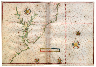
Carta Universal en que se contiene todo lo que del mundo se ha descubierto fasta agora / hizola Diego Ribero cosmographo de Su magestad, Anõ de 1529. e[n] Sevilla. La qual se devide en dos partes conforme ala capitulaçion que hizieron los catholicos Reyes de españa [y] el Rey don Juan de portogual en Tordesillas, Anõ de 1494.
Contributor
[Ribeiro, Diogo, fl. 1519-1533, cartographer, Griggs, William, 1832-1911]
Type
Printed
Barcode
4687820500658
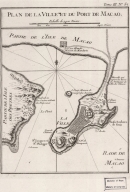
Title
Plan de la ville et du port de Macao
Contributor
Bellin, Jacques-Nicolas, 1703-1772, cartographer
Type
Printed
Barcode
4687820500498
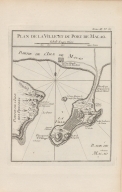
Title
Plan de la ville et du port de Macao
Contributor
Bellin, Jacques-Nicolas, 1703-1772, cartographer
Type
Printed
Barcode
4687820500710
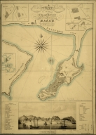
Title
A map of the city and harbour of Macao
Contributor
Bramston, William, 17---18--, author
Type
Printed
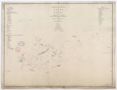
Barcode
4687820500105
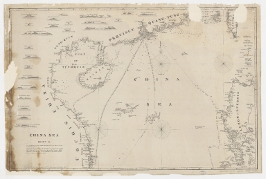
Title
China Sea. Sheet II
Contributor
Horsburgh, James, 1762-1836, cartographer, publisher
Type
Printed
Barcode
4687820500050
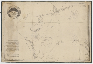
Title
China Sea. Sheet 1.st to James Drummond Esquire in acknowledgement for his laudable endeavours towards perfecting the navigation of the China Sea
Contributor
[Horsburgh, James, 1762-1836, cartographer, publisher, James Drummond, 8th Viscount Strathallan, 1767-1851, dedicatee]
Type
Printed
Barcode
4687820500260
Title
A chart of the China Sea, and Philippine Islands with the Archipelagos of Felicia and Soloo : shewing the whole tract comprized, between Canton and Balambangan, with the soundings, shoals, rocks, & ca.
Contributor
Whittle & Laurie, publisher
Type
Printed
Barcode
4687820501012
Title
[Indian Ocean from the Cape of Good Hope to Banda and from the Black Sea to Japan, Arabia, Persia, India, Indo-china and Insulinde, South China, Japan]
Contributor
Angelus, author
Type
Manuscripts
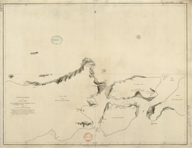
Barcode
4687820500255
Title
A chart of the south coast of Hay-nan, from Tinhosa to Guichou
Contributor
[Haldane, John, captain, fl. 177-, cartographer, Laurie & Whittle, publisher]
Type
Printed
Barcode
4687820500370
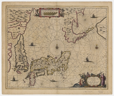
Title
Nova et accurata Japoniae, terrae Esonis ac insularum adjacentium ex novissimâ detectione descriptio.
Contributor
Jansson, Jan, 1588-1664, printer
Type
Printed
Barcode
4687820501085
Title
[Carte nautique de l'Océan Atlantique, d'une partie de l'Océan Indien et d'une partie de l'Océan Pacifique]
Contributor
Lasso, Bartolomeu, fl. 1564-1590, dubious author
Type
Manuscripts
Barcode
4687820501190
Title
[Carte des Mers de Java jusqu'à Canton]
Contributor
Robert
Type
Manuscripts
Barcode
4687820501260
Title
[Vues de cotes des mers de Chine]. 1.er
Contributor
Surville, Jean-François de, 1717-1770, author
Type
Manuscripts
Barcode
4687820501261
Title
[Vues de cotes des mers de Chine]. 2.e
Contributor
Surville, Jean-François de, 1717-1770, author
Type
Manuscripts
Barcode
4687820501262
Title
[Vues de cotes des mers de Chine]. 3.º
Contributor
Surville, Jean-François de, 1717-1770, author
Type
Manuscripts
Barcode
4687820501267
Title
[Vues de cotes des mers de Chine]. 5.e
Contributor
Surville, Jean-François de, 1717-1770, author
Type
Manuscripts
Barcode
4687820501263
Title
[Vues de cotes des mers de Chine]. 4.e
Contributor
Surville, Jean-François de, 1717-1770, author
Type
Manuscripts
Barcode
4687820501266
Title
[Vues de cotes des mers de Chine]. 7.e
Contributor
Surville, Jean-François de, 1717-1770, author
Type
Manuscripts
Barcode
4687820501264
Title
[Vues de cotes des mers de Chine]. 8.e
Contributor
Surville, Jean-François de, 1717-1770, author
Type
Manuscripts
Barcode
4687820501265
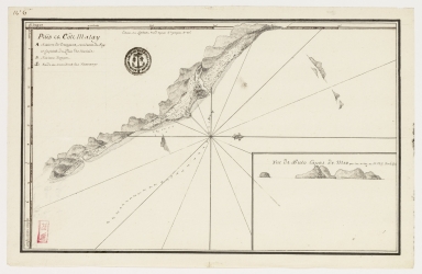
Title
Païs et côte Malay
Contributor
Surville, Jean-François de, 1717-1770, cartographer
Type
Manuscripts
Barcode
4687820500218
Title
A chart of the China Sea : inscribed to Mons.r D'Aprés de Mannevillette the ingenious author of the Neptune Oriental, as a tribute due to his labours for the benefit of Navigation, and in acknowledgement of his many signal favours to Dalrymple.
Contributor
[Dalrymple, Alexander, 1737-1808, hydrographer, Demonville, Antoine Guénard, ca. 1733-1797, printer, Malassis, Romain-Nicolas, 1737-1813, printer, Après de Mannevillette, Jean-Baptiste-Nicolas-Denis d', 1707-1780, dedicatee]
Type
Printed
Barcode
4687820501174
Title
Carte d'une partie de la mer de Chine
Contributor
Rosili Mesros, François Etienne de, 1748-1832, bibliographic antecedent
Type
Printed
Barcode
3687800354286H
Title
[Carte d'une partie de la mer de Chine]
Type
Manuscripts
Barcode
3687800354287I
Title
To the Honorable the Court of Directors of the United Company of Merchants of England trading to the East Indies, this Chart of the China Seas
Contributor
[Heather, William, 1764-1812, hydrographer, Stephenson, John,, fl. 1791-1817, engraver, Norie, John William, 1772-1843, illustrator, Heather and Williams, publisher]
Type
Printed
Barcode
3687800354289K
Title
To the Honorable the Court of Directors of the United Company of Merchants of England trading to the East Indies, this Chart of the China Seas
Contributor
[Heather, William, 1764-1812, hydrographer, Stephenson, John,, fl. 1791-1817, engraver, Norie, John William, 1772-1843, illustrator, Heather and Williams, publisher]
Type
Printed
Barcode
4687820500336
Title
A new chart of the China Sea, with its several entrances : drawn from a great number of draughts, journals, and other National documents, regulated by astronomical observations
Contributor
[Laurie & Whittle, author, publisher, Larkins, John Pascal, 17---1794, cartographer, Rees, Captain, cartographer]
Type
Printed
Barcode
3687800354267G
Title
A new chart of the China Sea, with its several entrances : drawn from a great number of draughts, journals, and other National documents, regulated by astronomical observation
Contributor
[Laurie & Whittle, author, publisher, Larkins, John Pascal, 17---1794, cartographer, Rees, Captain, cartographer]
Type
Printed
Barcode
4687820501172
Title
[Route de M. de Richery en 1787 de Pondichery a Canton]
Type
Manuscripts
Barcode
4687820501071
Title
Seconde partie de la carte d'Asie : contenant la Chine, et partie de la Tartarie, l'Inde au delà du Gange, les Isles Sumatra, Java, Borneo, Moluques, Philippines et du Japon. Publiée sous les auspices de Monseigneur Louis-Philippe D'Orléans, Duc D'Orléans, prémier Prince du Sang
Contributor
Anville, Jean Baptiste Bourguignon d', 1697-1782, cartographer
Type
Manuscripts
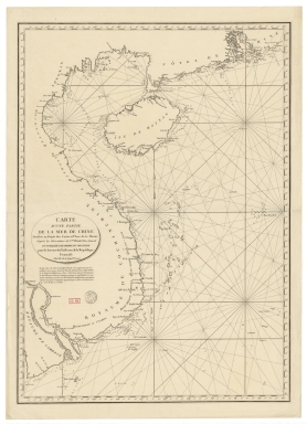
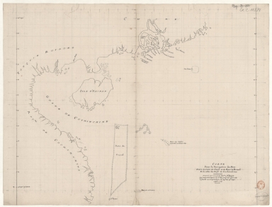
Barcode
4687820501015
Title
Carte pour la navigation des mers entre les cotes de Chine et du Blanc le Paracel et de celles du Golfe de Cochinchine : dressée sur une carte MS.te a M.r Bouvet qui contenoit depuis le 2.e deg. jusq.' 24.e dont cette 1.ere feuille ne comprend que du 24.e au 13.e degré.
Contributor
Bouvet, 16---17--, bibliographic antecedent
Type
Manuscripts
Barcode
4687820501075
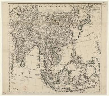
Title
Carte des Indes et de la Chine : dressée sur plusieurs relations particulières rectifiées par quelques observations
Contributor
[Delisle, Guillaume, 1675-1726, cartographer, publisher, Renard, Louis, ca. 1678-1746, publisher]
Type
Manuscripts
Barcode
4687820501177
Title
A chart of part of the coast of China, and the adjacent islands from Pedro Blanco to the Mizen : laid down from observations made in 1759 and 1760, in the Schooner Cuddalore, and in the Ship London, 1764
Contributor
[Dalrymple, Alexander, 1737-1808, hydrographer, publisher, Henry, B., fl. 1770-1775, engraver, Lerpinière, Daniel, 1745-1785, engraver, Whitchurch, William, fl. 18th century, engraver, Lane, Bartholomew, fl. 19th century, engraver]
Type
Printed
Barcode
4687820501171
Title
Chart of the Strait of Solor : from a Portuguese ms used by the Portuguese of Macao in the navigation to Timor
Contributor
[Harmer, Thomas, fl. 1784-1814, engraver, Dalrymple, Alexander, 1737-1808, publisher]
Type
Printed
Barcode
4687820501077
Title
Carte generale de la Chine : dressée sur les cartes particulieres que l'Empereur Cang-hi a fait lever sur les lieux par les RR. PP. Jesuites mission[n]aires dans cet Empire
Contributor
[Anville, Jean Baptiste Bourguignon d', 1697-1782, cartographer, Gravelot, Hubert-François, 1699-1773, illustrator, engraver, Delahaye, Jean Baptiste, fl. 1721-1723, engraver]
Type
Manuscripts
Barcode
4687820501030
Title
[Carte de l'Océan Indien, des cotes de l'Afrique et de l'Asie depuis le cap de Bonne-Espérance jusqu'au Japon]
Contributor
Albernaz, João Teixeira, fl. 1602-1649, cartographer
Type
Manuscripts
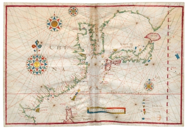
Barcode
4687820501007
Title
[[Carte portugaise de la mer des Indes entre le Cap de Bonne Espérance et le Cap Comorin] ; [Carte portugaise de la mer qui comprend le Golfe du bengale, les côtes de la Chine et les îles du Japon, Philippines, de la Sonde et Moluques], [Carte portugaise de la mer qui comprend le Golfe du bengale, les côtes de la Chine et les îles du Japon, Philippines, de la Sonde et Moluques]]
Contributor
Albernaz, João Teixeira, fl. 1602-1649, cartographer
Type
Printed
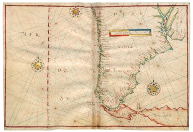
Barcode
4687820501029
Title
[[Carte portugaise de la mer des Indes entre le Cap de Bonne Espérance et le Cap Comorin] ; [Carte portugaise de la mer qui comprend le Golfe du bengale, les côtes de la Chine et les îles du Japon, Philippines, de la Sonde et Moluques], [Carte portugaise de la mer des Indes entre le Cap de Bonne Espérance et le Cap Comorin]]
Contributor
Albernaz, João Teixeira, fl. 1602-1649, cartographer
Type
Printed
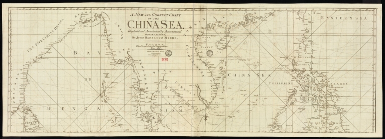
Barcode
4687820501178
Title
A new and correct chart of the China Sea
Contributor
[Moore, John Hamilton, 1738-1807, cartographer, Blake, T. J., fl. 1785-1785, engraver]
Type
Printed
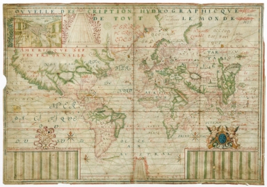
Barcode
4687820501183
Title
Nouvelle description hydrographique de tout le monde
Contributor
[Guérard, Jean, 15---1640, cartographer, Lauzon, Jean de, 1584-1666, dedicatee]
Type
Manuscripts
Barcode
4687820500976
Title
North China Sea and West Pacific Ocean
Contributor
Albernaz, João Teixeira, fl. 1602-1649, cartographer
Type
Manuscripts
Barcode
4687820500973
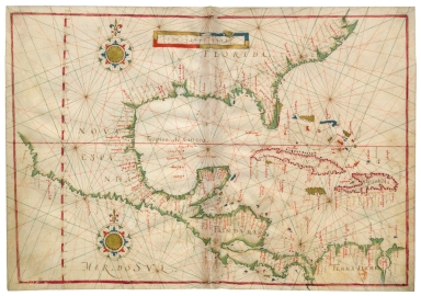
Title
Southeast Pacific Ocean and Southwest Atlantic Ocean
Contributor
[Albernaz, João Teixeira, fl. 1602-1649, cartographer, Berry, Marie-Caroline de Bourbon-Sicile, duchesse de, 1798-1870, former owner, Aunay, Jean-Charles de Mesgrigny d', comte, 1680-1763, former owner]
Type
Manuscripts
Barcode
4687820500972
Title
East Pacific Ocean and West Atlantic Ocean
Contributor
[Albernaz, João Teixeira, fl. 1602-1649, cartographer, Berry, Marie-Caroline de Bourbon-Sicile, duchesse de, 1798-1870, former owner, Aunay, Jean-Charles de Mesgrigny d', comte, 1680-1763, former owner]
Type
Manuscripts
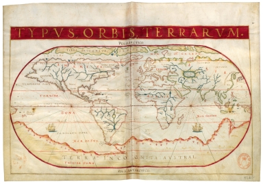
Barcode
4687820501001
Title
Typus Orbis Terrarum
Contributor
[Albernaz, João Teixeira, fl. 1602-1649, cartographer, Berry, Marie-Caroline de Bourbon-Sicile, duchesse de, 1798-1870, former owner, Aunay, Jean-Charles de Mesgrigny d', comte, 1680-1763, former owner]
Type
Manuscripts
Barcode
4687820500979
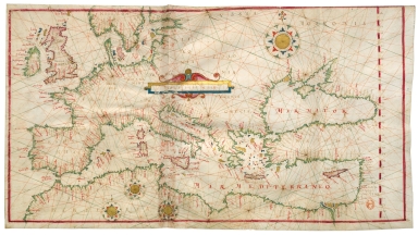
Title
North-East Atlantic Ocean, Mediterranean Sea and Black Sea
Contributor
[Albernaz, João Teixeira, fl. 1602-1649, cartographer, Berry, Marie-Caroline de Bourbon-Sicile, duchesse de, 1798-1870, former owner, Aunay, Jean-Charles de Mesgrigny d', comte, 1680-1763, former owner]
Type
Manuscripts
Barcode
4687820500978
Title
Eastern Atlantic Ocean and Western Mediterranean Sea
Contributor
[Albernaz, João Teixeira, fl. 1602-1649, cartographer, Berry, Marie-Caroline de Bourbon-Sicile, duchesse de, 1798-1870, former owner, Aunay, Jean-Charles de Mesgrigny d', comte, 1680-1763, former owner]
Type
Manuscripts
Barcode
4687820500975
Title
Northwest Atlantic Ocean
Contributor
[Albernaz, João Teixeira, fl. 1602-1649, cartographer, Berry, Marie-Caroline de Bourbon-Sicile, duchesse de, 1798-1870, former owner, Aunay, Jean-Charles de Mesgrigny d', comte, 1680-1763, former owner]
Type
Manuscripts
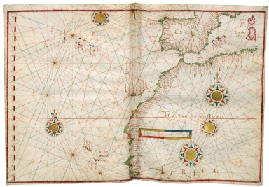
Barcode
4687820500968
Title
West Atlantic Ocean, Azores, Cape Verde Islands, Lesser Antilles
Contributor
[Albernaz, João Teixeira, fl. 1602-1649, cartographer, Berry, Marie-Caroline de Bourbon-Sicile, duchesse de, 1798-1870, former owner, Aunay, Jean-Charles de Mesgrigny d', comte, 1680-1763, former owner]
Type
Manuscripts
Barcode
4687820500977
Title
Eastern Atlantic Ocean
Contributor
[Albernaz, João Teixeira, fl. 1602-1649, cartographer, Berry, Marie-Caroline de Bourbon-Sicile, duchesse de, 1798-1870, former owner, Aunay, Jean-Charles de Mesgrigny d', comte, 1680-1763, former owner]
Type
Manuscripts
Barcode
4687820500967
Title
Central Atlantic Ocean
Contributor
[Albernaz, João Teixeira, fl. 1602-1649, cartographer, Berry, Marie-Caroline de Bourbon-Sicile, duchesse de, 1798-1870, former owner, Aunay, Jean-Charles de Mesgrigny d', comte, 1680-1763, former owner]
Type
Manuscripts
Barcode
4687820500969
Title
South West Atlantic Ocean
Contributor
[Albernaz, João Teixeira, fl. 1602-1649, cartographer, Berry, Marie-Caroline de Bourbon-Sicile, duchesse de, 1798-1870, former owner, Aunay, Jean-Charles de Mesgrigny d', comte, 1680-1763, former owner]
Type
Manuscripts
|
![Carta Universal en que se contiene todo lo que del mundo se ha descubierto fasta agora / hizola Diego Ribero cosmographo de Su magestad, Anõ de 1529. e[n] Sevilla. La qual se devide en dos partes conforme ala capitulaçion que hizieron los catholicos Reyes de españa [y] el Rey don Juan de portogual en Tordesillas, Anõ de 1494.](http://lunamap.must.edu.mo:80/MediaManager/srvr?mediafile=/Size3/MUST~2~2/30/G3200+1529+.R5+1887+MLC.jpg)
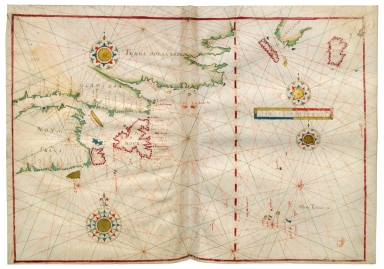
![[Indian Ocean from the Cape of Good Hope to Banda and from the Black Sea to Japan, Arabia, Persia, India, Indo-china and Insulinde, South China, Japan]](http://lunamap.must.edu.mo:80/MediaManager/srvr?mediafile=/Size2/MUST~2~2/54/FRANCAIS+9669+-+fol+8v-9.jpg)
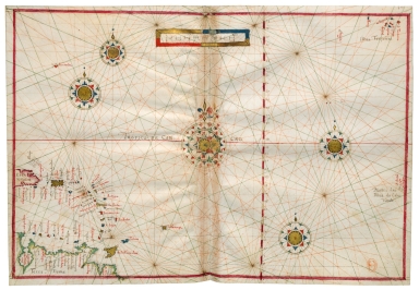
![[Carte nautique de l'Océan Atlantique, d'une partie de l'Océan Indien et d'une partie de l'Océan Pacifique]](http://lunamap.must.edu.mo:80/MediaManager/srvr?mediafile=/Size2/MUST~2~2/54/GE+B-1204%28RES%29.jpg)
![[Carte des Mers de Java jusqu'à Canton]](http://lunamap.must.edu.mo:80/MediaManager/srvr?mediafile=/Size1/MUST~2~2/54/GE+SH+18+PF+181+P+19+RES+Carte+des+Mers+de+Java.jpg)
![[Vues de cotes des mers de Chine]. 1.er](http://lunamap.must.edu.mo:80/MediaManager/srvr?mediafile=/Size1/MUST~2~2/54/GE+SH+18+PF+183+DIV+1+P+1+%28PL+1%29.jpg)
![[Vues de cotes des mers de Chine]. 2.e](http://lunamap.must.edu.mo:80/MediaManager/srvr?mediafile=/Size2/MUST~2~2/54/GE+SH+18+PF+183+DIV+1+P+1+%28PL+2%29.jpg)
![[Vues de cotes des mers de Chine]. 3.º](http://lunamap.must.edu.mo:80/MediaManager/srvr?mediafile=/Size1/MUST~2~2/54/GE+SH+18+PF+183+DIV+1+P+1+%28PL+3%29.jpg)
![[Vues de cotes des mers de Chine]. 5.e](http://lunamap.must.edu.mo:80/MediaManager/srvr?mediafile=/Size2/MUST~2~2/54/GE+SH+18+PF+183+DIV+1+P+1+%28PL5%29.jpg)
![[Vues de cotes des mers de Chine]. 4.e](http://lunamap.must.edu.mo:80/MediaManager/srvr?mediafile=/Size2/MUST~2~2/54/GE+SH+18+PF+183+DIV+1+P+1+%28PL4%29.jpg)
![[Vues de cotes des mers de Chine]. 7.e](http://lunamap.must.edu.mo:80/MediaManager/srvr?mediafile=/Size2/MUST~2~2/54/GE+SH+18+PF+183+DIV+1+P+1+%28PL7%29.jpg)
![[Vues de cotes des mers de Chine]. 8.e](http://lunamap.must.edu.mo:80/MediaManager/srvr?mediafile=/Size2/MUST~2~2/54/GE+SH+18+PF+183+DIV+1+P+1+%28PL8%29.jpg)

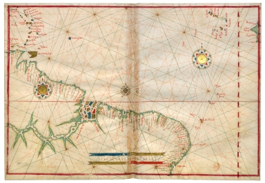
![[Carte d'une partie de la mer de Chine]](http://lunamap.must.edu.mo:80/MediaManager/srvr?mediafile=/Size2/MUST~2~2/54/GE+SH+18+PF+182+P+11+D_Carte+d%27une+partie+de+la+mer+de+Chine.jpg)


![[Route de M. de Richery en 1787 de Pondichery a Canton]](http://lunamap.must.edu.mo:80/MediaManager/srvr?mediafile=/Size2/MUST~2~2/54/GE+SH+18+PF+182+P+6+D_Routes+de+M+de+Richery+en+1787.jpg)

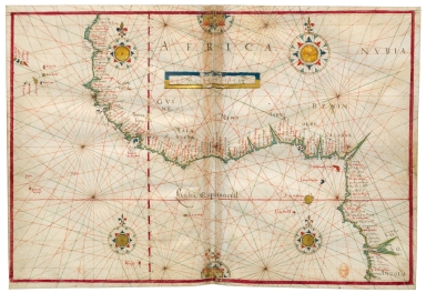
![Carte generale de la Chine : dressée sur les cartes particulieres que l'Empereur Cang-hi a fait lever sur les lieux par les RR. PP. Jesuites mission[n]aires dans cet Empire](http://lunamap.must.edu.mo:80/MediaManager/srvr?mediafile=/Size2/MUST~2~2/54/GE+C-8817.jpg)
![[Carte de l'Océan Indien, des cotes de l'Afrique et de l'Asie depuis le cap de Bonne-Espérance jusqu'au Japon]](http://lunamap.must.edu.mo:80/MediaManager/srvr?mediafile=/Size2/MUST~2~2/54/GE+SH+18+PF+213+DIV+3+P+2-2.jpg)
![[[Carte portugaise de la mer des Indes entre le Cap de Bonne Espérance et le Cap Comorin] ; [Carte portugaise de la mer qui comprend le Golfe du bengale, les côtes de la Chine et les îles du Japon, Philippines, de la Sonde et Moluques], [Carte portugaise de la mer qui comprend le Golfe du bengale, les côtes de la Chine et les îles du Japon, Philippines, de la Sonde et Moluques]]](http://lunamap.must.edu.mo:80/MediaManager/srvr?mediafile=/Size2/MUST~2~2/54/GE+DD-2987+Carte+portugaise+de+la+mer+des+Indes+-2+.jpg)
![[[Carte portugaise de la mer des Indes entre le Cap de Bonne Espérance et le Cap Comorin] ; [Carte portugaise de la mer qui comprend le Golfe du bengale, les côtes de la Chine et les îles du Japon, Philippines, de la Sonde et Moluques], [Carte portugaise de la mer des Indes entre le Cap de Bonne Espérance et le Cap Comorin]]](http://lunamap.must.edu.mo:80/MediaManager/srvr?mediafile=/Size1/MUST~2~2/54/GE+DD-2987+Carte+portugaise+de+la+mer+des+Indes+-1+.jpg)