|
Barcode
3687800354468J
Title
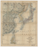
Stanford's map of eastern China, Japan and Korea : the seat of war in 1894
Contributor
Edward Stanford Ltd., author, publisher
Type
Printed
Barcode
4687820500479
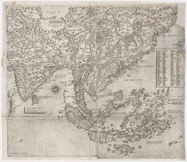
Title
The Design of the Third Part of Asia
Contributor
[Gastaldi, Giacomo, ca. 1500-ca. 1565, cartographer, Licinius, Fabius, 1521-1565, engraver, Libraria di San Marco (Venice), bookseller, Fugger, Marcus, 1529-1597, dedicatee, Hauslab, Franz, Ritter von, 1798-1883, former owner, Liechtenstein, House of, former owner]
Type
Printed
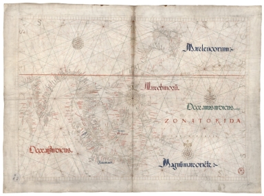
Barcode
3687800354466H
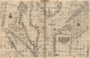
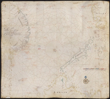
Title
Particular map of Malacca with the coast from Pegu, Cambodia with the Islands of Sumatra and northern part of Borneo many other surrounding islands and islets
Contributor
[Dudley, Robert, Sir, 1574-1649, cartographer, Lucini, Antonio Francesco, 1605-1640, engraver, Onofri, Francesco, fl. 1631-1679, printer]
Type
Printed
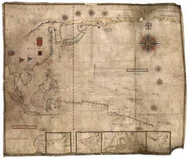
Barcode
3687800354465G
Title
Particular map of the Sea and coast of Manila
Contributor
[Dudley, Robert, Sir, 1574-1649, cartographer, Lucini, Antonio Francesco, 1605-1640, engraver, Onofri, Francesco, fl. 1631-1679, printer]
Type
Printed
Barcode
3687800354463E
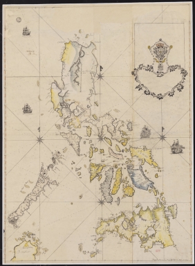
Title
Particular map of Philippine Islands and of Luzon
Contributor
[Dudley, Robert, Sir, 1574-1649, cartographer, Lucini, Antonio Francesco, 1605-1640, engraver, Onofri, Francesco, fl. 1631-1679, printer]
Type
Printed
Barcode
3687800354462D
Title
Particular map of the Strait of Manila in the Philippine Islands
Contributor
[Dudley, Robert, Sir, 1574-1649, cartographer, Lucini, Antonio Francesco, 1605-1640, engraver, Onofri, Francesco, fl. 1631-1679, printer]
Type
Printed
Barcode
3687800354461C
Title
Particular map of the Ladrões Islands with the Island of Gilolo and de Maluku Islands
Contributor
[Dudley, Robert, Sir, 1574-1649, cartographer, Lucini, Antonio Francesco, 1605-1640, engraver, Onofri, Francesco, fl. 1631-1679, printer]
Type
Printed
Barcode
3687800354460B
Title
Particular map of the southern part of Mindanao and northern part of Celebes and Gilolo and with the Maluku Islands and other surrounding islets
Contributor
[Dudley, Robert, Sir, 1574-1649, cartographer, Lucini, Antonio Francesco, 1605-1640, engraver, Onofri, Francesco, fl. 1631-1679, printer]
Type
Printed
Barcode
3687800354457H
Title
A Map of the 15 Provinces and 155 Capital Cities of the Chinese Empire
Contributor
[Couplet, Philippe, 1623-1692, cartographer, Louvemont, François de, 1648-ca. 1690, engraver, Nolin, Jean-Baptiste, 1648-1708, printer]
Type
Printed
Barcode
3687800354455F
Title
Cambodia, Siam, Borneo, Papua New Guinea
Contributor
[Dourado, Fernão Vaz, 1520-1580, cartographer, Ferron, cavalheiro, former owner, Carlos I, King of Portugal, 1863-1908, former owner, Castelo Branco, João Martens Ferrão de, fl. 1847-1891, former owner]
Type
Manuscript
Barcode
3687800354454E
Title
Carte des Isles Philippines : dressée sur la carte espagnole du R.P. Murillo de Velarde I.re feville
Contributor
[Bellin, Jacques-Nicolas, 1703-1772, cartographer, Murillo Velarde, Pedro, 1696-1753, bibliographic antecedent]
Type
Printed
Barcode
3687800354452C
Title
Far East and Insulindia
Contributor
[Dourado, Fernão Vaz, 1520-1580, cartographer, Ferron, cavalheiro, former owner, Carlos I, King of Portugal, 1863-1908, former owner, Castelo Branco, João Martens Ferrão de, fl. 1847-1891, former owner]
Type
Printed
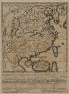
Barcode
36878003545017
Title
[Carte française de la Mer de Chine et du Golfe de Siam]
Type
Manuscripts
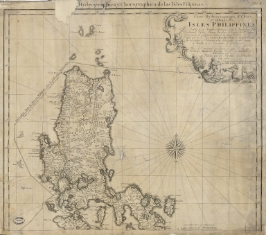
Barcode
3687800354492G
Title
Carte hydrographique & chorographique des isles Philippines : dediée à Sa Majesté Catholique, par le Brigadier Don Ferdinand Valdes Tamon, Chevalier de l'ordre de S.t Jaques, Gouverneur & Capitaine Général des dites Isles, dressée par le R. Pere Pierre Murillo Velarde, de la C. de Gieusu sur les Cartes, les Rélations et les Navigations les plus exactes à Manille 1734 par ordre de Sa Majesté
Contributor
[Lowitz, Georg Moriz, 1722-1774, cartographer, Murillo Velarde, Pedro, 1696-1753, bibliografic antecedent, Bagay, Nicolás de la Cruz, 1701-1771, engraver, Valdés y Tamón, Fernando de, 1681-ca. 1741, dedicator, Charles III, King of Spain, 1716-1788, dedicatee, Homann Erben (Firm), publisher]
Type
Printed
Barcode
36878003545028
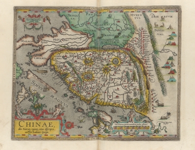
Title
Abbregé de la carte de la Chine du R.P. Michel Ruggiery Jesuiste
Contributor
[Sanson, Guillaume, 1633-1703, cartographer, Ruggieri, Michele, 1543-1607, bibliographic antecedent, Mariette, Pierre, 1634-1716, printer]
Type
Printed
Barcode
36878003545039
Title
Abbregé de la carte de la Chine du R.P. Bouyn, Jesuiste
Contributor
[Sanson, Guillaume, 1633-1703, cartographer, Boym, Michal, 1612-1659, bibliographic antecedent, Mariette, Pierre, 1634-1716, printer]
Type
Printed
Barcode
3687800354506C
Title
Map of the China Sea
Contributor
Blaeu, Joan, 1596-1673, cartographer
Type
Manuscripts
Barcode
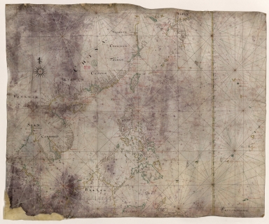
3687800354088H
Title
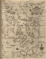
[Southeast China, Japan, East Indies (northern part)]
Contributor
[Dourado, Fernão Vaz, 1520-1580, cartographer, Huth, Henry, 1815–1878, former owner]
Type
Manuscripts
Barcode
3687800239546I
Title
Nova tabula India Orientalis
Contributor
Allard, Carel, 1648-ca. 1709, cartographer
Type
Printed
Barcode
3687800301587D
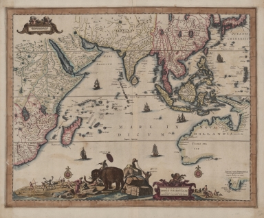
Title
A map of the East Indies and surrounding islands
Contributor
[Ortelius, Abraham, 1527-1598, author, Norton, John, 15---1612, printer]
Type
Printed
Barcode
3687800285782L
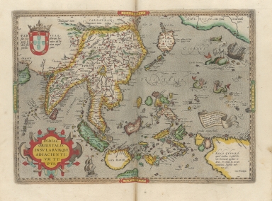
Title
A new representation of China, once called the region of the Chinese, by Ludovicus Georgius
Contributor
[Barbuda, Luís Jorge de, fl. 1575-1584, cartographer, Plantin, Christophe, ca.1520-1589, printer, Norton, John, 15---1612, printer]
Type
Printed
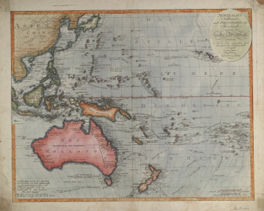
Barcode
36878003222402
Title
Australien (Südland) auch Polynesien oder Inselwelt, insgemein der fünfte Welttheil genannt : nach den neuesten und bewährtesten Hülfsmitteln entworfen
Contributor
Walch, Johannes, 1757-1816, cartographer
Type
Printed
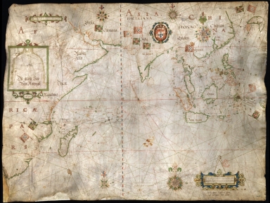
Barcode
3687800239892M
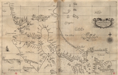
Title
[Asia]
Contributor
Albernaz, João Teixeira, fl. 1602-1649, cartographer
Type
Manuscripts
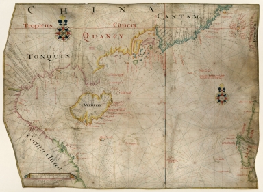
Barcode
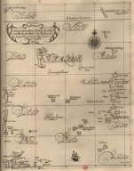
3687800354567J
Title
[Chart of the Sea of Canton to Cambodia and the Philippines]
Type
Manuscripts
Barcode
3687800354509F
Title
Map of the coasts of China and neighboring islands with some additions
Contributor
Anville, Jean Baptiste Bourguignon d', 1697-1782, cartographer
Type
Printed
Barcode
3687800317478J
Title
Dutch nautical chart of the 18th century, including the coasts of Annam, Tonkin, China, Hainan Island and part of Luzon
Contributor
Saffroy, Amand, 1844-1905, former owner
Type
Manuscripts
Barcode
3687800354255D
Title
Map of the South China Sea
Contributor
Blaeu, Joan, 1596-1673, cartographer
Type
Manuscripts
Barcode
3687800354308C
Title
Gulf of Tonkin to Luzon and Formosa
Contributor
Thornton, John, 1641-1708, hydrographer
Type
Manuscripts
Barcode
3687800317483F
Title
Dutch Chart of the China Sea
Type
Manuscripts
Barcode
3687800354561D
Title
Map of the Chinese Sea and Coast, from Drioens Strait to Nanquin, and the Islands from Borneo to Japan and Ladrones
Contributor
Blaeu, Joan, 1650-1712, cartographer
Type
Manuscripts
Barcode
3687800354228D
Title
Gulf of Tonkin
Contributor
Blaeu, Joan, 1596-1673, cartographer
Type
Manuscripts
Barcode
3687800354566I
Title
Gulf of Tonkin
Contributor
Blaeu, Joan, 1650-1712, cartographer
Type
Manuscripts
Barcode
4687820501106
Title
Filipinas
Contributor
Bagay, Nicolás de la Cruz, 1701-1771, cartographer
Type
Manuscripts
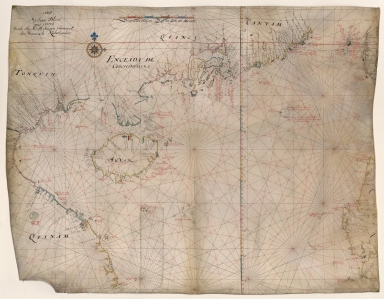
Barcode
3687800354262B
Title
Southern part of the China Se
Type
Manuscripts
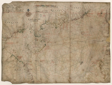
Barcode
3687800354259H
Title
Chart of the seas of Canton to Cambodia and the Philippines
Type
Manuscripts
Barcode
4687820501175
Title
A chart of the China Sea : inscribed to Mons.r d'Aprés de Mannevillette the ingenious author of the Neptune Oriental, as a tribute due to his labours for the benefit of navigation, and in acknowledgment of his many signal favours to A. Dalrymple.
Contributor
[Dalrymple, Alexander, 1737-1808, hydrographer, Henry, B., fl. 1770-1775, engraver, Whitchurch, William, fl. 18th century, engraver, Lane, Bartholomew, fl. 19th century, engraver, Après de Mannevillette, Jean-Baptiste-Nicolas-Denis d', 1707-1780, dedicatee]
Type
Printed
Barcode
36878003222312
Title
To the Society of Managing Owners of the Ships in the English East India Company's Service, This Chart of the China Sea, Including the Philippina Molluca and Banda Islands, Shewing al the same time all the Tracks into the Pacific Ocean, commonly known by the name of the Eastern Passage to China
Contributor
[Robertson, George, 1748-1788, cartographer, Harmer, Thomas, fl. 1784-1814, engraver]
Type
Printed
Barcode
3687800301756B
Title
A new chart of the oriental seas and islands with the coasts of the continent from the Isle of Ceylon to Amoye in China
Contributor
[Après de Mannevillette, Jean-Baptiste-Nicolas-Denis d', 1707-1780, cartographer, Laurie & Whittle, publisher]
Type
Printed
Barcode
687800354612A
Title
North Indian Ocean, China Sea and part of the Pacific Ocean
Contributor
Homem, Diogo, ca. 1520-1576, cartographer
Type
Manuscripts
Barcode
3687800354648J
Title
Chart of the Pacific Ocean
Contributor
Albernaz, João Teixeira, I, fl. 1602-1649, cartographer
Type
Manuscripts
Barcode
3687800354650C
Title
Nautical chart of the Indian Ocean and the Chinese seas
Contributor
Gijsbertsz, Evert, d. 1625, cartographer
Type
Manuscripts
Barcode
3687800317476H
Title
Gulf of Tonkin to Luzon and Formosa
Contributor
Thornton, John, 1641-1708, cartographer
Type
Manuscripts
Barcode
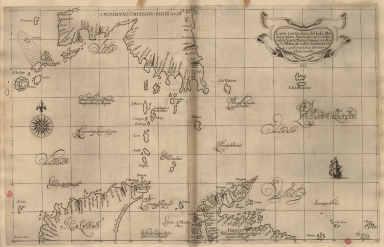
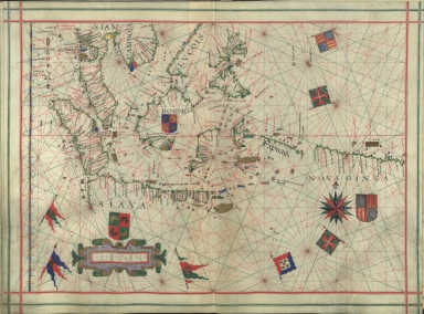
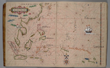
36878003541013
Title
Exacta & accurata delineatio cùm orarum maritimarum tùm etiam locorum terrestrium quae in regionibus China, Cauchinchina, Camboja sive Champa, Syao, Malacca, Arracan & Pegu, unà cum omnium vicinarum insularum descriptione ut sunt Samatra, Java utraq[ue], Timora, Molucca, Philippina, Luconia & de Lequeos dictae, nec non insulae Japan & Corea, reliquaeq[ue] omnes adjacentes, ubi etiam adnotavimus scopulos, brevia, omniaq[ue] vadosa loca, & siqua alia à quibus periculum navigantibus. Que madmodum singula hoc aevo à Lusitanis navium gubernatoribus comperta, indigetata, & in tabulas relata fuere. E quorum recentibus ac emendatis tabulis perquàm studiosè haec describi exprimiq[ue] curavimus, in eorum hominum co[m]modum quibus ista usui volupatiq[ue] esse consueueru[n]t = Waarachtige wtworpinghe oste afbeeldinge van alle die custen ende landen van China, Cauchinchina, Camboja, Sÿao, Malacca, Arracan ende Pegu, mitsgaders alle die biileggende eÿlanden groote ende cleinen, mit noch die clippen, riffen, sanden, droochten ende ondiepten, alles wt de alder correckste pas ende Lees-caarten getrocken die de Portugaloissche Stvÿrlviiden huiidendaechs gebruiicken.
Exacta & accurata delineatio cùm orarum maritimarum tùm etiam locorum terrestrium quae in regionibus China, Cauchinchina, Camboja sive Champa, Syao, Malacca, Arracan & Pegu, unà cum omnium vicinarum insularum descriptione ut sunt Samatra, Java utraq[ue], Timora, Molucca, Philippina, Luconia & de Lequeos dictae, nec non insulae Japan & Corea, reliquaeq[ue] omnes adjacentes, ubi etiam adnotavimus scopulos, brevia, omniaq[ue] vadosa loca, & siqua alia à quibus periculum navigantibus. Que madmodum singula hoc aevo à Lusitanis navium gubernatoribus comperta, indigetata, & in tabulas relata fuere. E quorum recentibus ac emendatis tabulis perquàm studiosè haec describi exprimiq[ue] curavimus, in eorum hominum co[m]modum quibus ista usui volupatiq[ue] esse consueueru[n]t = Waarachtige wtworpinghe oste afbeeldinge van alle die custen ende landen van China, Cauchinchina, Camboja, Sÿao, Malacca, Arracan ende Pegu, mitsgaders alle die biileggende eÿlanden groote ende cleinen, mit noch die clippen, riffen, sanden, droochten ende ondiepten, alles wt de alder correckste pas ende Lees-caarten getrocken die de Portugaloissche Stvÿrlviiden huiidendaechs gebruiicken.
Contributor
Linschoten, Jan Huygen van, 1563-1611, cartographer
Type
Printed
|
![[Carte française de la Mer de Chine et du Golfe de Siam]](http://lunamap.must.edu.mo:80/MediaManager/srvr?mediafile=/Size1/MUST~2~2/63/GE+SH+18+PF+181+P+9+RES+-+Carte+fran%C3%83%C2%A7aise+de+la+Mer+de+Chine+et+du+Golfe+de+Siam.jpg)
![[Southeast China, Japan, East Indies (northern part)]](http://lunamap.must.edu.mo:80/MediaManager/srvr?mediafile=/Size2/MUST~2~2/45/000434.jpg)
![[Asia]](http://lunamap.must.edu.mo:80/MediaManager/srvr?mediafile=/Size2/MUST~2~2/41/G1015+.T4+1630-12.jpg)
![[Chart of the Sea of Canton to Cambodia and the Philippines]](http://lunamap.must.edu.mo:80/MediaManager/srvr?mediafile=/Size2/MUST~2~2/54/GE+SH+18+PF+181+P+21+RES+Carte+des+mers+de+Canton.jpg)


![Exacta & accurata delineatio cùm orarum maritimarum tùm etiam locorum terrestrium quae in regionibus China, Cauchinchina, Camboja sive Champa, Syao, Malacca, Arracan & Pegu, unà cum omnium vicinarum insularum descriptione ut sunt Samatra, Java utraq[ue], Timora, Molucca, Philippina, Luconia & de Lequeos dictae, nec non insulae Japan & Corea, reliquaeq[ue] omnes adjacentes, ubi etiam adnotavimus scopulos, brevia, omniaq[ue] vadosa loca, & siqua alia à quibus periculum navigantibus. Que madmodum singula hoc aevo à Lusitanis navium gubernatoribus comperta, indigetata, & in tabulas relata fuere. E quorum recentibus ac emendatis tabulis perquàm studiosè haec describi exprimiq[ue] curavimus, in eorum hominum co[m]modum quibus ista usui volupatiq[ue] esse consueueru[n]t = Waarachtige wtworpinghe oste afbeeldinge van alle die custen ende landen van China, Cauchinchina, Camboja, Sÿao, Malacca, Arracan ende Pegu, mitsgaders alle die biileggende eÿlanden groote ende cleinen, mit noch die clippen, riffen, sanden, droochten ende ondiepten, alles wt de alder correckste pas ende Lees-caarten getrocken die de Portugaloissche Stvÿrlviiden huiidendaechs gebruiicken.
Exacta & accurata delineatio cùm orarum maritimarum tùm etiam locorum terrestrium quae in regionibus China, Cauchinchina, Camboja sive Champa, Syao, Malacca, Arracan & Pegu, unà cum omnium vicinarum insularum descriptione ut sunt Samatra, Java utraq[ue], Timora, Molucca, Philippina, Luconia & de Lequeos dictae, nec non insulae Japan & Corea, reliquaeq[ue] omnes adjacentes, ubi etiam adnotavimus scopulos, brevia, omniaq[ue] vadosa loca, & siqua alia à quibus periculum navigantibus. Que madmodum singula hoc aevo à Lusitanis navium gubernatoribus comperta, indigetata, & in tabulas relata fuere. E quorum recentibus ac emendatis tabulis perquàm studiosè haec describi exprimiq[ue] curavimus, in eorum hominum co[m]modum quibus ista usui volupatiq[ue] esse consueueru[n]t = Waarachtige wtworpinghe oste afbeeldinge van alle die custen ende landen van China, Cauchinchina, Camboja, Sÿao, Malacca, Arracan ende Pegu, mitsgaders alle die biileggende eÿlanden groote ende cleinen, mit noch die clippen, riffen, sanden, droochten ende ondiepten, alles wt de alder correckste pas ende Lees-caarten getrocken die de Portugaloissche Stvÿrlviiden huiidendaechs gebruiicken.](http://lunamap.must.edu.mo:80/MediaManager/srvr?mediafile=/Size2/MUST~2~2/354/36878003541013%28MAP+RM+4945%29.jpg)