|
REFINE
Browse All : Sea Charts of Taiwan and Vietnam
1-25 of 25
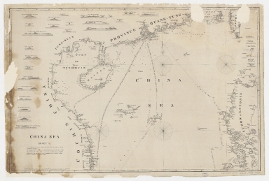
Barcode
4687820500105
Title
China Sea. Sheet II
Contributor
Horsburgh, James, 1762-1836, cartographer, publisher
Type
Printed
Barcode
4687820500218
Title
A chart of the China Sea : inscribed to Mons.r D'Aprés de Mannevillette the ingenious author of the Neptune Oriental, as a tribute due to his labours for the benefit of Navigation, and in acknowledgement of his many signal favours to Dalrymple.
Contributor
[Dalrymple, Alexander, 1737-1808, hydrographer, Demonville, Antoine Guénard, ca. 1733-1797, printer, Malassis, Romain-Nicolas, 1737-1813, printer, Après de Mannevillette, Jean-Baptiste-Nicolas-Denis d', 1707-1780, dedicatee]
Type
Printed
Barcode
4687820500336
Title
A new chart of the China Sea, with its several entrances : drawn from a great number of draughts, journals, and other National documents, regulated by astronomical observations
Contributor
[Laurie & Whittle, author, publisher, Larkins, John Pascal, 17---1794, cartographer, Rees, Captain, cartographer]
Type
Printed
Barcode
3687800354267G
Title
A new chart of the China Sea, with its several entrances : drawn from a great number of draughts, journals, and other National documents, regulated by astronomical observation
Contributor
[Laurie & Whittle, author, publisher, Larkins, John Pascal, 17---1794, cartographer, Rees, Captain, cartographer]
Type
Printed
Barcode
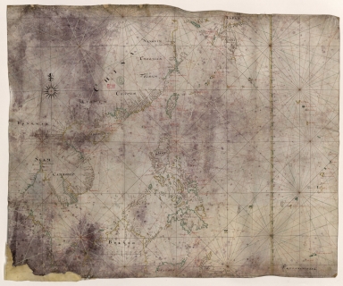
4687820501172
Title
[Route de M. de Richery en 1787 de Pondichery a Canton]
Type
Manuscripts
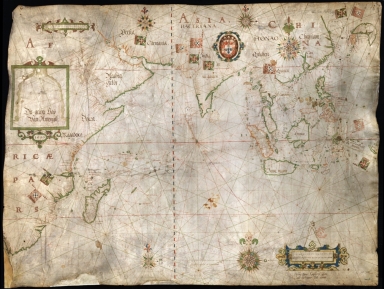
Barcode
4687820501071
Title
Seconde partie de la carte d'Asie : contenant la Chine, et partie de la Tartarie, l'Inde au delà du Gange, les Isles Sumatra, Java, Borneo, Moluques, Philippines et du Japon. Publiée sous les auspices de Monseigneur Louis-Philippe D'Orléans, Duc D'Orléans, prémier Prince du Sang
Contributor
Anville, Jean Baptiste Bourguignon d', 1697-1782, cartographer
Type
Manuscripts
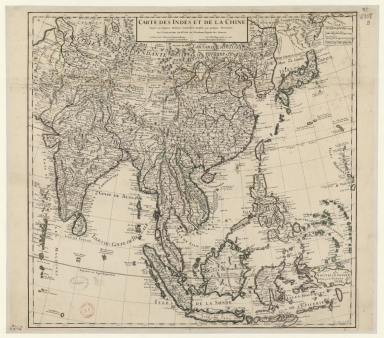
Barcode
4687820501075
Title
Carte des Indes et de la Chine : dressée sur plusieurs relations particulières rectifiées par quelques observations
Contributor
[Delisle, Guillaume, 1675-1726, cartographer, publisher, Renard, Louis, ca. 1678-1746, publisher]
Type
Manuscripts
Barcode
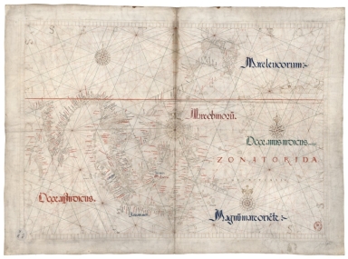
4687820500981
Title
East Indian Ocean and China Sea
Contributor
Albernaz, João Teixeira, fl. 1602-1649, cartographer
Type
Manuscripts
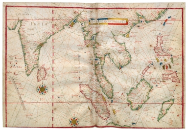
Barcode
3687800354506C
Title
Map of the China Sea
Contributor
Blaeu, Joan, 1596-1673, cartographer
Type
Manuscripts
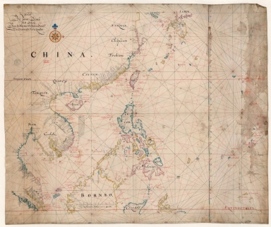
Barcode
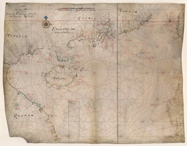
3687800354567J
Title
[Chart of the Sea of Canton to Cambodia and the Philippines]
Type
Manuscripts
Barcode
3687800354509F
Title
Map of the coasts of China and neighboring islands with some additions
Contributor
Anville, Jean Baptiste Bourguignon d', 1697-1782, cartographer
Type
Printed
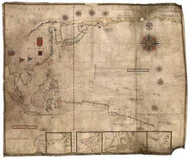
Barcode
3687800317478J
Title
Dutch nautical chart of the 18th century, including the coasts of Annam, Tonkin, China, Hainan Island and part of Luzon
Contributor
Saffroy, Amand, 1844-1905, former owner
Type
Manuscripts
Barcode
3687800354308C
Title
Gulf of Tonkin to Luzon and Formosa
Contributor
Thornton, John, 1641-1708, hydrographer
Type
Manuscripts
Barcode
3687800317483F
Title
Dutch Chart of the China Sea
Type
Manuscripts
Barcode
3687800354561D
Title
Map of the Chinese Sea and Coast, from Drioens Strait to Nanquin, and the Islands from Borneo to Japan and Ladrones
Contributor
Blaeu, Joan, 1650-1712, cartographer
Type
Manuscripts
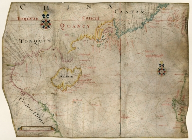
Barcode
3687800354228D
Title
Gulf of Tonkin
Contributor
Blaeu, Joan, 1596-1673, cartographer
Type
Manuscripts
Barcode
3687800354566I
Title
Gulf of Tonkin
Contributor
Blaeu, Joan, 1650-1712, cartographer
Type
Manuscripts
Barcode
4687820501175
Title
A chart of the China Sea : inscribed to Mons.r d'Aprés de Mannevillette the ingenious author of the Neptune Oriental, as a tribute due to his labours for the benefit of navigation, and in acknowledgment of his many signal favours to A. Dalrymple.
Contributor
[Dalrymple, Alexander, 1737-1808, hydrographer, Henry, B., fl. 1770-1775, engraver, Whitchurch, William, fl. 18th century, engraver, Lane, Bartholomew, fl. 19th century, engraver, Après de Mannevillette, Jean-Baptiste-Nicolas-Denis d', 1707-1780, dedicatee]
Type
Printed
Barcode
3687800317471C
Title
A new and correct chart of the coast of China : from latitude 12° north to 26° including Formosa, Hayman and the Philippine Islands.
Contributor
W. and J. Mount, T. and T. Page, 1747-1763, publisher, bookseller
Type
Printed
Barcode
3687800301756B
Title
A new chart of the oriental seas and islands with the coasts of the continent from the Isle of Ceylon to Amoye in China
Contributor
[Après de Mannevillette, Jean-Baptiste-Nicolas-Denis d', 1707-1780, cartographer, Laurie & Whittle, publisher]
Type
Printed
Barcode
687800354612A
Title
North Indian Ocean, China Sea and part of the Pacific Ocean
Contributor
Homem, Diogo, ca. 1520-1576, cartographer
Type
Manuscripts
Barcode
3687800354648J
Title
Chart of the Pacific Ocean
Contributor
Albernaz, João Teixeira, I, fl. 1602-1649, cartographer
Type
Manuscripts
Barcode
3687800354650C
Title
Nautical chart of the Indian Ocean and the Chinese seas
Contributor
Gijsbertsz, Evert, d. 1625, cartographer
Type
Manuscripts
1-25 of 25
|


![[Route de M. de Richery en 1787 de Pondichery a Canton]](http://lunamap.must.edu.mo:80/MediaManager/srvr?mediafile=/Size2/MUST~2~2/54/GE+SH+18+PF+182+P+6+D_Routes+de+M+de+Richery+en+1787.jpg)

![[Chart of the Sea of Canton to Cambodia and the Philippines]](http://lunamap.must.edu.mo:80/MediaManager/srvr?mediafile=/Size2/MUST~2~2/54/GE+SH+18+PF+181+P+21+RES+Carte+des+mers+de+Canton.jpg)