REMOVEWHO
WHEN
|
Barcode
4687820500011
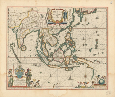
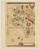
Title
Blaeu map of Southeast Asia and the surrounding areas
Contributor
Blaeu, Willem Janszoon, 1571-1638
Type
Printed
Barcode
4687820500534
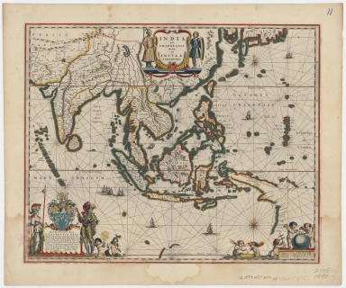
Title
Blaeu map of Southeast Asia and the surrounding areas
Contributor
Blaeu, Willem Janszoon, 1571-1638
Type
Printed
Barcode
4687820500604
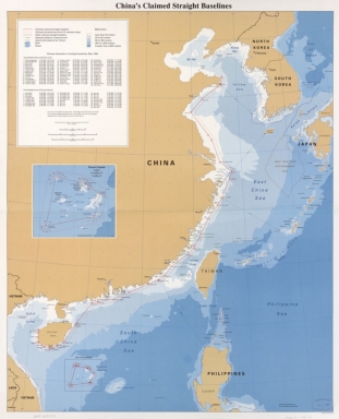
Title
China's claimed straight baselines
Contributor
United States. Central Intelligence Agency
Type
Printed
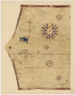
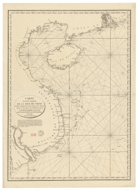
Barcode
4687820500041
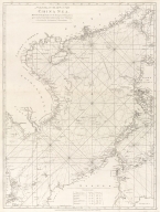
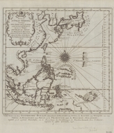
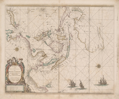
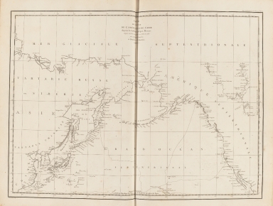
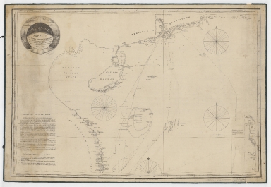
Title
[Chart of the China Sea]
Contributor
Norie, J. W. (John William), 1772-1843
Type
Printed
Barcode
4687820500016
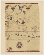
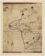
Title
Map of the World by Viconte di Maiollo, 1527.Part 1
Contributor
[Maggiolo, Vesconte, active 1504-1549, Weisl, Arthur James, 1838-1910 or 1911]
Type
Printed
Barcode
4687820500017
Title
Map of the World by Viconte di Maiollo, 1527.Part 2
Contributor
[Maggiolo, Vesconte, active 1504-1549, Weisl, Arthur James, 1838-1910 or 1911]
Type
Printed
Barcode
4687820500782
Title
A chart of the East India Islands with the coasts of the continent from Caliminera Point to Amoye in China
Contributor
Anonymous
Type
Printed
Barcode
4687820500018
Title
Map of the World by Viconte di Maiollo, 1527.Part 3
Contributor
[Maggiolo, Vesconte, active 1504-1549, Weisl, Arthur James, 1838-1910 or 1911]
Type
Printed
Barcode
4687820500783
Title
A general chart of the China Sea : drawn from the journals of the European navigators, particularly from those collected by Capt. Hayter
Contributor
Anonymous
Type
Printed
Barcode
4687820500785
Title
A chart of the eastermost part of the East Indies from the island Zeloan to Amoy in China : with the adjacent islands adjusted according to the most accurate astronomical observations
Contributor
Seller, John, active 1658-1698
Type
Printed
Barcode
4687820500788
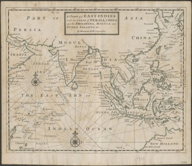
Title
A chart of ye East-Indies with the coast of Persia, China also the Philipina, Moluca and Sunda Islands, &c.
Contributor
Moll, Herman, -1732
Type
Printed
Barcode
4687820500789
Title
Suite de L'Ocean Oriental : contenant les Isles de la Sonde les Costes de Tunquin et de la Chine, les Isles du Japon, les Philippines Moluques
Contributor
[Bellin, Jacques Nicolas, 1703-1772, Hondt, Pieter de, Schley, Jacobus van der, 1715-1779]
Type
Printed
Barcode
4687820500019
Title
Map of the World by Viconte di Maiollo, 1527.Part 4
Contributor
[Maggiolo, Vesconte, active 1504-1549, Weisl, Arthur James, 1838-1910 or 1911]
Type
Printed
Barcode
4687820500795
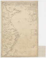
Title
Pacific Ocean : Chusan Islands to Shark Bay, Western Australia
Contributor
[Great Britain. Hydrographic Department, J. & C. Walker (Firm)]
Type
Printed
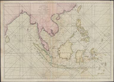
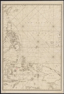
Barcode
4687820500800
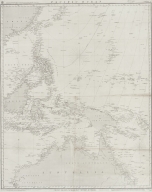
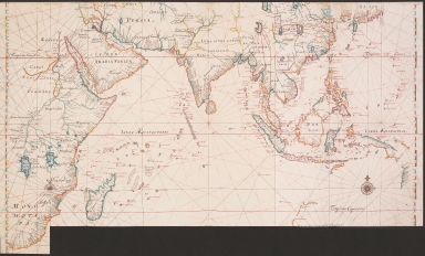
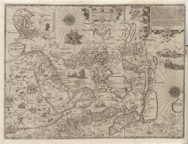
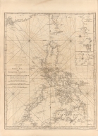
Title
[Map of the East Indies]
Contributor
Anonymous
Type
Printed
Barcode
4687820500802
Title
Paskaerte Zynde t'Oosterdeel Van Oost Indien : met alle de Eylanden deer ontrendt geleegen van C. Comorin tot aen Japan
Contributor
Goos, Pieter, approximately 1616-1675
Type
Printed
Barcode
4687820500094
Title
Map of the Indian Ocean
Contributor
Vinckeboons, Joan
Type
Printed
Barcode
4687820500855
Title
Map of the western Pacific ocean and the Asiatic coast
Contributor
Anonymous
Type
Printed
Barcode
4687820500120
Title
Plan of the entrance of Aimoey Harbour of Chinchew River &c.
Contributor
Keulen, Johannes van, 1654-1715
Type
Printed
Barcode
4687820500131
Title
Carte des côtes de l'Amérique et de l'Asie : depuis la Californie jusqu'à Macao
Contributor
La Pérouse, Jean-François de Galaup, comte de, 1741-1788
Type
Printed
Barcode
4687820500108
Title
The Nauigation of the Portingales into the East Indies, containing their trauels by Sea, into East India, and from the East Indies into Portingall, also from the Portingall Indies to Malacca, China, Iapon, the Islands of Iaua and Sunda ...
Contributor
[Wolfe, John, Phillip, William, Linschoten, Jan Huygen van, 1563-1611]
Type
Printed
Barcode
4687820500450
Title
To John Reeves Esq.re F.R.S. for the liberal aid of his Chinese m.s.s. and the benefit derived from his excellent map of that Empire presented by him to the Hon.ble East India Company this Chart of the East Coast of China
Contributor
[Horsburgh, James, 1762-1836, author, publisher, J. & C. Walker (Firm), engraver, Ross, Daniel, 1780-1849, cartographer, Hall, Basil, 1788-1844, cartographer, Crawford, James H., fl. 18--, cartographer, Rancliffe, George Augustus Henry Anne Parkyns, Baron, 1785-1850, cartographer, Rees, Thomas, 1790-1870, cartographer, Dayot, Félix, 1772-1821, cartographer, Sturgis, Josiah, 1773-1850, cartographer, Rees, John, 1752-18--, cartographer, Hoskiaer, Jacob, 1808-1836, cartographer, Dalrymple, Alexander, 1737-1808, bibliographic antecedent, Reeves, John, 1774-1856, dedicatee]
Type
Printed
Barcode
4687820500574
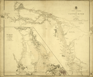
Title
Chu-Kiang or Canton River from Boca Tigris to Canton
Type
Printed
Barcode
4687820500570
Title
China. Sheet 1. Eastern Coast. From Hui Ling San Harbour to Hong Kong
Contributor
Great Britain. Admiralty, Hydrographic Office
Type
Printed
Barcode
4687820500572
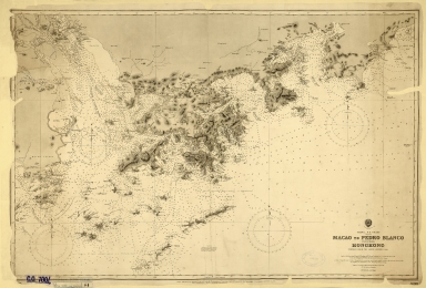
Title
China. S.E. Coast. Macao to Pedro Blanco, including Hongkong
Contributor
Davies & Company
Type
Printed
Barcode
4687820500571
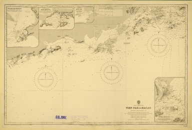
Title
China-South Coast : Tien Pak to Macao : from various sketch surveys 1807-1882
Contributor
Davies & Company
Type
Printed
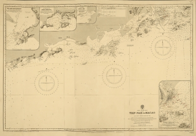
Barcode
4687820500573
Title
China-South Coast : Tien Pak to Macao : from various sketch surveys 1807-1882
Contributor
Davies & Company
Type
Printed
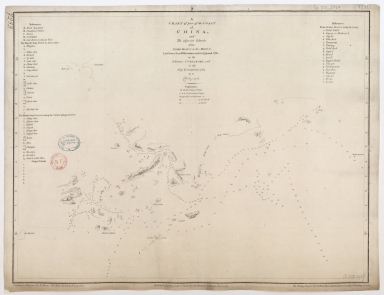
Barcode
4687820500622
Title
Carta Universal en que se contiene todo lo que del mundo se ha descubierto fasta agora / hizola Diego Ribero cosmographo de Su magestad, Anõ de 1529. e[n] Sevilla. La qual se devide en dos partes conforme ala capitulaçion que hizieron los catholicos Reyes de españa [y] el Rey don Juan de portogual en Tordesillas, Anõ de 1494.
Contributor
[Ribeiro, Diogo, fl. 1519-1533, cartographer, Griggs, William, 1832-1911]
Type
Printed
Barcode
4687820500658
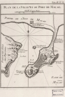
Title
Plan de la ville et du port de Macao
Contributor
Bellin, Jacques-Nicolas, 1703-1772, cartographer
Type
Printed
Barcode
4687820500498
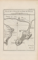
Title
Plan de la ville et du port de Macao
Contributor
Bellin, Jacques-Nicolas, 1703-1772, cartographer
Type
Printed
Barcode
4687820500710
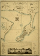
Title
A map of the city and harbour of Macao
Contributor
Bramston, William, 17---18--, author
Type
Printed
Barcode
4687820500105
Title
China Sea. Sheet II
Contributor
Horsburgh, James, 1762-1836, cartographer, publisher
Type
Printed
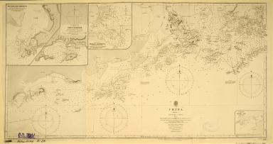
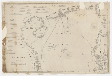
Barcode
4687820500050
Title
China Sea. Sheet 1.st to James Drummond Esquire in acknowledgement for his laudable endeavours towards perfecting the navigation of the China Sea
Contributor
[Horsburgh, James, 1762-1836, cartographer, publisher, James Drummond, 8th Viscount Strathallan, 1767-1851, dedicatee]
Type
Printed
Barcode
4687820500260
Title
A chart of the China Sea, and Philippine Islands with the Archipelagos of Felicia and Soloo : shewing the whole tract comprized, between Canton and Balambangan, with the soundings, shoals, rocks, & ca.
Contributor
Whittle & Laurie, publisher
Type
Printed
Barcode
4687820500255
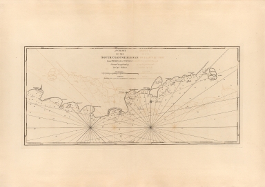
Title
A chart of the south coast of Hay-nan, from Tinhosa to Guichou
Contributor
[Haldane, John, captain, fl. 177-, cartographer, Laurie & Whittle, publisher]
Type
Printed
Barcode
4687820500370
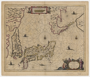
Title
Nova et accurata Japoniae, terrae Esonis ac insularum adjacentium ex novissimâ detectione descriptio.
Contributor
Jansson, Jan, 1588-1664, printer
Type
Printed
Barcode
4687820500218
Title
A chart of the China Sea : inscribed to Mons.r D'Aprés de Mannevillette the ingenious author of the Neptune Oriental, as a tribute due to his labours for the benefit of Navigation, and in acknowledgement of his many signal favours to Dalrymple.
Contributor
[Dalrymple, Alexander, 1737-1808, hydrographer, Demonville, Antoine Guénard, ca. 1733-1797, printer, Malassis, Romain-Nicolas, 1737-1813, printer, Après de Mannevillette, Jean-Baptiste-Nicolas-Denis d', 1707-1780, dedicatee]
Type
Printed
Barcode
4687820501174
Title
Carte d'une partie de la mer de Chine
Contributor
Rosili Mesros, François Etienne de, 1748-1832, bibliographic antecedent
Type
Printed
Barcode
3687800354287I
Title
To the Honorable the Court of Directors of the United Company of Merchants of England trading to the East Indies, this Chart of the China Seas
Contributor
[Heather, William, 1764-1812, hydrographer, Stephenson, John,, fl. 1791-1817, engraver, Norie, John William, 1772-1843, illustrator, Heather and Williams, publisher]
Type
Printed
Barcode
3687800354289K
Title
To the Honorable the Court of Directors of the United Company of Merchants of England trading to the East Indies, this Chart of the China Seas
Contributor
[Heather, William, 1764-1812, hydrographer, Stephenson, John,, fl. 1791-1817, engraver, Norie, John William, 1772-1843, illustrator, Heather and Williams, publisher]
Type
Printed
Barcode
4687820500336
Title
A new chart of the China Sea, with its several entrances : drawn from a great number of draughts, journals, and other National documents, regulated by astronomical observations
Contributor
[Laurie & Whittle, author, publisher, Larkins, John Pascal, 17---1794, cartographer, Rees, Captain, cartographer]
Type
Printed
Barcode
3687800354267G
Title
A new chart of the China Sea, with its several entrances : drawn from a great number of draughts, journals, and other National documents, regulated by astronomical observation
Contributor
[Laurie & Whittle, author, publisher, Larkins, John Pascal, 17---1794, cartographer, Rees, Captain, cartographer]
Type
Printed
Barcode
4687820501177
Title
A chart of part of the coast of China, and the adjacent islands from Pedro Blanco to the Mizen : laid down from observations made in 1759 and 1760, in the Schooner Cuddalore, and in the Ship London, 1764
Contributor
[Dalrymple, Alexander, 1737-1808, hydrographer, publisher, Henry, B., fl. 1770-1775, engraver, Lerpinière, Daniel, 1745-1785, engraver, Whitchurch, William, fl. 18th century, engraver, Lane, Bartholomew, fl. 19th century, engraver]
Type
Printed
Barcode
4687820501171
Title
Chart of the Strait of Solor : from a Portuguese ms used by the Portuguese of Macao in the navigation to Timor
Contributor
[Harmer, Thomas, fl. 1784-1814, engraver, Dalrymple, Alexander, 1737-1808, publisher]
Type
Printed
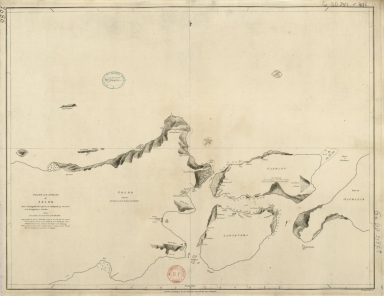
Barcode
4687820501007
Title
[[Carte portugaise de la mer des Indes entre le Cap de Bonne Espérance et le Cap Comorin] ; [Carte portugaise de la mer qui comprend le Golfe du bengale, les côtes de la Chine et les îles du Japon, Philippines, de la Sonde et Moluques], [Carte portugaise de la mer qui comprend le Golfe du bengale, les côtes de la Chine et les îles du Japon, Philippines, de la Sonde et Moluques]]
Contributor
Albernaz, João Teixeira, fl. 1602-1649, cartographer
Type
Printed
Barcode
4687820501029
Title
[[Carte portugaise de la mer des Indes entre le Cap de Bonne Espérance et le Cap Comorin] ; [Carte portugaise de la mer qui comprend le Golfe du bengale, les côtes de la Chine et les îles du Japon, Philippines, de la Sonde et Moluques], [Carte portugaise de la mer des Indes entre le Cap de Bonne Espérance et le Cap Comorin]]
Contributor
Albernaz, João Teixeira, fl. 1602-1649, cartographer
Type
Printed
Barcode
4687820501178
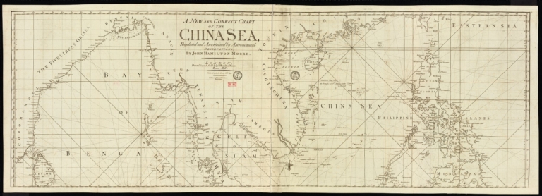
Title
A new and correct chart of the China Sea
Contributor
[Moore, John Hamilton, 1738-1807, cartographer, Blake, T. J., fl. 1785-1785, engraver]
Type
Printed
Barcode
4687820500373
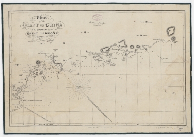
Title
Chart of the coast of China to the eastward of the great Ladrone
Contributor
[Ross, Daniel, 1780-1849, cartographer, Horsburgh, James, 1762-1836, publisher]
Type
Printed
Barcode
4687820500010
Title
Carte de l'entrée de la riviere de Canton dans la Chine
Contributor
Bellin, Jacques-Nicolas, 1703-1772, cartographer
Type
Printed
|
![[Chart of the China Sea]](http://lunamap.must.edu.mo:80/MediaManager/srvr?mediafile=/Size2/MUST~2~2/25/G7822_P4_1840_N6.jpg)

![[Map of the East Indies]](http://lunamap.must.edu.mo:80/MediaManager/srvr?mediafile=/Size2/MUST~2~2/41/RBRS+N+910.91+T418-69.jpg)
![Carta Universal en que se contiene todo lo que del mundo se ha descubierto fasta agora / hizola Diego Ribero cosmographo de Su magestad, Anõ de 1529. e[n] Sevilla. La qual se devide en dos partes conforme ala capitulaçion que hizieron los catholicos Reyes de españa [y] el Rey don Juan de portogual en Tordesillas, Anõ de 1494.](http://lunamap.must.edu.mo:80/MediaManager/srvr?mediafile=/Size3/MUST~2~2/30/G3200+1529+.R5+1887+MLC.jpg)


![[[Carte portugaise de la mer des Indes entre le Cap de Bonne Espérance et le Cap Comorin] ; [Carte portugaise de la mer qui comprend le Golfe du bengale, les côtes de la Chine et les îles du Japon, Philippines, de la Sonde et Moluques], [Carte portugaise de la mer qui comprend le Golfe du bengale, les côtes de la Chine et les îles du Japon, Philippines, de la Sonde et Moluques]]](http://lunamap.must.edu.mo:80/MediaManager/srvr?mediafile=/Size2/MUST~2~2/54/GE+DD-2987+Carte+portugaise+de+la+mer+des+Indes+-2+.jpg)
![[[Carte portugaise de la mer des Indes entre le Cap de Bonne Espérance et le Cap Comorin] ; [Carte portugaise de la mer qui comprend le Golfe du bengale, les côtes de la Chine et les îles du Japon, Philippines, de la Sonde et Moluques], [Carte portugaise de la mer des Indes entre le Cap de Bonne Espérance et le Cap Comorin]]](http://lunamap.must.edu.mo:80/MediaManager/srvr?mediafile=/Size1/MUST~2~2/54/GE+DD-2987+Carte+portugaise+de+la+mer+des+Indes+-1+.jpg)