|
REFINE
Search Results: All Fields similar to 'Macao and its Surroundings' and What equal to 'Manuscripts' and What equal to 'Sea Charts'
1-25 of 25
Barcode
4687820501072
Title
De Eӯlanden van Macaoủ, loopende van, t’Eӯlandt S.t Jủan totaande Stadt Canton
Contributor
De Graaf, Isaac, 1667-1743
Type
Manuscripts
Barcode
3687800354678M
Title
South China Coast from St. John Island to the Lamma Islands
Type
Manuscripts
Barcode
3687800354681G
Title
Carte d'une partie de la côte de la Chine et des îles adjacentes depuis la pierre blanche jusqu'à l'isle nommée l'Artimon tracée sur les observations faites en 1759 & 1760 du senau Le Goudelours du v.au Le Londres en 1764
Contributor
Dalrymple, Alexander, 1737-1808, cartographer
Type
Manuscripts
Barcode
3687800354676K
Title
Carte particuliere de l'entrée de la Riviere de Canton
Type
Manuscripts
Barcode
4687820500556
Title
海疆洋界形勢全圖.Part 4 = Coastal map of China.Part 4
Contributor
Anonymous
Type
Manuscripts
Barcode
4687820500561
Title
海疆洋界形勢圖.Part 3
Contributor
Hummel, Arthur W. (Arthur William), 1884-1975
Type
Manuscripts
Barcode
4687820501208
Title
Plan de la rivière de Canton dans la Chinne dans la partie du nord
Contributor
Anonymous
Type
Manuscripts
Barcode
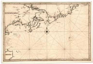
4687820501199
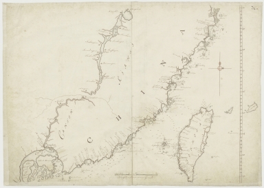
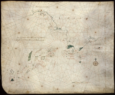
Title
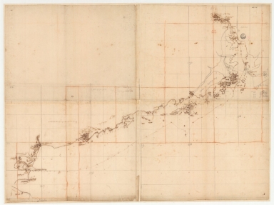
Carte de la rivière de Canton et de ses environs du costé du sud est [corrigé :] ouest
Type
Manuscripts
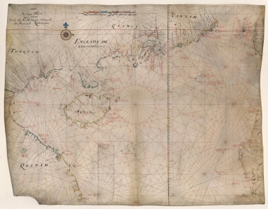
Barcode
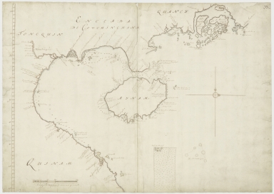
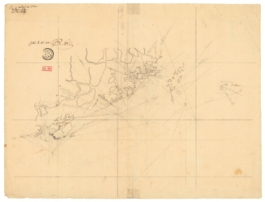
4687820500849
Title
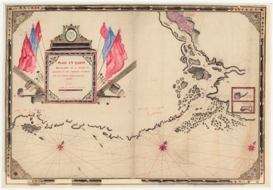
[Carta náutica de Macau e das ilhas de Cantão]
Contributor
Anonymous
Type
Manuscripts
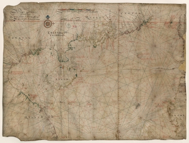
Barcode
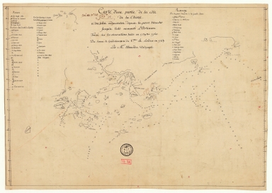
4687820501101
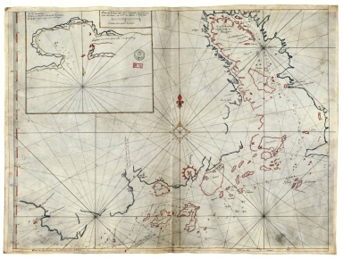
Title
Carte plate d'une partie de la coste de Chine, depuis les isles Pulo-Taya au nord est de l'isle de Haynam, et toutes les isles tant de la la partie de l'ouest que celles de l'e[st] servant de reconnoissance pour l'entrée de la rivière de Canton
Contributor
Dauge, Philippe
Type
Manuscripts
Barcode
4687820501205
Title
Carte de l'entrée de Canton où sont marquez exactement tous les mouillages, que nous fismes depuis l'isle de Sanciam, les bancs, les roches et autres dangers que j'ay pu reconnoître
Contributor
Anonymous
Type
Manuscripts
Barcode
3687800354661E
Title
Chart of the coasts of China from Hainan Island to Guangzhou
Type
Manuscripts
Barcode
36878003541204
Title
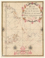
Plan et carte particuliere de la riviere de Cantong et ses environs et depuis l'isle de Sancien jusque a celle de Makao
Contributor
La Grange-Chancel, Louis de, 1678-1747, cartographer
Type
Manuscripts
Barcode
36878003541248
Title
Plan de la riviere de Canton, Macao, et autres isles circonvoisines
Contributor
Liébaut, 16---17--, catographer
Type
Manuscripts
Barcode
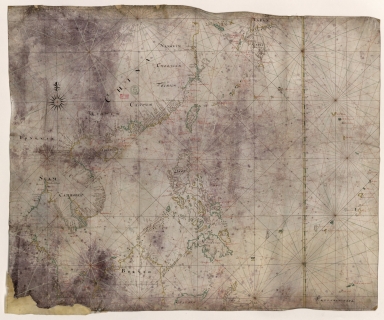
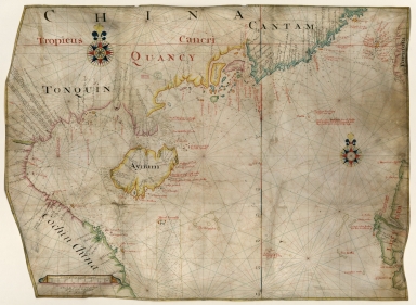
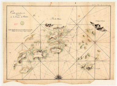
4687820500576
Title
[Tonquin, Quancy, Aynam]
Contributor
[Hacke, William, fl. 16--, cartographer, Sharpe, Bartholomew, fl. 1679-1682, author]
Type
Manuscripts
Barcode
3687800317483F
Title
Dutch Chart of the China Sea
Type
Manuscripts
Barcode
3687800317484G
Title
Handwritten map of the coasts of the province of Canton
Contributor
Jaillot, Alexis Hubert, ca. 1632-1712, cartographer
Type
Manuscripts
Barcode
3687800317478J
Title
Dutch nautical chart of the 18th century, including the coasts of Annam, Tonkin, China, Hainan Island and part of Luzon
Contributor
Saffroy, Amand, 1844-1905, former owner
Type
Manuscripts
Barcode
3687800354308C
Title
Gulf of Tonkin to Luzon and Formosa
Contributor
Thornton, John, 1641-1708, hydrographer
Type
Manuscripts
Barcode
3687800354228D
Title
Gulf of Tonkin
Contributor
Blaeu, Joan, 1596-1673, cartographer
Type
Manuscripts
Barcode
3687800354566I
Title
Gulf of Tonkin
Contributor
Blaeu, Joan, 1650-1712, cartographer
Type
Manuscripts
Barcode
4687820500578
Title
Kaart van een gedeelte der Chineese Zee en Kust, van Punta Lampa cao tot de Overveens Eilanden, het Eiland Formosa enz. Hierop komt mede voor de rivier van Canton, van den mond tot Fangsucis
Contributor
Anonymous
Type
Manuscripts
Barcode
4687820500579
Title
Kaart van de Kust van Quinam, Tonquin en Cochin-China, van R. Cantaon tot aan Punta Lamtaon, benevens het Eyland Aynam en Isla de Pracel
Contributor
Anonymous
Type
Manuscripts
Barcode
36878003541237
Title
Plan de la Riviere de Canton en Chine
Type
Manuscripts
1-25 of 25
|
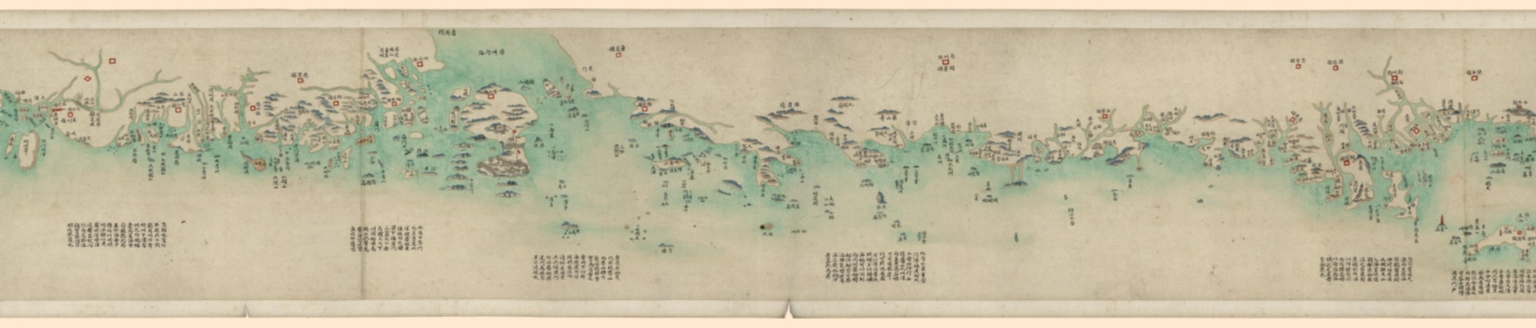
![Carte de la rivière de Canton et de ses environs du costé du sud est [corrigé :] ouest](http://lunamap.must.edu.mo:80/MediaManager/srvr?mediafile=/Size2/MUST~2~2/63/GE+SH+18+PF+179+DIV+9+P+131+D+-+Carte+de+la+rivi%C3%83%C2%A8re+de+Canton+-+sud+est.jpg)
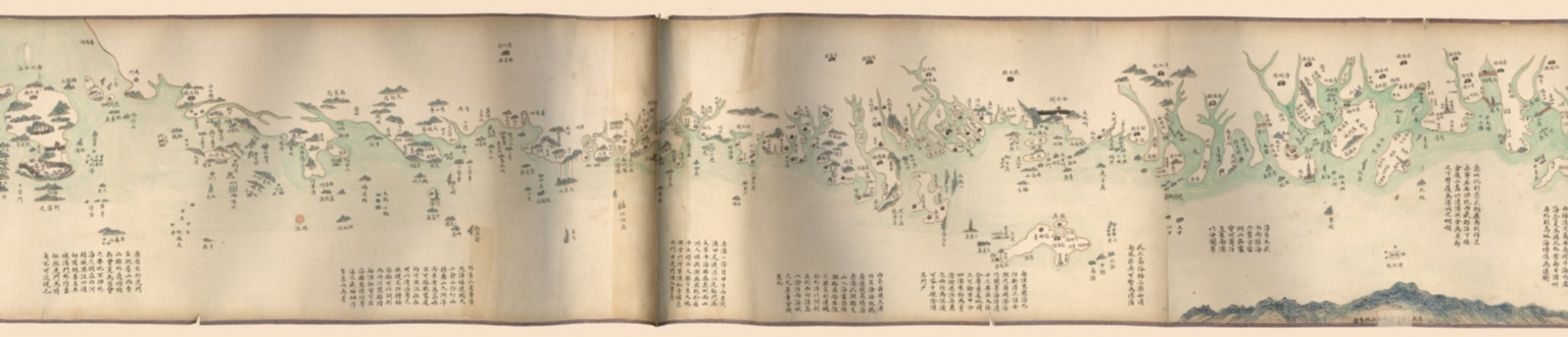
![[Carta náutica de Macau e das ilhas de Cantão]](http://lunamap.must.edu.mo:80/MediaManager/srvr?mediafile=/Size2/MUST~2~2/46/D89r.jpg)
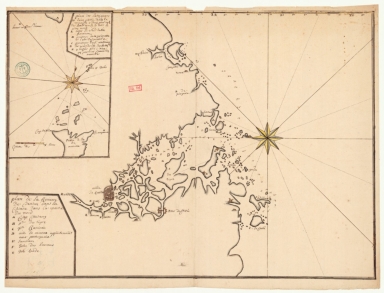
![Carte plate d'une partie de la coste de Chine, depuis les isles Pulo-Taya au nord est de l'isle de Haynam, et toutes les isles tant de la la partie de l'ouest que celles de l'e[st] servant de reconnoissance pour l'entrée de la rivière de Canton](http://lunamap.must.edu.mo:80/MediaManager/srvr?mediafile=/Size2/MUST~2~2/54/GE+SH+18+PF+179+DIV+9+P+9+-+Carte+plate+d%27une+partie+de+la+coste+de+Chine.jpg)
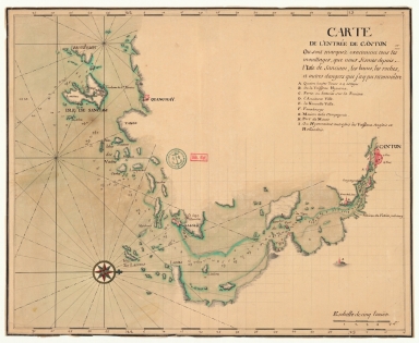
![[Tonquin, Quancy, Aynam]](http://lunamap.must.edu.mo:80/MediaManager/srvr?mediafile=/Size2/MUST~2~2/33/G2201.P5+H3+1690.jpg)