WHERE
|
Barcode
4687820500760
Title
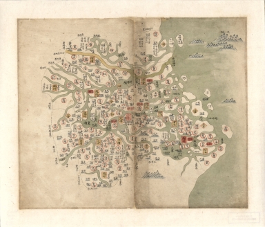
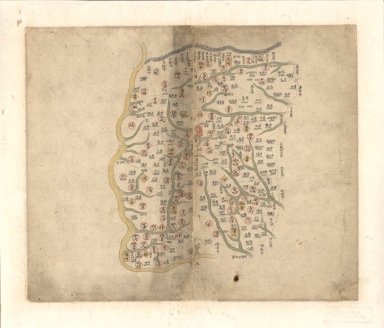
江南省輿圖 = Map of Jiangsu and Anhui Province
Contributor
Anonymous
Type
Manuscripts
Barcode
4687820500759
Title
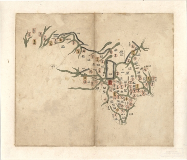
甘肅省輿圖 = Map of Gansu Province
Contributor
Anonymous
Type
Manuscripts
Barcode
4687820500758
Title
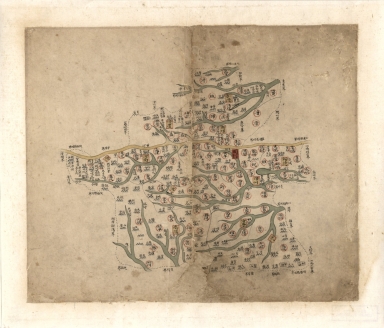
河南省輿圖 = Map of Henan Province
Contributor
Anonymous
Type
Manuscripts
Barcode
4687820500757
Title
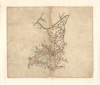
陝西省輿圖 = Map of Shaanxi Province
Contributor
Anonymous
Type
Manuscripts
Barcode
4687820500756
Title
山西省輿圖 = Map of Shanxi Province
Contributor
Anonymous
Type
Manuscripts
Barcode
4687820500755
Title
山東省輿圖 = Map of Shangdong Province
Contributor
Anonymous
Type
Manuscripts
Barcode
4687820500754
Title
盛京輿圖 = Map of Liaoning Province
Contributor
Anonymous
Type
Manuscripts
Barcode
4687820500770
Title
大清分省輿圖封面 = Cover : Provincial atlas of the great Qing Dynasty
Contributor
Anonymous
Type
Manuscripts
Barcode
4687820500753
Title
直隸省輿圖 = Map of Hebei Province
Contributor
Anonymous
Type
Manuscripts
Barcode
4687820500455
Title
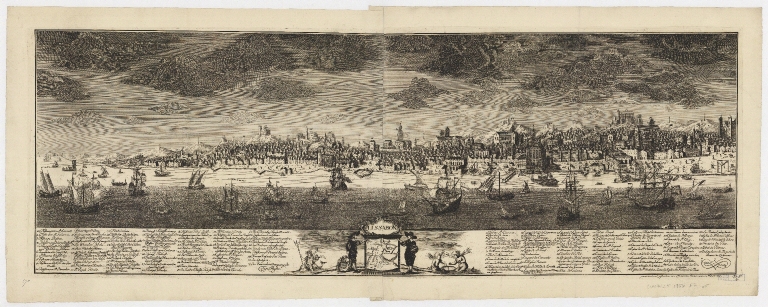
Erklärung des Kupferstiches von Lissabon
Contributor
Schoenemann, Friederich
Type
Printed
Barcode
4687820500302
Title
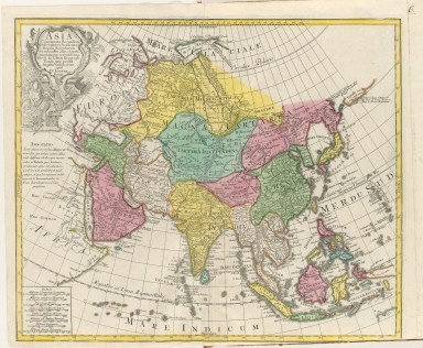
Asia : Concinnata Secundum Observationes Academiae Regalis Scientiarum et nonnullas alias, et iuxta annotationes recentissimas
Contributor
L'Isle, Guillaume de, 1675-1726
Type
Printed
Barcode
4687820500330
Title
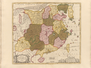
Imperii Sinarum nova descriptio
Contributor
Loon, J. van, approximately 1611-1686
Type
Printed
Barcode
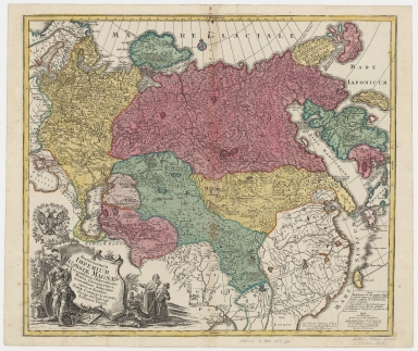
4687820500427
Title
Spatiosissimum Imperium Russiae magnae iuxta recentissimas observationes mappa geographica
Contributor
Lotter, Tobias Conrad, 1717-1777
Type
Printed
Barcode
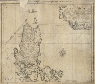
3687800354492G
Title
Carte hydrographique & chorographique des isles Philippines : dediée à Sa Majesté Catholique, par le Brigadier Don Ferdinand Valdes Tamon, Chevalier de l'ordre de S.t Jaques, Gouverneur & Capitaine Général des dites Isles, dressée par le R. Pere Pierre Murillo Velarde, de la C. de Gieusu sur les Cartes, les Rélations et les Navigations les plus exactes à Manille 1734 par ordre de Sa Majesté
Contributor
[Lowitz, Georg Moriz, 1722-1774, cartographer, Murillo Velarde, Pedro, 1696-1753, bibliografic antecedent, Bagay, Nicolás de la Cruz, 1701-1771, engraver, Valdés y Tamón, Fernando de, 1681-ca. 1741, dedicator, Charles III, King of Spain, 1716-1788, dedicatee, Homann Erben (Firm), publisher]
Type
Printed
Barcode
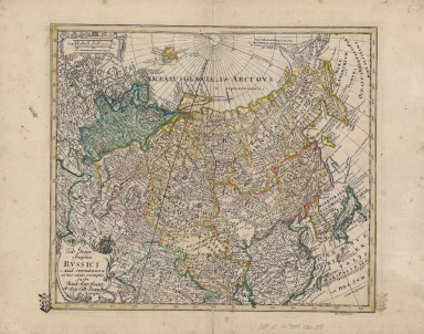
4687820500340
Title
Tab. Geogr. Imperii Russici : ad emendatiora adhuc edita exempla jussu Acad. Reg. Scient. et eleg. Litt. Boruss. descripta
Contributor
Euler, Leonhard, 1707-1783
Type
Printed
Barcode
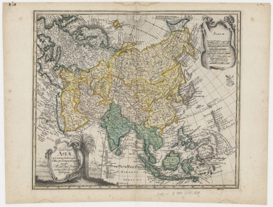
4687820500341
Title
Tab. geogr. Asiae : ad emendatiora, quae adhuc prodierunt, exempla jussu Acad. Reg. Scient. et eleg. Litt. Boruss. descripta
Contributor
Euler, Leonhard, 1707-1783
Type
Printed
Barcode
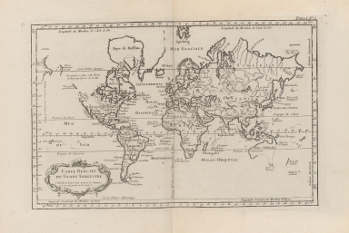
4687820500305
Title
Carte reduite du globe terrestre
Contributor
Bellin, Jacques Nicolas, 1703-1772
Type
Printed
Barcode
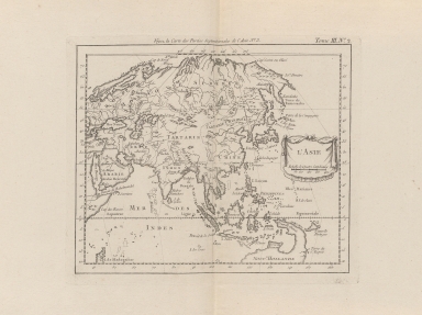
4687820500306
Title
L'Asie
Contributor
Bellin, Jacques Nicolas, 1703-1772
Type
Printed
Barcode
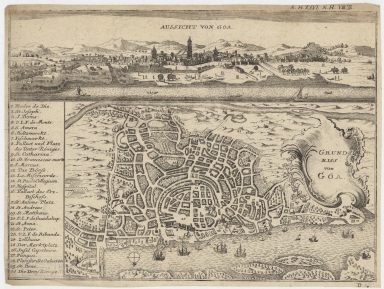
4687820500315
Title
Aussicht von Goa ; Grundriss von Goa
Contributor
Anonymous
Type
Printed
Barcode
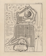
4687820500125
Title
Plan de la Ville de Malaca
Contributor
Bellin, Jacques Nicolas, 1703-1772
Type
Printed
Barcode
4687820500443
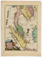
Title
Royaume de Siam, avec les royaumes qui luy sont tributaires, et les isles de Sumatra, Andemaon, etc.
Contributor
Coronelli, Vincenzo, 1650-1718
Type
Printed
Barcode
4687820501177
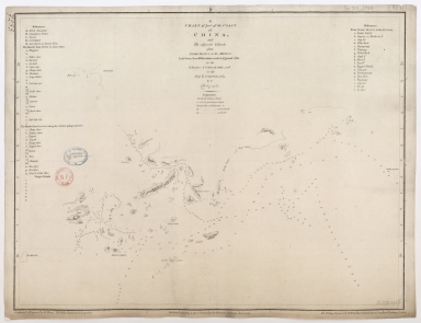
Title
A chart of part of the coast of China, and the adjacent islands from Pedro Blanco to the Mizen : laid down from observations made in 1759 and 1760, in the Schooner Cuddalore, and in the Ship London, 1764
Contributor
[Dalrymple, Alexander, 1737-1808, hydrographer, publisher, Henry, B., fl. 1770-1775, engraver, Lerpinière, Daniel, 1745-1785, engraver, Whitchurch, William, fl. 18th century, engraver, Lane, Bartholomew, fl. 19th century, engraver]
Type
Printed
Barcode
4687820501175
Title
A chart of the China Sea : inscribed to Mons.r d'Aprés de Mannevillette the ingenious author of the Neptune Oriental, as a tribute due to his labours for the benefit of navigation, and in acknowledgment of his many signal favours to A. Dalrymple.
Contributor
[Dalrymple, Alexander, 1737-1808, hydrographer, Henry, B., fl. 1770-1775, engraver, Whitchurch, William, fl. 18th century, engraver, Lane, Bartholomew, fl. 19th century, engraver, Après de Mannevillette, Jean-Baptiste-Nicolas-Denis d', 1707-1780, dedicatee]
Type
Printed
Barcode
36878003712158
Title
Mappa da barra de Macáo
Contributor
Rendo, Custódio de Azevedo, cartographer
Type
Printed
Barcode
4687820500058
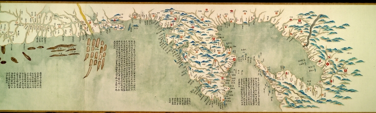
Title
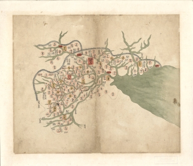
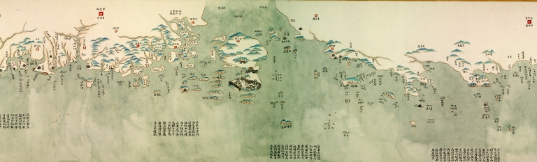
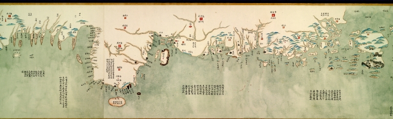
中華沿海形勢全圖. Part 1
Contributor
Anonymous
Type
Manuscripts
Barcode
4687820500068
Title
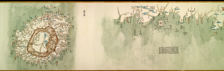
中華沿海形勢全圖. 澳門地區圖
Contributor
Anonymous
Type
Manuscripts
Barcode
4687820500067
Title
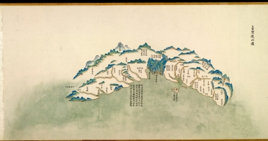
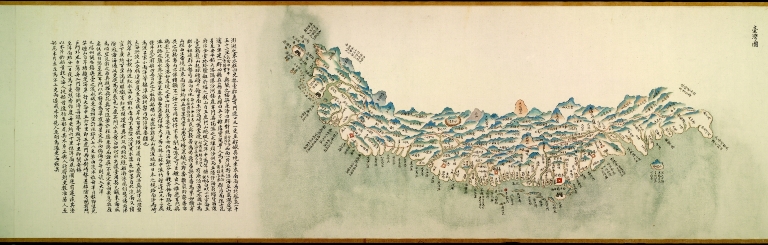
中華沿海形勢全圖. Part 10
Contributor
Anonymous
Type
Manuscripts
Barcode
4687820500065
Title
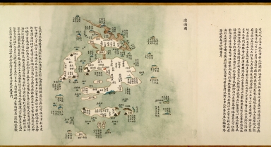
中華沿海形勢全圖. Part 8
Contributor
Anonymous
Type
Manuscripts
Barcode
4687820500064
Title
中華沿海形勢全圖. Part 7
Contributor
Anonymous
Type
Manuscripts
Barcode
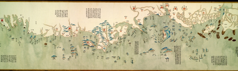
4687820500059
Title
中華沿海形勢全圖. Part 2
Contributor
Anonymous
Type
Manuscripts
Barcode
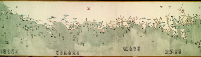
4687820500060
Title
中華沿海形勢全圖. Part 3
Contributor
Anonymous
Type
Manuscripts
Barcode
4687820500062
Title
中華沿海形勢全圖. Part 5
Contributor
Anonymous
Type
Manuscripts
Barcode
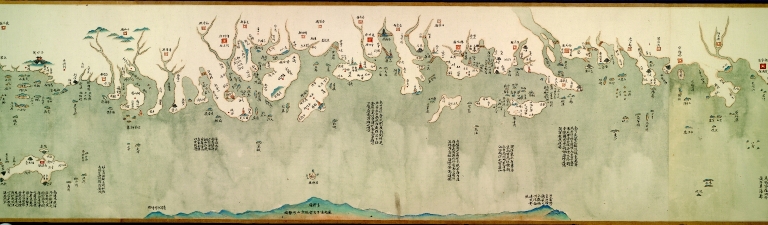
4687820500061
Title
中華沿海形勢全圖. Part 4
Contributor
Anonymous
Type
Manuscripts
Barcode
4687820500063
Title
中華沿海形勢全圖. Part 6
Contributor
Anonymous
Type
Manuscripts
Barcode
4687820500066
Title
中華沿海形勢全圖. Part 9
Contributor
Anonymous
Type
Manuscripts
Barcode
4687820500211
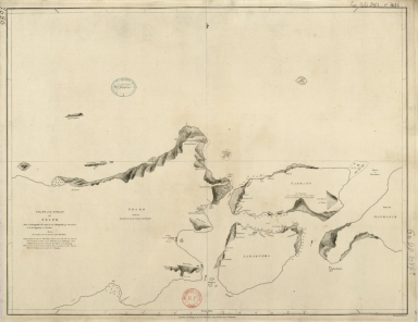
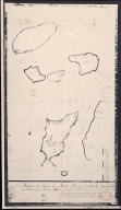
Title
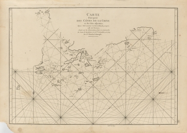
Carte d'une partie des côtes de la Chine et des Isles adjacentes : depuis l'Isle nommée la Pierre Blanche, jusqu'a celle de l'Artimon
Contributor
Dalrymple, Alexander, 1737-1808
Type
Printed
Barcode
4687820500444
Title
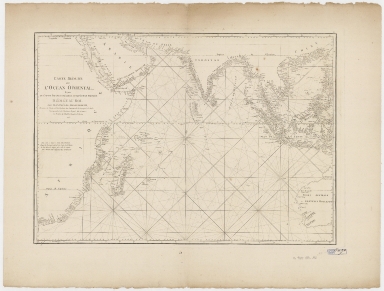
Carte réduite de l'ocean oriental depuis le Cap de Bonne Espérance jusqu'à l'isle Formose
Contributor
Après de Mannevillette, Jean-Baptiste-Nicolas-Denis d', 1707-1780
Type
Printed
Barcode
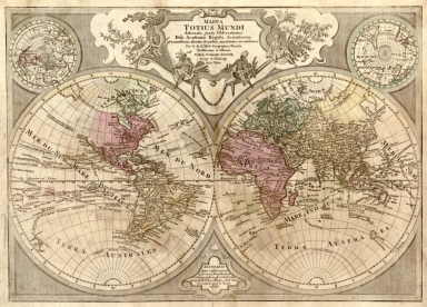
4687820500580
Title
Mappa totius mundi : adornata juxta observationes dnn. academiae regalis scientiarum et nonnullorum aliorum secundum annotationes recentissimas
Contributor
[L'Isle, Guillaume de, 1675-1726, Lotter, Tobias Conrad, 1717-1777]
Type
Printed
Barcode
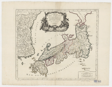
4687820500398
Title
L'empire du Japon : divisé en sept principales parties, savoir, Ochio, Quanto, Jetsegen, Jetsen, Jamaisoit, Xicoco et Ximo, et subdivisé en soixante et six royaumes
Contributor
[Robert de Vaugondy, Didier, 1723-1786, Remondini, Giuseppe Antonio, 1747-1811]
Type
Printed
Barcode
4687820500782
Title
A chart of the East India Islands with the coasts of the continent from Caliminera Point to Amoye in China
Contributor
Anonymous
Type
Printed
Barcode
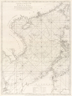
4687820500783
Title
A general chart of the China Sea : drawn from the journals of the European navigators, particularly from those collected by Capt. Hayter
Contributor
Anonymous
Type
Printed
Barcode
4687820500348
Title
Mapa que demuestra el derrotero q[ue] : hizo M. Cook en 1776, 1777, 1778, y 1779 en su tercero y ultimo viaje
Contributor
Anonymous
Type
Printed
Barcode
4687820500654
Title
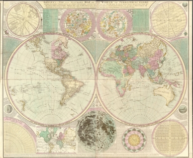
Bowles's new and accurate map of the world, or Terrestrial globe : laid down from the best observations and newest discoveries particularly those lately made in the south seas by Anson, Byron, Wallis, Bouganville, Cook, and other celebrated circumnavigators, illustrated with a variety of useful projections and representations of the heavenly bodies the most approved astronomical and geographical definitions tables, and problems with an easy and familiar explanation of the most curious and interesting phoenomena in the universal system
Contributor
Bowles, Carington, 1724-1793
Type
Printed
Barcode
4687820500790
Title
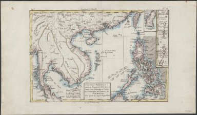
Les isles Philippines, celle de Formose, le sud de la Chine, les royaumes de Tunkin, de Cochinchine, de Camboge, de Siam, des Laos, avec partie de ceux de Pegu et d'Ava
Contributor
Bonne, Rigobert, 1727-1794
Type
Manuscripts
Barcode
4687820500137
Title
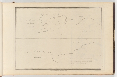
Plan of the Typa near Macao in China
Contributor
Baker, George, 1781-1851, cartographer
Type
Printed
Barcode
3687800354652E
Title
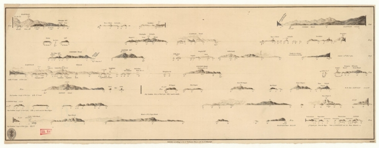
Views of the coasts of China
Contributor
[Great Britain. Hydrographic Office, author, Dalrymple, Alexander, 1737-1808, publisher]
Type
Printed
Barcode
4687820501197
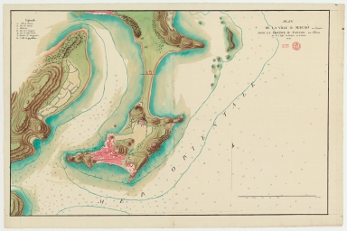
Title
Plan de la ville de Macaô aux Portugais dans la province de Canton en Chine
Contributor
Lafitte de Brassier, Louis François Grégoire, 1745-17..?
Type
Manuscripts
Barcode
4687820501171
Title
Chart of the Strait of Solor : from a Portuguese ms used by the Portuguese of Macao in the navigation to Timor
Contributor
[Harmer, Thomas, fl. 1784-1814, engraver, Dalrymple, Alexander, 1737-1808, publisher]
Type
Printed
Barcode
3687800354209C
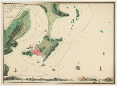
Title
Plan de la ville de Macao, et de ses environs aux Portugais
Contributor
Lafitte de Brassier, Louis François Grégoire, 1745-17--, cartographer
Type
Manuscripts
Barcode
4687820500023
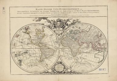
Title
Mappe-monde géo-hydrographique, ou, description générale du globe terestre et aquatique : en deux plans-hémispheres où son exactement remarqueés en général toutes les parties de la terre et de l’eau suivant les relations les plus nouvelles
Contributor
[Jaillot, Alexis Hubert, 1632?-1712, Brion de la Tour, Louis, 1743-1803, Desnos, Louis-Charles, 1725-1805]
Type
Printed
|


![Mapa que demuestra el derrotero q[ue] : hizo M. Cook en 1776, 1777, 1778, y 1779 en su tercero y ultimo viaje](http://lunamap.must.edu.mo:80/MediaManager/srvr?mediafile=/Size1/MUST~2~2/22/G9231_S12_1780_L5.jpg)