WHERE
|
Barcode
4687820500284
Title
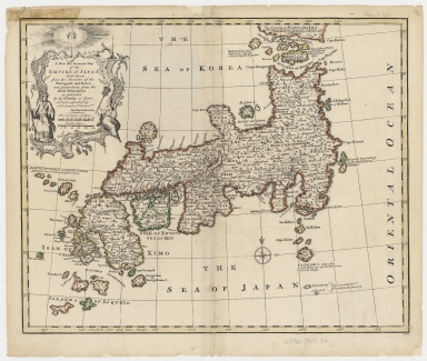
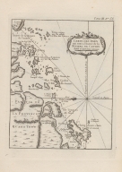
A new and accurate map of the Empire of Japan : laid down from the memoirs of the Portuguese and Dutch, and particularly from the Jesuit missionaries, as publish'd by the Sr. Bellin at Paris, being adjusted by astronomical observat.ns
Contributor
Bowen, Emanuel, ca. 1693-1767, engraver
Type
Printed
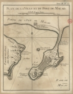
Barcode
4687820500658
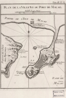
Title
Plan de la ville et du port de Macao
Contributor
Bellin, Jacques-Nicolas, 1703-1772, cartographer
Type
Printed
Barcode
4687820500498
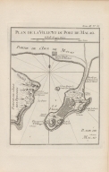
Title
Plan de la ville et du port de Macao
Contributor
Bellin, Jacques-Nicolas, 1703-1772, cartographer
Type
Printed
Barcode
4687820500010
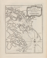
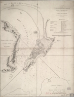
Title
Carte de l'entrée de la riviere de Canton dans la Chine
Contributor
Bellin, Jacques-Nicolas, 1703-1772, cartographer
Type
Printed
Barcode
4687820500008
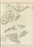
Title
Carte des Isles qui sont a l'entrée de la riviere de Canton
Contributor
Bellin, Jacques-Nicolas, 1703-1772, cartographer
Type
Printed
Barcode
4687820500202
Title
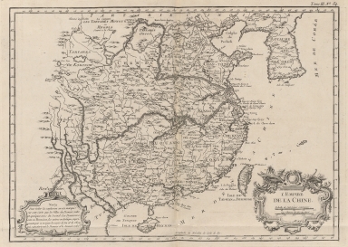
L'Empire de la Chine
Contributor
Bellin, Jacques-Nicolas, 1703-1772, cartographer
Type
Printed
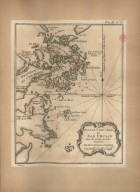
Barcode
3687800354418E
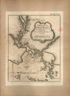
Title
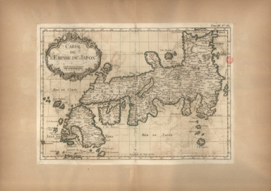
Carte de l'Empire du Japon
Contributor
Bellin, Jacques-Nicolas, 1703-1772, cartographer
Type
Printed
Barcode
3687800354419F
Title
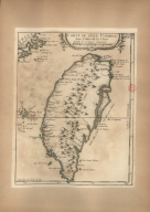
Carte de l'Isle Formose aux costes de la Chine
Contributor
Bellin, Jacques-Nicolas, 1703-1772, cartographer
Type
Printed
Barcode
3687800354423A
Title
Carte de la Baye d'Hocsieu et des entrées de la riviere de Chang, dans la Province de Fokyen, en Chine
Contributor
Bellin, Jacques-Nicolas, 1703-1772, cartographer
Type
Printed
Barcode
36878003544218
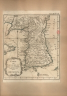
Title
Carte du royaume de Kau-li ou Corée : copiée sur la Carte Angloise
Contributor
Bellin, Jacques-Nicolas, 1703-1772, cartographer
Type
Printed
Barcode
3687800354416C
Title
Carte de l'entrée de la riviere de Canton dans la Chine
Contributor
Bellin, Jacques-Nicolas, 1703-1772, cartographer
Type
Printed
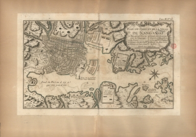
Barcode
3687800354425C
Title
Plan du port et de la ville de Nangasaki
Contributor
Bellin, Jacques-Nicolas, 1703-1772, cartographer
Type
Printed
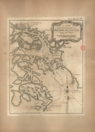
Barcode
36878003544229
Title
Isle de Cheu-Chan ou Isle Chusan avec les costes et isles voisines
Contributor
Bellin, Jacques-Nicolas, 1703-1772, cartographer
Type
Manuscripts
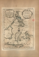
Barcode
3687800354414A
Title
Carte des Isles Philippines Celebes et Moluques
Contributor
Bellin, Jacques-Nicolas, 1703-1772, cartographer
Type
Printed
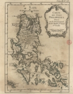
Barcode
3687800354454E
Title
Carte des Isles Philippines : dressée sur la carte espagnole du R.P. Murillo de Velarde I.re feville
Contributor
[Bellin, Jacques-Nicolas, 1703-1772, cartographer, Murillo Velarde, Pedro, 1696-1753, bibliographic antecedent]
Type
Printed
Barcode
3687800371219C
Title
Plan de la ville et du port de Macao
Contributor
Bellin, Jacques-Nicolas, 1703-1772, cartographer
Type
Printed
Barcode
3687800354681G
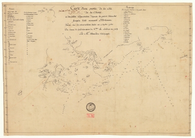
Title
Carte d'une partie de la côte de la Chine et des îles adjacentes depuis la pierre blanche jusqu'à l'isle nommée l'Artimon tracée sur les observations faites en 1759 & 1760 du senau Le Goudelours du v.au Le Londres en 1764
Contributor
Dalrymple, Alexander, 1737-1808, cartographer
Type
Manuscripts
Barcode
4687820500218
Title
A chart of the China Sea : inscribed to Mons.r D'Aprés de Mannevillette the ingenious author of the Neptune Oriental, as a tribute due to his labours for the benefit of Navigation, and in acknowledgement of his many signal favours to Dalrymple.
Contributor
[Dalrymple, Alexander, 1737-1808, hydrographer, Demonville, Antoine Guénard, ca. 1733-1797, printer, Malassis, Romain-Nicolas, 1737-1813, printer, Après de Mannevillette, Jean-Baptiste-Nicolas-Denis d', 1707-1780, dedicatee]
Type
Printed
Barcode
36878003542148
Title
Sketch of the Typa and Macao
Contributor
[Harrison, William, 17---ca. 18--, Nicol, George, ca. 1740-1828, publisher, Cadell, Thomas, 1742-1802, publisher]
Type
Printed
Barcode
4687820500663
Title
A plan of the city and harbour of Macao : a colony of the Portugueze situated at the southern extremity of the Chinese Empire in Lat. 22 ⁰12ʹ44ʺ N., Long. 113⁰35ʹ0ʺ east of Greenwich
Contributor
Baker, Benjamin, fl. 1766-1824, cartographer
Type
Printed
Barcode
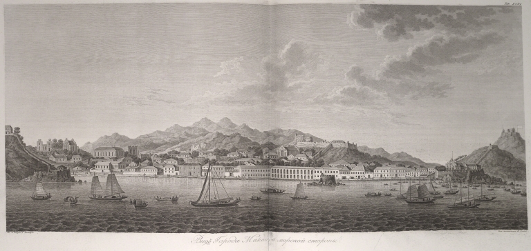
36878003712147
Title
View of the city of Macau from the sea side
Contributor
[Tilesius von Tilenau, Wilhelm Gottlieb, 1769-1857, author, Maritime Printing House, printer]
Type
Printed
Barcode
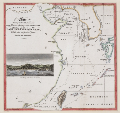
4687820500852
Title
Chart shewing the track & discoveries of his Majesty's ships Alceste & Lyra, in the Eastern & Yellow Seas, with the adjacent parts from the best authorities.
Contributor
[Murray, John, 1778-1843, author, printer, Dwarris, Fortunatus, Sir, 1786-1860, illustrator]
Type
Printed
Barcode
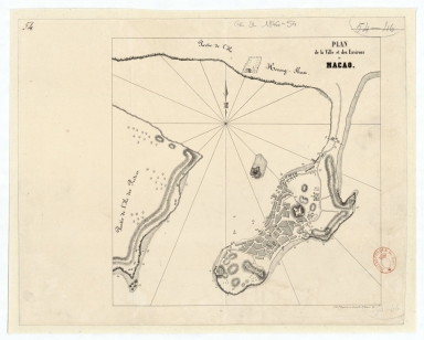
4687820501168
Title
Plan de la ville et des environs de Macao
Contributor
Dupont, Paul-François, 1796-1879, lithographer
Type
Manuscripts
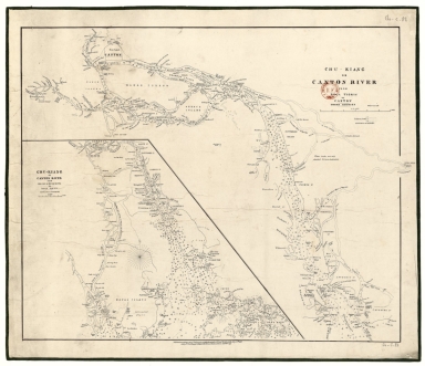
Barcode
3687800354609G
Title
Chu-Kiang or Canton River from Boca Tigris to Canton
Type
Manuscript
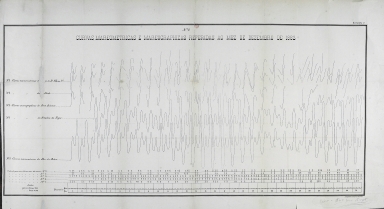
Title
Curvas mareometricas e mareographicas referidas ao mez de Dezembro de 1883. N.º 2
Contributor
Portugal. Imprensa Nacional, Litografia, publisher
Type
Printed
Title
[Fundos do porto de Macau e curvas pluviométricas]
Contributor
Portugal. Imprensa Nacional, Litografia, publisher
Type
Printed
Title
[Curvas de marés e perfis instantâneos entre ilhas]
Contributor
Portugal. Imprensa Nacional, Litografia, publisher
Type
Printed
Title
[Curvas das pressões barométricas, dos prea-mares e baixa-mares e observações dos ventos]
Contributor
Portugal. Imprensa Nacional, Litografia, publisher
Type
Printed
Barcode
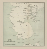
3687800354433B
Title
Carte de la baie de Kouang-Tchéou-Wan et de la presqu'ile de Leï-Tchéou
Contributor
L.L. Poates Engr'g Co., printer
Type
Printed
Barcode
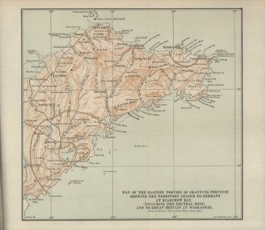
36878003544308
Title
Map of the Eastern portion of Shantung Province showing the territory leased to Germany at Kiaochow Bay (including the neutral zone) and to Great Britain at Weihaiwei : (from Ch. Waeber's Map of North Eastern China, 1900)
Contributor
[Veber, Karl Ivanovič, 1841-1910, bibliographic antecedent, L.L. Poates Engr'g Co., printer]
Type
Printed
Barcode
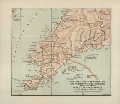
3687800354428F
Title
Territory leased to Russia (1898) and subsequently transferred to Japan (1905) in the Liaotung Peninsula (including the neutral zone) : (from Ch. Waeber's Map of North Eastern China, 1900).
Contributor
[Veber, Karl Ivanovič, 1841-1910, bibliographic antecedent, L.L. Poates Engr'g Co., printer]
Type
Printed
Barcode
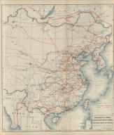
36878003544319
Title
Railway map of China : Peking, Oct. 1918
Contributor
[United States. Bureau of Foreign and Domestic Commerce, author, Whitham, Paul Page, 1878-1941, author, L.L. Poates Engr'g Co., printer]
Type
Printed
Barcode
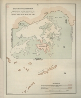
3687800354432A
Title
Hong Kong extension : reproduction of the map attached to the Convention between Great Britain and China signed at Peking on the 9th of June 1898.
Contributor
L.L. Poates Engr'g Co., printer
Type
Printed
Barcode
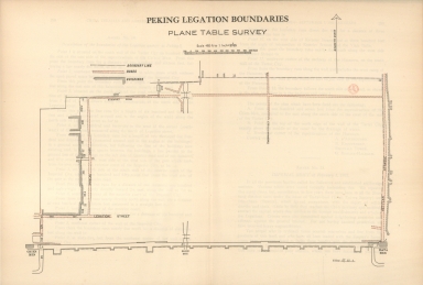
3687800354435D
Title
Peking legation boundaries : plane table survey.
Type
Printed
Barcode
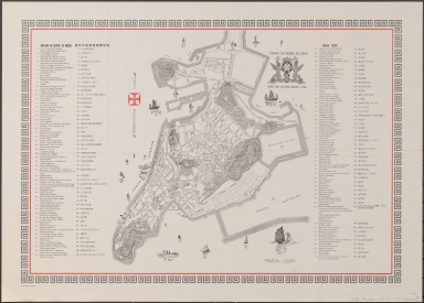
3687800371238D
Title
Roteiro da cidade de Macau = Macao guide = 澳門市遊覽指南圖説明.
Contributor
[Portugal. Imprensa Nacional, Litografia, publisher, Braga, José Maria, 1897-1988, former owner]
Type
Printed
Barcode
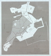
36878003712439
Title
Macau and vicinity
Contributor
United States. Army Map Service, author
Type
Printed
Barcode
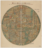
3687800285630D
Title
Ebstorf mappamundi
Contributor
[Gervase, of Tilbury, ca. 1160-ca. 1211, cartographer, Miller, Konrad, 1844-1933, editor, Eckstein & Stähle, publisher]
Type
Printed
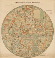
Barcode
3687800354588M
Title
Ebstorf Map
Contributor
[Gervase, of Tilbury, ca. 1160-ca. 1211, cartographer, Miller, Konrad, 1844-1933, editor, Eckstein & Stähle, publisher]
Type
Printed
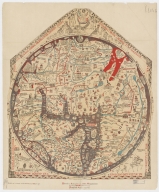
Barcode
36878002400386
Title
Hereford Mappa Mundi
Contributor
Ricardus, de Bello, fl. 1276-1312, cartographer
Type
Printed
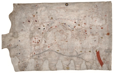
Barcode
4687820501068
Title
Nautical chart of the Eastern Atlantic Ocean, Mediterranean Sea, Black Sea and Red Sea
Contributor
Soler, Guillem, fl.1380-1385, cartographer
Type
Manuscripts
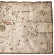
Barcode
3687800354662F
Title
Nautical chart of the Mediterranean Sea and the Black Sea
Contributor
Roselli, Pietro, fl. 1446-1489, cartographer
Type
Manuscripts
Barcode
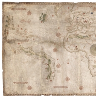
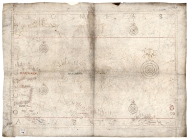
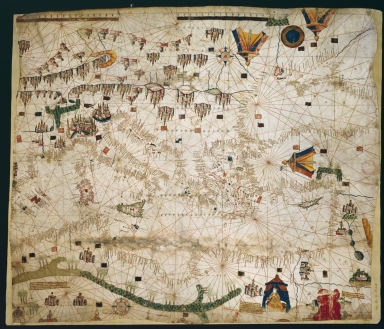
3687800354085E
Title
[Portolan chart]
Type
Manuscripts
Barcode
3687800354663G
Contributor
Caverio, Nicolo di, fl. 1502, cartographer
Type
Manuscripts
Barcode
687800354663G
Contributor
Caverio, Nicolo di, fl. 1502, cartographer
Type
Manuscripts
Barcode
36878003546108
Title
Disc of 495 mm diameter
Contributor
Homem, Diogo, ca. 1520-1576, cartographer
Type
Manuscripts
Barcode
36878003546119
Title
Disc of 460 mm diameter.
Contributor
Homem, Diogo, ca. 1520-1576, cartographer
Type
Manuscripts
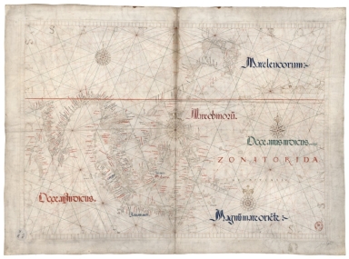
Barcode
3687800354613B
Title
Mediterranean Sea, Black Sea, Caspian Sea, Red Sea, Persian Gulf and small part of the Bay of Bengal
Contributor
Homem, Diogo, ca. 1520-1576, cartographer
Type
Manuscripts
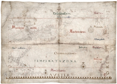
Barcode
687800354612A
Title
North Indian Ocean, China Sea and part of the Pacific Ocean
Contributor
Homem, Diogo, ca. 1520-1576, cartographer
Type
Manuscripts
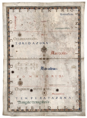
Barcode
3687800354615D
Title
North Atlantic Ocean
Contributor
Homem, Diogo, ca. 1520-1576, cartographer
Type
Manuscripts
|

![[Fundos do porto de Macau e curvas pluviométricas]](http://lunamap.must.edu.mo:80/MediaManager/srvr?mediafile=/Size2/MUST~2~2/325/3687800363939M%28503752_6_t0%29.jpg)
![[Curvas de marés e perfis instantâneos entre ilhas]](http://lunamap.must.edu.mo:80/MediaManager/srvr?mediafile=/Size2/MUST~2~2/325/3687800363715E%28503752_3_t0%29.jpg)
![[Curvas das pressões barométricas, dos prea-mares e baixa-mares e observações dos ventos]](http://lunamap.must.edu.mo:80/MediaManager/srvr?mediafile=/Size2/MUST~2~2/325/3687800363937K%28503752_4_t0%29.jpg)
![[Portolan chart]](http://lunamap.must.edu.mo:80/MediaManager/srvr?mediafile=/Size2/MUST~2~2/45/000651.jpg)