|
Barcode
4687820500558
Title
海疆洋界形勢全圖.Part 6 = Coastal map of China.Part 6
Contributor
Anonymous
Type
Manuscripts
Barcode
4687820500564
Title
海疆洋界形勢圖.Part 6
Contributor
Hummel, Arthur W. (Arthur William), 1884-1975
Type
Manuscripts
Barcode
36878003222312
Title
To the Society of Managing Owners of the Ships in the English East India Company's Service, This Chart of the China Sea, Including the Philippina Molluca and Banda Islands, Shewing al the same time all the Tracks into the Pacific Ocean, commonly known by the name of the Eastern Passage to China
Contributor
[Robertson, George, 1748-1788, cartographer, Harmer, Thomas, fl. 1784-1814, engraver]
Type
Printed
Barcode
4687820500989
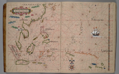
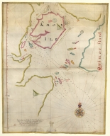
Title
[Plan of Mirs Bay on the coast of China, Chart of the island Lamock, Lamon, Plan of Ping Hai Bay]
Contributor
Murphy, Edward
Type
Manuscripts
Barcode
3687800301756B
Title
A new chart of the oriental seas and islands with the coasts of the continent from the Isle of Ceylon to Amoye in China
Contributor
[Après de Mannevillette, Jean-Baptiste-Nicolas-Denis d', 1707-1780, cartographer, Laurie & Whittle, publisher]
Type
Printed
Barcode
4687820500208
Title
Carte du Grand Océan ou Mer du Sud : dressée pour la Relation du voyage de découvertes faites par les frégates françaises la Boussole et l'Astrolabe dans les années 1785, 86, 87, et 88
Contributor
La Pérouse, Jean-François de Galaup, comte de, 1741-1788
Type
Printed
Barcode
4687820500131
Title
Carte des côtes de l'Amérique et de l'Asie : depuis la Californie jusqu'à Macao
Contributor
La Pérouse, Jean-François de Galaup, comte de, 1741-1788
Type
Printed
Barcode
4687820501174
Title
Carte d'une partie de la mer de Chine
Contributor
Rosili Mesros, François Etienne de, 1748-1832, bibliographic antecedent
Type
Printed
Barcode
3687800354287I
Title
To the Honorable the Court of Directors of the United Company of Merchants of England trading to the East Indies, this Chart of the China Seas
Contributor
[Heather, William, 1764-1812, hydrographer, Stephenson, John,, fl. 1791-1817, engraver, Norie, John William, 1772-1843, illustrator, Heather and Williams, publisher]
Type
Printed
Barcode
4687820500373
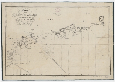
Title
Chart of the coast of China to the eastward of the great Ladrone
Contributor
[Ross, Daniel, 1780-1849, cartographer, Horsburgh, James, 1762-1836, publisher]
Type
Printed
Barcode
4687820500855
Title
Map of the western Pacific ocean and the Asiatic coast
Contributor
Anonymous
Type
Printed
Barcode
4687820500450
Title
To John Reeves Esq.re F.R.S. for the liberal aid of his Chinese m.s.s. and the benefit derived from his excellent map of that Empire presented by him to the Hon.ble East India Company this Chart of the East Coast of China
Contributor
[Horsburgh, James, 1762-1836, author, publisher, J. & C. Walker (Firm), engraver, Ross, Daniel, 1780-1849, cartographer, Hall, Basil, 1788-1844, cartographer, Crawford, James H., fl. 18--, cartographer, Rancliffe, George Augustus Henry Anne Parkyns, Baron, 1785-1850, cartographer, Rees, Thomas, 1790-1870, cartographer, Dayot, Félix, 1772-1821, cartographer, Sturgis, Josiah, 1773-1850, cartographer, Rees, John, 1752-18--, cartographer, Hoskiaer, Jacob, 1808-1836, cartographer, Dalrymple, Alexander, 1737-1808, bibliographic antecedent, Reeves, John, 1774-1856, dedicatee]
Type
Printed
Barcode
4687820500547
Title
七省沿海全圖
Contributor
[Jin, Baoyi, active 19th century, Hummel, Arthur W. (Arthur William), 1884-1975]
Type
Manuscripts
Barcode
4687820500604
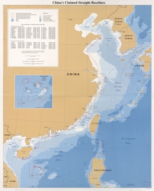
Title
China's claimed straight baselines
Contributor
United States. Central Intelligence Agency
Type
Printed
Barcode
3687800354088H
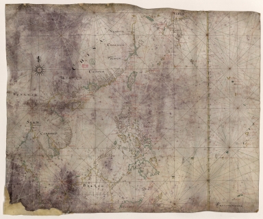
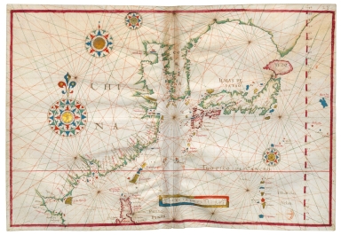
Title
[Southeast China, Japan, East Indies (northern part)]
Contributor
[Dourado, Fernão Vaz, 1520-1580, cartographer, Huth, Henry, 1815–1878, former owner]
Type
Manuscripts
Barcode
4687820501012
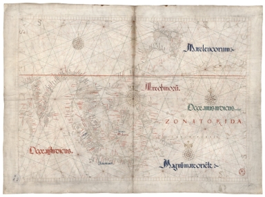
Title
[Indian Ocean from the Cape of Good Hope to Banda and from the Black Sea to Japan, Arabia, Persia, India, Indo-china and Insulinde, South China, Japan]
Contributor
Angelus, author
Type
Manuscripts
Barcode
4687820500914
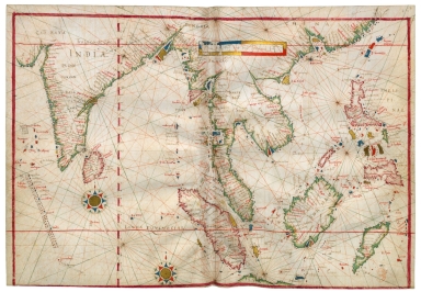
Title
[East Indies, including a large "Java Maior" (Australia?) and coast of Asia]
Contributor
[Oliva, Bartolomeo, 1538-1588, cartographer, Phillipps, Thomas, Sir, 1792-1872, former owner]
Type
Manuscripts
Barcode
4687820501093
Title
Neat outline of the Beijing river in China located in the Indian Sea
Type
Manuscripts
Barcode
36878003545017
Title
[Carte française de la Mer de Chine et du Golfe de Siam]
Type
Manuscripts
Barcode
3687800354567J
Title
[Chart of the Sea of Canton to Cambodia and the Philippines]
Type
Manuscripts
Barcode
3687800239892M
Title
[Asia]
Contributor
Albernaz, João Teixeira, fl. 1602-1649, cartographer
Type
Manuscripts
Barcode
3687800354648J
Title
Chart of the Pacific Ocean
Contributor
Albernaz, João Teixeira, I, fl. 1602-1649, cartographer
Type
Manuscripts
Barcode
3687800317483F
Title
Dutch Chart of the China Sea
Type
Manuscripts
Barcode
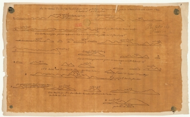
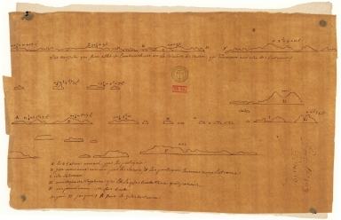
4687820501260
Title
[Vues de cotes des mers de Chine]. 1.er
Contributor
Surville, Jean-François de, 1717-1770, author
Type
Manuscripts
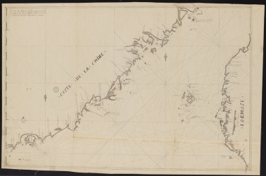
Barcode
3687800354261A
Title
Carte de côte de la Chine depuis les 22.e jusqu'au 25.e 30.m de latitude nord comprenant la partie de Ouest de l'Isle Formose
Type
Manuscripts
Barcode
3687800317478J
Title
Dutch nautical chart of the 18th century, including the coasts of Annam, Tonkin, China, Hainan Island and part of Luzon
Contributor
Saffroy, Amand, 1844-1905, former owner
Type
Manuscripts
Barcode
3687800354683I
Title
Views of the islands at the entrance to the Canton River
Type
Manuscripts
Barcode
3687800354680F
Title
Views of the islands at the entrance to the Canton River
Type
Manuscripts
Barcode
4687820500218
Title
A chart of the China Sea : inscribed to Mons.r D'Aprés de Mannevillette the ingenious author of the Neptune Oriental, as a tribute due to his labours for the benefit of Navigation, and in acknowledgement of his many signal favours to Dalrymple.
Contributor
[Dalrymple, Alexander, 1737-1808, hydrographer, Demonville, Antoine Guénard, ca. 1733-1797, printer, Malassis, Romain-Nicolas, 1737-1813, printer, Après de Mannevillette, Jean-Baptiste-Nicolas-Denis d', 1707-1780, dedicatee]
Type
Printed
Barcode
687800354612A
Title
North Indian Ocean, China Sea and part of the Pacific Ocean
Contributor
Homem, Diogo, ca. 1520-1576, cartographer
Type
Manuscripts
Barcode
4687820500976
Title
North China Sea and West Pacific Ocean
Contributor
Albernaz, João Teixeira, fl. 1602-1649, cartographer
Type
Manuscripts
Barcode
4687820500981
Title
East Indian Ocean and China Sea
Contributor
Albernaz, João Teixeira, fl. 1602-1649, cartographer
Type
Manuscripts
Barcode
4687820501030
Title
[Carte de l'Océan Indien, des cotes de l'Afrique et de l'Asie depuis le cap de Bonne-Espérance jusqu'au Japon]
Contributor
Albernaz, João Teixeira, fl. 1602-1649, cartographer
Type
Manuscripts
Barcode
3687800317471C
Title
A new and correct chart of the coast of China : from latitude 12° north to 26° including Formosa, Hayman and the Philippine Islands.
Contributor
W. and J. Mount, T. and T. Page, 1747-1763, publisher, bookseller
Type
Printed
Barcode
3687800354570D
Title
English chart of the island of Amoy
Contributor
Thornton, John, 1641-1708, cartographer
Type
Manuscripts
Barcode
3687800354661E
Title
Chart of the coasts of China from Hainan Island to Guangzhou
Type
Manuscripts
Barcode
3687800354509F
Title
Map of the coasts of China and neighboring islands with some additions
Contributor
Anville, Jean Baptiste Bourguignon d', 1697-1782, cartographer
Type
Printed
Barcode
3687800354508E
Title
Map of the coasts of China and neighboring islands with some additions
Contributor
Anville, Jean Baptiste Bourguignon d', 1697-1782, cartographer
Type
Manuscripts
Barcode
3687800354286H
Title
[Carte d'une partie de la mer de Chine]
Type
Manuscripts
|

![[Plan of Mirs Bay on the coast of China, Chart of the island Lamock, Lamon, Plan of Ping Hai Bay]](http://lunamap.must.edu.mo:80/MediaManager/srvr?mediafile=/Size2/MUST~2~2/54/GE+SH+18+PF+179+DIV+14+P+1+D+-+Plan+of+Mirs+Bay+on+the+coast+of+China+-+Plan+of+Ping+Hai+Bay.jpg)


![[Southeast China, Japan, East Indies (northern part)]](http://lunamap.must.edu.mo:80/MediaManager/srvr?mediafile=/Size2/MUST~2~2/45/000434.jpg)
![[Indian Ocean from the Cape of Good Hope to Banda and from the Black Sea to Japan, Arabia, Persia, India, Indo-china and Insulinde, South China, Japan]](http://lunamap.must.edu.mo:80/MediaManager/srvr?mediafile=/Size2/MUST~2~2/54/FRANCAIS+9669+-+fol+8v-9.jpg)
![[East Indies, including a large "Java Maior" (Australia?) and coast of Asia]](http://lunamap.must.edu.mo:80/MediaManager/srvr?mediafile=/Size2/MUST~2~2/45/000358.jpg)
![[Carte française de la Mer de Chine et du Golfe de Siam]](http://lunamap.must.edu.mo:80/MediaManager/srvr?mediafile=/Size1/MUST~2~2/63/GE+SH+18+PF+181+P+9+RES+-+Carte+fran%C3%83%C2%A7aise+de+la+Mer+de+Chine+et+du+Golfe+de+Siam.jpg)
![[Chart of the Sea of Canton to Cambodia and the Philippines]](http://lunamap.must.edu.mo:80/MediaManager/srvr?mediafile=/Size2/MUST~2~2/54/GE+SH+18+PF+181+P+21+RES+Carte+des+mers+de+Canton.jpg)
![[Asia]](http://lunamap.must.edu.mo:80/MediaManager/srvr?mediafile=/Size2/MUST~2~2/41/G1015+.T4+1630-12.jpg)
![[Vues de cotes des mers de Chine]. 1.er](http://lunamap.must.edu.mo:80/MediaManager/srvr?mediafile=/Size1/MUST~2~2/54/GE+SH+18+PF+183+DIV+1+P+1+%28PL+1%29.jpg)


![[Carte de l'Océan Indien, des cotes de l'Afrique et de l'Asie depuis le cap de Bonne-Espérance jusqu'au Japon]](http://lunamap.must.edu.mo:80/MediaManager/srvr?mediafile=/Size2/MUST~2~2/54/GE+SH+18+PF+213+DIV+3+P+2-2.jpg)


![[Carte d'une partie de la mer de Chine]](http://lunamap.must.edu.mo:80/MediaManager/srvr?mediafile=/Size2/MUST~2~2/54/GE+SH+18+PF+182+P+11+D_Carte+d%27une+partie+de+la+mer+de+Chine.jpg)