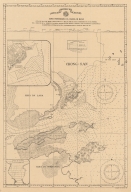
|
Barcode
4687820500123
Title
Carte du port de Goa et ses environs
Contributor
Bellin, Jacques-Nicolas, 1703-1772, cartographer
Type
Printed
Barcode
4687820500326
Title
Isola del Giappone e penisola di Corea
Contributor
[Coronelli, Vincenzo, 1650-1718, cartographer, Padoani, Domenico, fl. 16--, printer, bookseller, Fontaine, Paolo, dedicatee]
Type
Printed
Barcode
3687800354505B
Title
Chart of the southern coasts of the Islands between S.t Johns and the Ladrone taken on board the Nassau, Capt. Arthur Gore, and inscribed to Nathaniel Smith Esq.r
Contributor
[Larkins, John Pascal, 17---1794, cartographer, Dalrymple, Alexander, 1737-1808, publisher, Harrison, William, ca. 1750-1803, engraver, Smith, Nathaniel, 1730-1794, dedicatee]
Type
Printed
Barcode
3687800354504A
Title
Chart of the south coast of China from Macao to The Brothers
Contributor
[Inverarity, David, 17---18--, cartographer, Dalrymple, Alexander, 1737-1808, editor, publisher, Harmer, Thomas, fl. 1784-1814, engraver]
Type
Printed
Barcode
3687800285591J
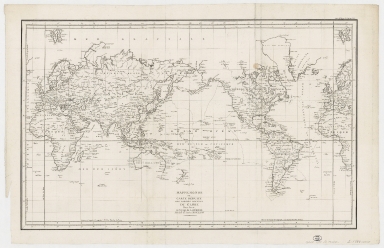
Title
Mappemonde ou Carte réduite des parties connues du globe pour servir au voyage de La Pérouse, fait dans les années 1785, 86, 87, et 88.
Contributor
[La Pérouse, Jean-François de Galaup, comte de, 1741-1788, cartographer, Imprimerie de la République (France), 1795-1804, printer]
Type
Printed
Barcode
4687820501102
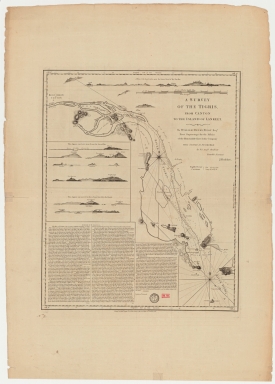
Title
A survey of the Tigris from Canton to the island of Lankeet
Contributor
Huddart, Joseph, 1741-1816
Type
Printed
Barcode
687800354127B
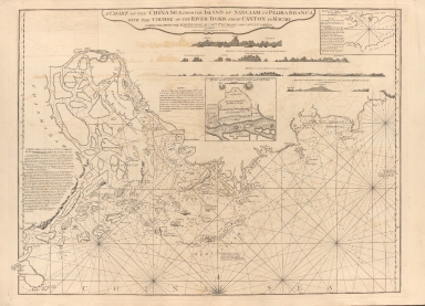
Title
A chart of the China Sea from the Island of Sanciam to Pedra Branca with the course of the River Tigris from Canton to Macao
Contributor
[Après de Mannevillette, Jean-Baptiste-Nicolas-Denis d', 1707-1780, cartographer, Larkins, John Pascal, 17---1794, author, bibliographic antecedent, Anson, George Anson, baron, 1697-1762, author, Huddart, Joseph, 1741-1816, bibliographic antecedent]
Type
Printed
Barcode
3687800354509F
Title
Map of the coasts of China and neighboring islands with some additions
Contributor
Anville, Jean Baptiste Bourguignon d', 1697-1782, cartographer
Type
Printed
Barcode
4687820501175
Title
A chart of the China Sea : inscribed to Mons.r d'Aprés de Mannevillette the ingenious author of the Neptune Oriental, as a tribute due to his labours for the benefit of navigation, and in acknowledgment of his many signal favours to A. Dalrymple.
Contributor
[Dalrymple, Alexander, 1737-1808, hydrographer, Henry, B., fl. 1770-1775, engraver, Whitchurch, William, fl. 18th century, engraver, Lane, Bartholomew, fl. 19th century, engraver, Après de Mannevillette, Jean-Baptiste-Nicolas-Denis d', 1707-1780, dedicatee]
Type
Printed
Barcode
36878003222312
Title
To the Society of Managing Owners of the Ships in the English East India Company's Service, This Chart of the China Sea, Including the Philippina Molluca and Banda Islands, Shewing al the same time all the Tracks into the Pacific Ocean, commonly known by the name of the Eastern Passage to China
Contributor
[Robertson, George, 1748-1788, cartographer, Harmer, Thomas, fl. 1784-1814, engraver]
Type
Printed
Barcode
3687800317471C
Title
A new and correct chart of the coast of China : from latitude 12° north to 26° including Formosa, Hayman and the Philippine Islands.
Contributor
W. and J. Mount, T. and T. Page, 1747-1763, publisher, bookseller
Type
Printed
Barcode
3687800301756B
Title
A new chart of the oriental seas and islands with the coasts of the continent from the Isle of Ceylon to Amoye in China
Contributor
[Après de Mannevillette, Jean-Baptiste-Nicolas-Denis d', 1707-1780, cartographer, Laurie & Whittle, publisher]
Type
Printed
Barcode
3687800354652E
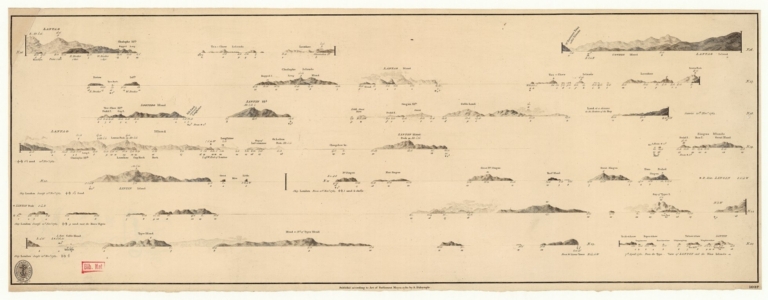
Title
Views of the coasts of China
Contributor
[Great Britain. Hydrographic Office, author, Dalrymple, Alexander, 1737-1808, publisher]
Type
Printed
|