|
REFINE
Browse All : Nautical charts of China and Taiwan
1-5 of 5
Barcode
4687820500450
Title
To John Reeves Esq.re F.R.S. for the liberal aid of his Chinese m.s.s. and the benefit derived from his excellent map of that Empire presented by him to the Hon.ble East India Company this Chart of the East Coast of China
Contributor
[Horsburgh, James, 1762-1836, author, publisher, J. & C. Walker (Firm), engraver, Ross, Daniel, 1780-1849, cartographer, Hall, Basil, 1788-1844, cartographer, Crawford, James H., fl. 18--, cartographer, Rancliffe, George Augustus Henry Anne Parkyns, Baron, 1785-1850, cartographer, Rees, Thomas, 1790-1870, cartographer, Dayot, Félix, 1772-1821, cartographer, Sturgis, Josiah, 1773-1850, cartographer, Rees, John, 1752-18--, cartographer, Hoskiaer, Jacob, 1808-1836, cartographer, Dalrymple, Alexander, 1737-1808, bibliographic antecedent, Reeves, John, 1774-1856, dedicatee]
Type
Printed
Barcode
3687800354567J
Title
[Chart of the Sea of Canton to Cambodia and the Philippines]
Type
Manuscripts
Barcode
3687800354564G
Title
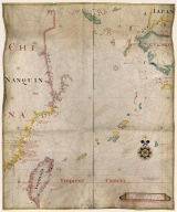
Chart of the China Sea
Contributor
Thornton, John, 1641-1708, cartographer
Type
Manuscripts
Barcode
3687800317471C
Title
A new and correct chart of the coast of China : from latitude 12° north to 26° including Formosa, Hayman and the Philippine Islands.
Contributor
W. and J. Mount, T. and T. Page, 1747-1763, publisher, bookseller
Type
Printed
Barcode
3687800301756B
Title
A new chart of the oriental seas and islands with the coasts of the continent from the Isle of Ceylon to Amoye in China
Contributor
[Après de Mannevillette, Jean-Baptiste-Nicolas-Denis d', 1707-1780, cartographer, Laurie & Whittle, publisher]
Type
Printed
1-5 of 5
|
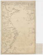
![[Chart of the Sea of Canton to Cambodia and the Philippines]](http://lunamap.must.edu.mo:80/MediaManager/srvr?mediafile=/Size2/MUST~2~2/54/GE+SH+18+PF+181+P+21+RES+Carte+des+mers+de+Canton.jpg)