|
Barcode
3687800354650C
Title
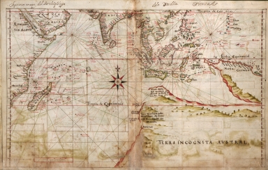
Nautical chart of the Indian Ocean and the Chinese seas
Contributor
Gijsbertsz, Evert, d. 1625, cartographer
Type
Manuscripts
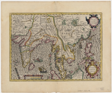
Barcode
4687820500026
Title
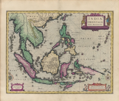
India orientalis
Contributor
[Hondius, Jodocus, 1563-1612, Mercator, Gerhard, 1512-1594]
Type
Printed
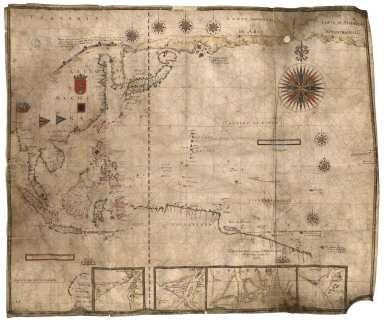
Barcode
4687820500650
Title
明代東西洋航海圖 = The Selden Map
Contributor
Anonymous
Type
Manuscripts
Barcode
4687820500567
Title
Albernaz coast map of Indian Ocean
Contributor
[Albernaz, João Teixeira, active 1602-1648, Attayde, Jeronimo de]
Type
Manuscripts
Barcode
4687820500222
Title
Indiae orientalis nova descriptio
Contributor
Jansson, Jan, 1588-1664
Type
Printed
Barcode
4687820500011
Title
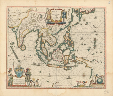
Blaeu map of Southeast Asia and the surrounding areas
Contributor
Blaeu, Willem Janszoon, 1571-1638
Type
Printed
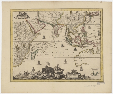
Barcode
4687820500534
Title
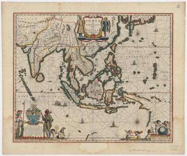
Blaeu map of Southeast Asia and the surrounding areas
Contributor
Blaeu, Willem Janszoon, 1571-1638
Type
Printed
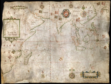
Barcode
4687820501007
Title
[[Carte portugaise de la mer des Indes entre le Cap de Bonne Espérance et le Cap Comorin] ; [Carte portugaise de la mer qui comprend le Golfe du bengale, les côtes de la Chine et les îles du Japon, Philippines, de la Sonde et Moluques], [Carte portugaise de la mer qui comprend le Golfe du bengale, les côtes de la Chine et les îles du Japon, Philippines, de la Sonde et Moluques]]
Contributor
Albernaz, João Teixeira, fl. 1602-1649, cartographer
Type
Printed
Barcode
4687820501029
Title
[[Carte portugaise de la mer des Indes entre le Cap de Bonne Espérance et le Cap Comorin] ; [Carte portugaise de la mer qui comprend le Golfe du bengale, les côtes de la Chine et les îles du Japon, Philippines, de la Sonde et Moluques], [Carte portugaise de la mer des Indes entre le Cap de Bonne Espérance et le Cap Comorin]]
Contributor
Albernaz, João Teixeira, fl. 1602-1649, cartographer
Type
Printed
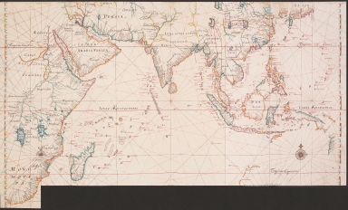
Barcode
4687820500080
Title
Map of the Indian Ocean
Contributor
Jansson, Jan, 1588-1664
Type
Printed
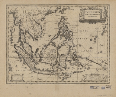
Barcode
4687820500371
Title
Insularum Indiae Orientalis : nova descriptio
Contributor
Jansson, Jan, 1588-1664
Type
Printed
Barcode
4687820500318
Title
Tabula Indiae orientalis
Contributor
Wit, Frederik de
Type
Printed
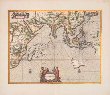
Barcode
4687820500094
Title
Map of the Indian Ocean
Contributor
Vinckeboons, Joan
Type
Printed
Barcode
3687800354561D
Title
Map of the Chinese Sea and Coast, from Drioens Strait to Nanquin, and the Islands from Borneo to Japan and Ladrones
Contributor
Blaeu, Joan, 1650-1712, cartographer
Type
Manuscripts
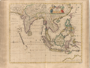
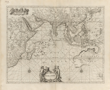
Barcode
4687820500489
Title
Mar di India
Contributor
Anonymous
Type
Printed
Barcode
4687820500027
Title
Nova tabula Indiae Orientalis
Contributor
Allard, Carel, 1648-approximately 1709
Type
Printed
Barcode
4687820500237
Title
Asia : diuisa nelle sue parti secondo lo stato presente.Part 2
Contributor
Coronelli, Vincenzo, 1650-1718
Type
Printed
Barcode
4687820500800
Title
[Map of the East Indies]
Contributor
Anonymous
Type
Printed
Barcode
3687800354308C
Title
Gulf of Tonkin to Luzon and Formosa
Contributor
Thornton, John, 1641-1708, hydrographer
Type
Manuscripts
Barcode
3687800317476H
Title
Gulf of Tonkin to Luzon and Formosa
Contributor
Thornton, John, 1641-1708, cartographer
Type
Manuscripts
Barcode
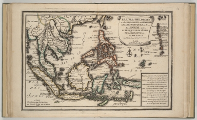
4687820500488
Title
Les Isles Philippines et celles des Larrons ou de Marianes, les Isles Moluques et de la Sonde, avec, la presqu'isle de l'Inde de là le Gange ou Orientale
Contributor
Fer, Nicolas de, 1646-1720
Type
Printed
Barcode
4687820501075
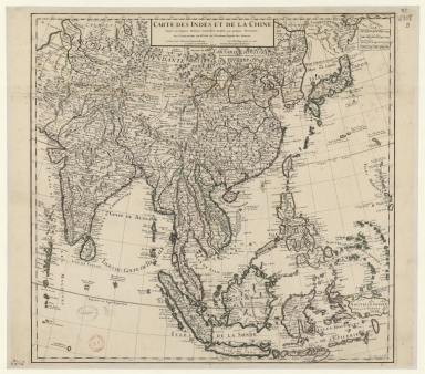
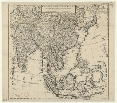
Title
Carte des Indes et de la Chine : dressée sur plusieurs relations particulières rectifiées par quelques observations
Contributor
[Delisle, Guillaume, 1675-1726, cartographer, publisher, Renard, Louis, ca. 1678-1746, publisher]
Type
Manuscripts
Barcode
3687800354316B
Title
Carte des Indes et de la Chine : dressée sur plusieurs relations particulières rectifiées par quelques observations
Contributor
[Delisle, Guillaume, 1675-1726, publisher, Renard, Louis, ca. 1678-1746, publisher]
Type
Printed
Barcode
4687820501190
Title
[Carte des Mers de Java jusqu'à Canton]
Contributor
Robert
Type
Manuscripts
Barcode
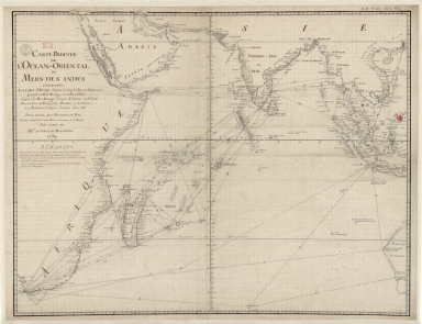
36878003222413
Title
Carte reduite de l'Ocean-Oriental ou Mers des Indes : contenant les costes d Afrique dépuis le cap de Bonne-Espérance, jusqu'a la Mer Rouge, et celles d'Asie dépuis la Mer Rouge, jusqu'a Canton en Chine : Avec les Isles de Madagascar, Bourbon, et de France, les Maldives, I. Ceylan, Sumatra, Java, &.a Pour servir aux vaisseaux du Roy
Contributor
[Le Moyne, François-Pierre, 1713-1795, cartographer, Maurepas, Jean-Frédéric Phélypeaux, comte de, 1701-1781, patron]
Type
Manuscripts
Barcode
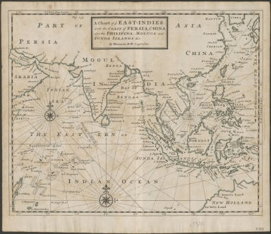
4687820500788
Title
A chart of ye East-Indies with the coast of Persia, China also the Philipina, Moluca and Sunda Islands, &c.
Contributor
Moll, Herman, -1732
Type
Printed
Barcode
4687820500782
Title
A chart of the East India Islands with the coasts of the continent from Caliminera Point to Amoye in China
Contributor
Anonymous
Type
Printed
Barcode
4687820500348
Title
Mapa que demuestra el derrotero q[ue] : hizo M. Cook en 1776, 1777, 1778, y 1779 en su tercero y ultimo viaje
Contributor
Anonymous
Type
Printed
Barcode
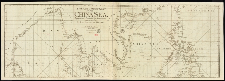
4687820501178
Title
A new and correct chart of the China Sea
Contributor
[Moore, John Hamilton, 1738-1807, cartographer, Blake, T. J., fl. 1785-1785, engraver]
Type
Printed
Barcode
4687820501172
Title
[Route de M. de Richery en 1787 de Pondichery a Canton]
Type
Manuscripts
Barcode
36878003222312
Title
To the Society of Managing Owners of the Ships in the English East India Company's Service, This Chart of the China Sea, Including the Philippina Molluca and Banda Islands, Shewing al the same time all the Tracks into the Pacific Ocean, commonly known by the name of the Eastern Passage to China
Contributor
[Robertson, George, 1748-1788, cartographer, Harmer, Thomas, fl. 1784-1814, engraver]
Type
Printed
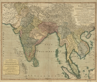
Barcode
4687820500526
Title
A new general map of the East Indies : exhibiting in the Peninsula on this side of the Ganges, or Hindoostan, the several partitions of the Mogul's Empire ; and the dominions of the English East India Company in the provinces of Bengal, Bahar, Orixa, as well as upon the coasts of Malabar and Coromandel ; with the French and Dutch possessions according to the peace of 1783 : and in the peninsula beyond the Ganges, the kingdoms of Assam, Cashar, Aua, Aracan, Mien, Pegu, Siam, Lao and Cambodia, &c.
Contributor
[Jefferys, Thomas, -1771, Rennell, James, 1742-1830]
Type
Printed
Barcode
4687820500260
Title
A chart of the China Sea, and Philippine Islands with the Archipelagos of Felicia and Soloo : shewing the whole tract comprized, between Canton and Balambangan, with the soundings, shoals, rocks, & ca.
Contributor
Whittle & Laurie, publisher
Type
Printed
Barcode
3687800301756B
Title
A new chart of the oriental seas and islands with the coasts of the continent from the Isle of Ceylon to Amoye in China
Contributor
[Après de Mannevillette, Jean-Baptiste-Nicolas-Denis d', 1707-1780, cartographer, Laurie & Whittle, publisher]
Type
Printed
Barcode
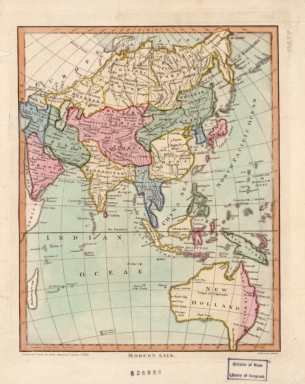
4687820500588
Title
Modern Asia
Contributor
[Wilkes, John, of Milland House, Sussex, Neele, Samuel John, 1758-1824]
Type
Printed
Barcode
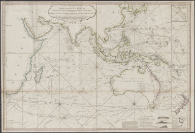
4687820500791
Title
Laurie and Whittle's New chart of the Indian and Pacific Oceans between the Cape of Good Hope, New Holland and Japan : comprehending New Zealand, New Caledonia, New Britain, New Ireland, New Guinea &c., Louisiade and New Georgia; also The Pelew, New Caroline, Ladrone and Philippine Islands &c. with the most remarkable tracks of the English, Spanish, French and Dutch navigators and chiefly the track of the Walpole, EastIndiaman, Captn. Thos. Butler, 1794 from the Cape of Good Hope to Van Diemen's Land and from thence to China, and the track of the Royal Admiral Captn. Henr. Bond in 1792 and 93 from the Cape to Port Jackson and China
Contributor
Laurie & Whittle
Type
Printed
Barcode
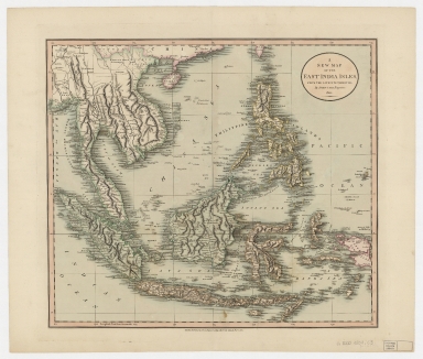
4687820500396
Title
A new map of the East India Isles from the latest authorities
Contributor
Cary, John, approximately 1754-1835
Type
Printed
Barcode
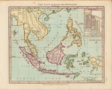
4687820500127
Title
The east Indian archipelago
Contributor
Luffman, J. (John), 1756-1846
Type
Printed
Barcode
4687820500447
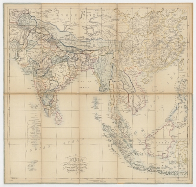
Title
India and countries adjacent : to accompany Symond's Introduction to the geography of India
Contributor
[Mahon, G. W. (George William), Sinclair, J.]
Type
Printed
Barcode
4687820500394
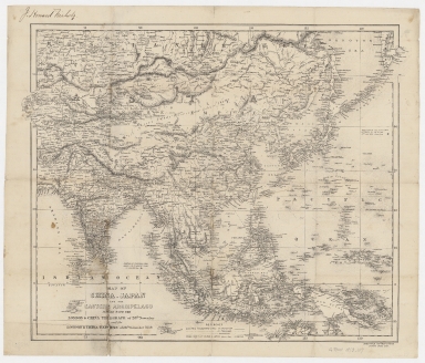
Title
Map of China, Japan and the eastern archipelago : issued with the London & China Telegraph of 28th November and the London & China Express of 26th November 1859
Contributor
Wyld, James, 1812-1887
Type
Printed
Barcode
4687820500458
Title
Asie orientale : comprenant l'Empire Chinois et le Japon, les états de l'Indo-Chine et le grand archipel d'Asie
Contributor
Andriveau-Goujon, E. (Eugène), 1832-1897
Type
Printed
Barcode
4687820500365
Title
New map of China, Corea, Anam and Siam, with portions of Burmah and Malaysia
Contributor
Rand McNally and Company
Type
Printed
Barcode
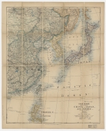
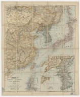
3687800354468J
Title
Stanford's map of eastern China, Japan and Korea : the seat of war in 1894
Contributor
Edward Stanford Ltd., author, publisher
Type
Printed
Barcode
3687800354469K
Title
Stanford's map of Eastern China, Japan and Korea : 1898.
Contributor
Edward Stanford Ltd., author, publisher
Type
Printed
Barcode
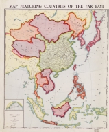
4687820500542
Title
Map featuring countries of the far east
Contributor
Geographical Publishing Co.
Type
Printed
Barcode
4687820500605
Title
Map featuring countries of the far east
Contributor
Geographical Publishing Co.
Type
Printed
Barcode
4687820500479
Title
The Design of the Third Part of Asia
Contributor
[Gastaldi, Giacomo, ca. 1500-ca. 1565, cartographer, Licinius, Fabius, 1521-1565, engraver, Libraria di San Marco (Venice), bookseller, Fugger, Marcus, 1529-1597, dedicatee, Hauslab, Franz, Ritter von, 1798-1883, former owner, Liechtenstein, House of, former owner]
Type
Printed
Barcode
3687800354088H
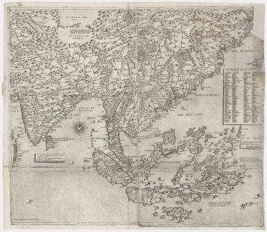
Title
[Southeast China, Japan, East Indies (northern part)]
Contributor
[Dourado, Fernão Vaz, 1520-1580, cartographer, Huth, Henry, 1815–1878, former owner]
Type
Manuscripts
Barcode
3687800354095F
Title
Tabula geograph. in qua Europae, Africae, Asiaeq[ue] et circujacentium insularum orae maritimae accuratè describuntur et ad intelligentia navigationum Indicaru[m] accommodantu
Contributor
[Pontanus, Johannes Isacius, 1571-1639, cartographer, Hondius, Jodocus, 1563-1612, engraver, printer]
Type
Printed
|
![[[Carte portugaise de la mer des Indes entre le Cap de Bonne Espérance et le Cap Comorin] ; [Carte portugaise de la mer qui comprend le Golfe du bengale, les côtes de la Chine et les îles du Japon, Philippines, de la Sonde et Moluques], [Carte portugaise de la mer qui comprend le Golfe du bengale, les côtes de la Chine et les îles du Japon, Philippines, de la Sonde et Moluques]]](http://lunamap.must.edu.mo:80/MediaManager/srvr?mediafile=/Size2/MUST~2~2/54/GE+DD-2987+Carte+portugaise+de+la+mer+des+Indes+-2+.jpg)
![[[Carte portugaise de la mer des Indes entre le Cap de Bonne Espérance et le Cap Comorin] ; [Carte portugaise de la mer qui comprend le Golfe du bengale, les côtes de la Chine et les îles du Japon, Philippines, de la Sonde et Moluques], [Carte portugaise de la mer des Indes entre le Cap de Bonne Espérance et le Cap Comorin]]](http://lunamap.must.edu.mo:80/MediaManager/srvr?mediafile=/Size1/MUST~2~2/54/GE+DD-2987+Carte+portugaise+de+la+mer+des+Indes+-1+.jpg)

![[Map of the East Indies]](http://lunamap.must.edu.mo:80/MediaManager/srvr?mediafile=/Size2/MUST~2~2/41/RBRS+N+910.91+T418-69.jpg)

![[Carte des Mers de Java jusqu'à Canton]](http://lunamap.must.edu.mo:80/MediaManager/srvr?mediafile=/Size1/MUST~2~2/54/GE+SH+18+PF+181+P+19+RES+Carte+des+Mers+de+Java.jpg)

![Mapa que demuestra el derrotero q[ue] : hizo M. Cook en 1776, 1777, 1778, y 1779 en su tercero y ultimo viaje](http://lunamap.must.edu.mo:80/MediaManager/srvr?mediafile=/Size1/MUST~2~2/22/G9231_S12_1780_L5.jpg)
![[Route de M. de Richery en 1787 de Pondichery a Canton]](http://lunamap.must.edu.mo:80/MediaManager/srvr?mediafile=/Size2/MUST~2~2/54/GE+SH+18+PF+182+P+6+D_Routes+de+M+de+Richery+en+1787.jpg)


![[Southeast China, Japan, East Indies (northern part)]](http://lunamap.must.edu.mo:80/MediaManager/srvr?mediafile=/Size2/MUST~2~2/45/000434.jpg)
![Tabula geograph. in qua Europae, Africae, Asiaeq[ue] et circujacentium insularum orae maritimae accuratè describuntur et ad intelligentia navigationum Indicaru[m] accommodantu](http://lunamap.must.edu.mo:80/MediaManager/srvr?mediafile=/Size2/MUST~2~2/35/MAP+RM+3289.jpg)