|
Barcode
4687820501102
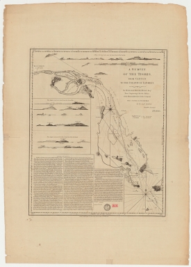
Title
A survey of the Tigris from Canton to the island of Lankeet
Contributor
Huddart, Joseph, 1741-1816
Type
Printed
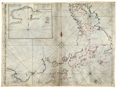
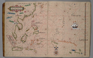
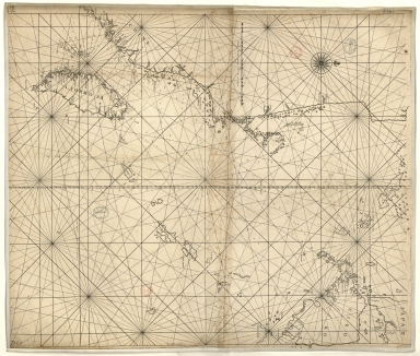
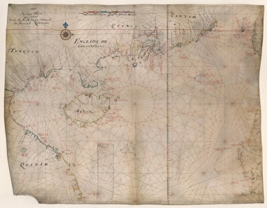
Barcode
4687820500576
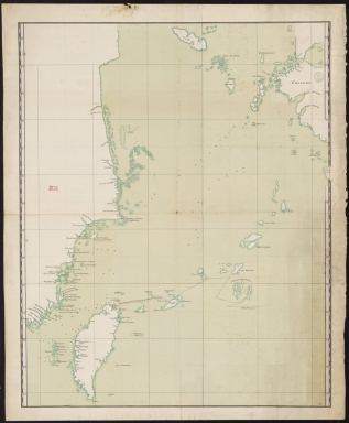
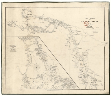
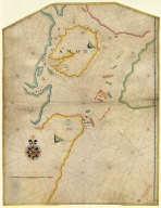
Title
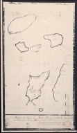
[Tonquin, Quancy, Aynam]
Contributor
[Hacke, William, fl. 16--, cartographer, Sharpe, Bartholomew, fl. 1679-1682, author]
Type
Manuscripts
Barcode
4687820500020
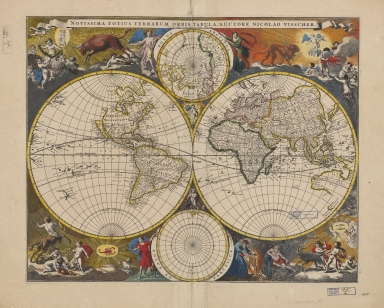
Title
Novissima totius terrarum orbis tabula
Contributor
Visscher, Nicolaes, 1649-1702, author, printer
Type
Printed
Barcode
36878003542339
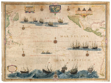
Title
Mar del Sur. Mar Pacifico
Contributor
Gerritsz, Hessel, ca. 1581-1632, cartographer
Type
Manuscripts
Barcode
4687820500524
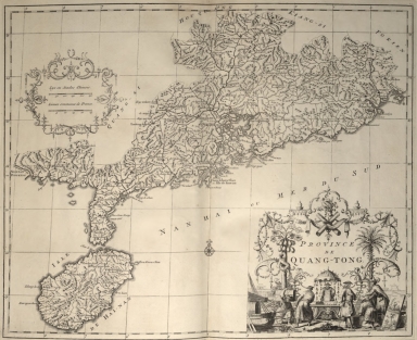
Title
Province de Quang-Tong
Contributor
Anville, Jean Baptiste Bourguignon d', 1697-1782, cartographer
Type
Printed
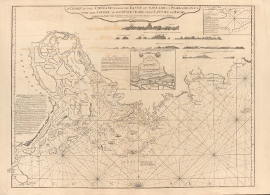
Barcode
687800354127B
Title
A chart of the China Sea from the Island of Sanciam to Pedra Branca with the course of the River Tigris from Canton to Macao
Contributor
[Après de Mannevillette, Jean-Baptiste-Nicolas-Denis d', 1707-1780, cartographer, Larkins, John Pascal, 17---1794, author, bibliographic antecedent, Anson, George Anson, baron, 1697-1762, author, Huddart, Joseph, 1741-1816, bibliographic antecedent]
Type
Printed
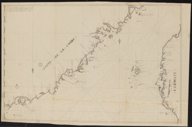
Barcode
3687800354261A
Title
Carte de côte de la Chine depuis les 22.e jusqu'au 25.e 30.m de latitude nord comprenant la partie de Ouest de l'Isle Formose
Type
Manuscripts
Barcode
4687820500952
Title
Kouang-tcheou-fou.
Contributor
Klaproth, Julius von, 1783-1835, cartographer
Type
Manuscripts
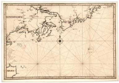
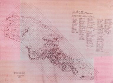
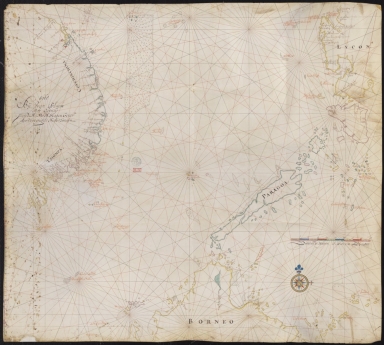
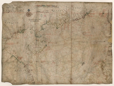
Barcode
3687800354567J
Title
[Chart of the Sea of Canton to Cambodia and the Philippines]
Type
Manuscripts
Barcode
3687800354509F
Title
Map of the coasts of China and neighboring islands with some additions
Contributor
Anville, Jean Baptiste Bourguignon d', 1697-1782, cartographer
Type
Printed
Barcode
3687800354508E
Title
Map of the coasts of China and neighboring islands with some additions
Contributor
Anville, Jean Baptiste Bourguignon d', 1697-1782, cartographer
Type
Manuscripts
Barcode
3687800317478J
Title
Dutch nautical chart of the 18th century, including the coasts of Annam, Tonkin, China, Hainan Island and part of Luzon
Contributor
Saffroy, Amand, 1844-1905, former owner
Type
Manuscripts
Barcode
3687800354255D
Title
Map of the South China Sea
Contributor
Blaeu, Joan, 1596-1673, cartographer
Type
Manuscripts
Barcode
3687800354308C
Title
Gulf of Tonkin to Luzon and Formosa
Contributor
Thornton, John, 1641-1708, hydrographer
Type
Manuscripts
Barcode
3687800354564G
Title
Chart of the China Sea
Contributor
Thornton, John, 1641-1708, cartographer
Type
Manuscripts
Barcode
3687800317483F
Title
Dutch Chart of the China Sea
Type
Manuscripts
Barcode
3687800354561D
Title
Map of the Chinese Sea and Coast, from Drioens Strait to Nanquin, and the Islands from Borneo to Japan and Ladrones
Contributor
Blaeu, Joan, 1650-1712, cartographer
Type
Manuscripts
Barcode
3687800354228D
Title
Gulf of Tonkin
Contributor
Blaeu, Joan, 1596-1673, cartographer
Type
Manuscripts
Barcode
3687800354566I
Title
Gulf of Tonkin
Contributor
Blaeu, Joan, 1650-1712, cartographer
Type
Manuscripts
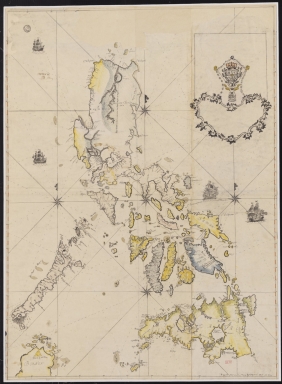
Barcode
4687820501106
Title
Filipinas
Contributor
Bagay, Nicolás de la Cruz, 1701-1771, cartographer
Type
Manuscripts
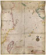
Barcode
3687800354499N
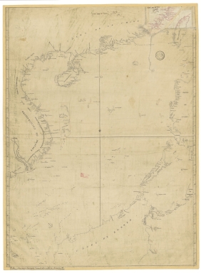
Title
[Map of the southeast coast of China]
Type
Manuscripts
Barcode
3687800354560C
Title
China Sea
Contributor
Blaeu, Joan, 1596-1673, cartographer
Type
Manuscripts
Barcode
3687800354571E
Title
Island of Amoy
Contributor
Thornton, John, 1641-1708, cartographer
Type
Manuscripts
Barcode
3687800354570D
Title
English chart of the island of Amoy
Contributor
Thornton, John, 1641-1708, cartographer
Type
Manuscripts
Barcode
3687800354262B
Title
Southern part of the China Se
Type
Manuscripts
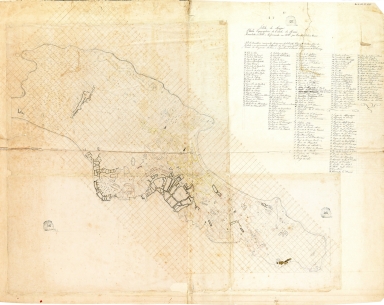
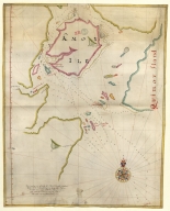
Barcode
3687800354259H
Title
Chart of the seas of Canton to Cambodia and the Philippines
Type
Manuscripts
Barcode
4687820501175
Title
A chart of the China Sea : inscribed to Mons.r d'Aprés de Mannevillette the ingenious author of the Neptune Oriental, as a tribute due to his labours for the benefit of navigation, and in acknowledgment of his many signal favours to A. Dalrymple.
Contributor
[Dalrymple, Alexander, 1737-1808, hydrographer, Henry, B., fl. 1770-1775, engraver, Whitchurch, William, fl. 18th century, engraver, Lane, Bartholomew, fl. 19th century, engraver, Après de Mannevillette, Jean-Baptiste-Nicolas-Denis d', 1707-1780, dedicatee]
Type
Printed
Barcode
36878003712158
Title
Mappa da barra de Macáo
Contributor
Rendo, Custódio de Azevedo, cartographer
Type
Printed
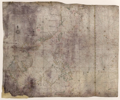
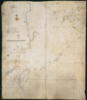
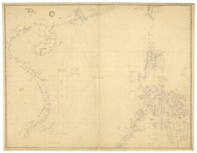
Barcode
3687800371235A
Title
[Carte de la ville et de la rade de Macao]
Type
Manuscripts
Barcode
36878003222312
Title
To the Society of Managing Owners of the Ships in the English East India Company's Service, This Chart of the China Sea, Including the Philippina Molluca and Banda Islands, Shewing al the same time all the Tracks into the Pacific Ocean, commonly known by the name of the Eastern Passage to China
Contributor
[Robertson, George, 1748-1788, cartographer, Harmer, Thomas, fl. 1784-1814, engraver]
Type
Printed
Barcode
3687800317471C
Title
A new and correct chart of the coast of China : from latitude 12° north to 26° including Formosa, Hayman and the Philippine Islands.
Contributor
W. and J. Mount, T. and T. Page, 1747-1763, publisher, bookseller
Type
Printed
Barcode
3687800317467H
Title
Chart of the China Sea
Type
Manuscripts
Barcode
3687800354234A
Title
Consult the numbers in the city of Macau
Contributor
Vinckeboons, Joan, 1617-1670, cartographer
Type
Printed
Barcode
36878003222323
Title
Chart of the river of Canton : taking Its origin, from the Tartar mountains, and passing through various Chinese provinces, until at last it discharges its water, into the great sea at Macau
Contributor
Vinckeboons, Joan, 1617-1670, cartographer
Type
Manuscripts
Barcode
36878002400386
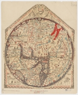
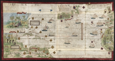
Title
Hereford Mappa Mundi
Contributor
Ricardus, de Bello, fl. 1276-1312, cartographer
Type
Printed
Barcode
3687800354297J
Title
North Atlantic Ocean
Contributor
[Homem, Lopo, fl. 1517-1565, cartographer, Reinel, Pedro, ca. 1464-ca. 1542, cartographer, Reinel, Jorge, ca. 1502-ca. 1572, cartographer, António de Holanda, 1480?-1556, illustrator, Miller, Emmanuel, 1812-1886, former owner, Santarém, Manuel Francisco de Barros e Sousa de Mesquita de Macedo Leitão e Carvalhosa, 1791-1856, 2nd viscount of, former owner]
Type
Manuscripts
Barcode
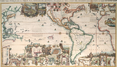
3687800354077F
Title
Carte tres curieuse de la mer du sud : contenant des remarques nouvelles et tres utiles non seulement sur les ports et iles de cette mer, mais aussy sur les principaux pays de l'Amerique tant Septentrionale que Meridionale, avec les noms & la route des voyageurs par qui la decouverte en a été faite. Le tout pour l'intelligence des disseratations suivantes.
Contributor
Chatelain, Henri Abraham, 1684-1743, cartographer
Type
Printed
Barcode
3687800285630D
Title
Ebstorf mappamundi
Contributor
[Gervase, of Tilbury, ca. 1160-ca. 1211, cartographer, Miller, Konrad, 1844-1933, editor, Eckstein & Stähle, publisher]
Type
Printed
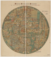
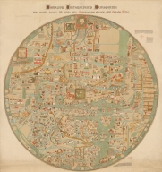
Barcode
3687800354588M
Title
Ebstorf Map
Contributor
[Gervase, of Tilbury, ca. 1160-ca. 1211, cartographer, Miller, Konrad, 1844-1933, editor, Eckstein & Stähle, publisher]
Type
Printed
Barcode
3687800354590F
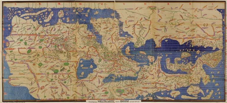
Title
Charta Rogeriana
Contributor
[Idrīsī, ca. 1100-1166, cartographer, Miller, Konrad, 1844-1933, editor, publisher]
Type
Manuscripts
Barcode
3687800285605F
Contributor
[Braun, Georg, 1541-1622, author, Kempen, Gottfried von, fl. 1576-1598, printer, Hogenberg, Frans, ca. 1539-1590, bookseller]
Type
Printed
Barcode
36878003222413
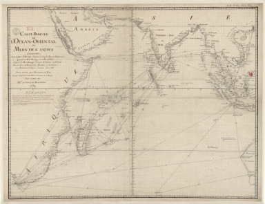
Title
Carte reduite de l'Ocean-Oriental ou Mers des Indes : contenant les costes d Afrique dépuis le cap de Bonne-Espérance, jusqu'a la Mer Rouge, et celles d'Asie dépuis la Mer Rouge, jusqu'a Canton en Chine : Avec les Isles de Madagascar, Bourbon, et de France, les Maldives, I. Ceylan, Sumatra, Java, &.a Pour servir aux vaisseaux du Roy
Contributor
[Le Moyne, François-Pierre, 1713-1795, cartographer, Maurepas, Jean-Frédéric Phélypeaux, comte de, 1701-1781, patron]
Type
Manuscripts
Barcode
36878003541237
Title
Plan de la Riviere de Canton en Chine
Type
Manuscripts
Barcode
3687800317484G
Title
Handwritten map of the coasts of the province of Canton
Contributor
Jaillot, Alexis Hubert, ca. 1632-1712, cartographer
Type
Manuscripts
Barcode
3687800301756B
Title
A new chart of the oriental seas and islands with the coasts of the continent from the Isle of Ceylon to Amoye in China
Contributor
[Après de Mannevillette, Jean-Baptiste-Nicolas-Denis d', 1707-1780, cartographer, Laurie & Whittle, publisher]
Type
Printed
Barcode
3687800354598N
Title
Planta topográfica da cidade de Macau
Contributor
[Osório, Cândido António, 1803-1874, cartographer, Marques Pereira, João Feliciano, 1863-1909, former owner]
Type
Manuscript
Barcode
36878003546018
Title
Planta topográfica da cidade de Macau
Contributor
[Osório, Cândido António, 1803-1874, cartographer, Guimarães, João, creator]
Type
Printed
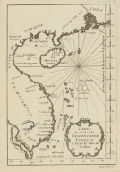
Barcode
3687800354488L
Title
Carte des costes de Cochinchine Tunquin et partie de celles de la Chine.
Type
Manuscript
|
![[Tonquin, Quancy, Aynam]](http://lunamap.must.edu.mo:80/MediaManager/srvr?mediafile=/Size2/MUST~2~2/33/G2201.P5+H3+1690.jpg)
![[Chart of the Sea of Canton to Cambodia and the Philippines]](http://lunamap.must.edu.mo:80/MediaManager/srvr?mediafile=/Size2/MUST~2~2/54/GE+SH+18+PF+181+P+21+RES+Carte+des+mers+de+Canton.jpg)


![[Map of the southeast coast of China]](http://lunamap.must.edu.mo:80/MediaManager/srvr?mediafile=/Size2/MUST~2~2/54/SH+18+PF+181+P+16+D.jpg)

![[Carte de la ville et de la rade de Macao]](http://lunamap.must.edu.mo:80/MediaManager/srvr?mediafile=/Size1/MUST~2~2/325/3687800371235A%28FRAN_2018_01313%29.jpg)