WHERE
|
Barcode
4687820501175
Title
A chart of the China Sea : inscribed to Mons.r d'Aprés de Mannevillette the ingenious author of the Neptune Oriental, as a tribute due to his labours for the benefit of navigation, and in acknowledgment of his many signal favours to A. Dalrymple.
Contributor
[Dalrymple, Alexander, 1737-1808, hydrographer, Henry, B., fl. 1770-1775, engraver, Whitchurch, William, fl. 18th century, engraver, Lane, Bartholomew, fl. 19th century, engraver, Après de Mannevillette, Jean-Baptiste-Nicolas-Denis d', 1707-1780, dedicatee]
Type
Printed
Barcode
687800354127B
Title
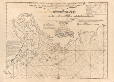
A chart of the China Sea from the Island of Sanciam to Pedra Branca with the course of the River Tigris from Canton to Macao
Contributor
[Après de Mannevillette, Jean-Baptiste-Nicolas-Denis d', 1707-1780, cartographer, Larkins, John Pascal, 17---1794, author, bibliographic antecedent, Anson, George Anson, baron, 1697-1762, author, Huddart, Joseph, 1741-1816, bibliographic antecedent]
Type
Printed
Barcode
4687820500260
Title
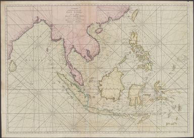
A chart of the China Sea, and Philippine Islands with the Archipelagos of Felicia and Soloo : shewing the whole tract comprized, between Canton and Balambangan, with the soundings, shoals, rocks, & ca.
Contributor
Whittle & Laurie, publisher
Type
Printed
Barcode
4687820500782
Title
A chart of the East India Islands with the coasts of the continent from Caliminera Point to Amoye in China
Contributor
Anonymous
Type
Printed
Barcode
4687820500785
Title
A chart of the eastermost part of the East Indies from the island Zeloan to Amoy in China : with the adjacent islands adjusted according to the most accurate astronomical observations
Contributor
Seller, John, active 1658-1698
Type
Printed
Barcode
4687820500255
Title
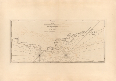
A chart of the south coast of Hay-nan, from Tinhosa to Guichou
Contributor
[Haldane, John, captain, fl. 177-, cartographer, Laurie & Whittle, publisher]
Type
Printed
Barcode
4687820500256
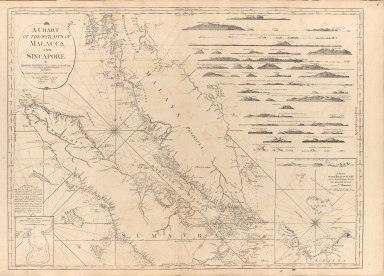
Title
A chart of the Straits of Malacca and Sincapore
Contributor
Thomas, Jeffrey
Type
Printed
Barcode
4687820500788
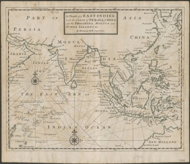
Title
A chart of ye East-Indies with the coast of Persia, China also the Philipina, Moluca and Sunda Islands, &c.
Contributor
Moll, Herman, -1732
Type
Printed
Barcode
3687800301791A
Title
A chart, on Mercator's projection, containing the track and soundings of the Lion, the Hindostan and Tenders, from Turon-Bay in Cochin-China to the mouth of the Pei-Ho River in the Gulph of Pe-Tche-Lee or Pekin
Contributor
[Barrow, John, 1764-1848, cartographer, Baker, Benjamin, fl. 1780-1824, engraver, Nicol, George, ca. 1740-1828, publisher]
Type
Printed
Barcode
4687820500783
Title
A general chart of the China Sea : drawn from the journals of the European navigators, particularly from those collected by Capt. Hayter
Contributor
Anonymous
Type
Printed
Barcode
4687820500262
Title
A general chart, on Mercator's projection, to shew the track of the Lion and Hindostan from England to the Gulph of Pekin in China, and of their return to England
Contributor
Barrow, John
Type
Printed
Barcode
4687820500792
Title
A general chart, on Mercator's projection, to shew the track of the Lion and Hindostan from England to the Gulph of Pekin in China, and of their return to England : with the daily statement of the barometer and thermometer as observed at noon: containing also the limits of the Chinese Empire as extended by the conquests of the present Emperor Tchien-Lung
Contributor
[Barrow, John, Baker, B. (Benjamin), active 1766-1824]
Type
Printed
Barcode
4687820500076
Title
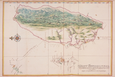
A general map of the island of Formosa / Taiwan
Contributor
Vinckeboons, Joan
Type
Printed
Barcode
4687820500824
Title
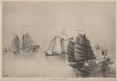
A lorcha in action
Type
Printed
Barcode
4687820500449
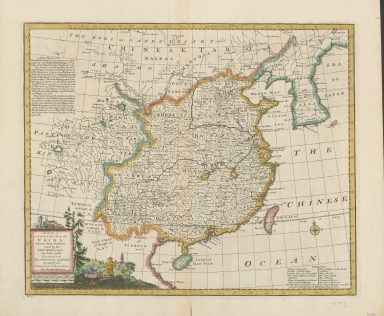
Title
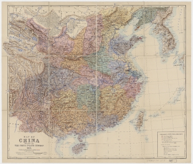
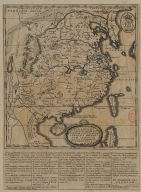
A map of China : prepared for the China Inland Mission, 1905
Contributor
[China Inland Mission, Bretschneider, E., 1833-1901, Edward Stanford Ltd.]
Type
Printed
Barcode
3687800354457H
Title
A Map of the 15 Provinces and 155 Capital Cities of the Chinese Empire
Contributor
[Couplet, Philippe, 1623-1692, cartographer, Louvemont, François de, 1648-ca. 1690, engraver, Nolin, Jean-Baptiste, 1648-1708, printer]
Type
Printed
Barcode
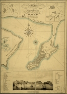
4687820500710
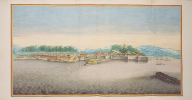
Title
A map of the city and harbour of Macao
Contributor
Bramston, William, 17---18--, author
Type
Printed
Barcode
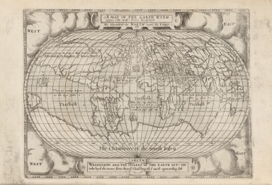
4687820500121
Title
A Map of the earth with names (the most) from scriptures
Contributor
Anonymous
Type
Printed
Barcode
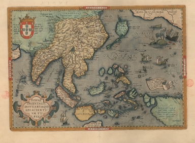
3687800354407C
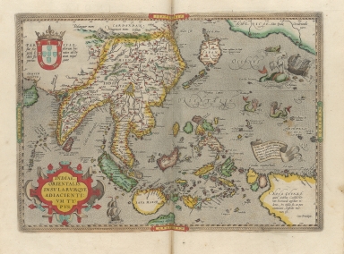
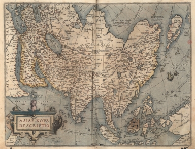
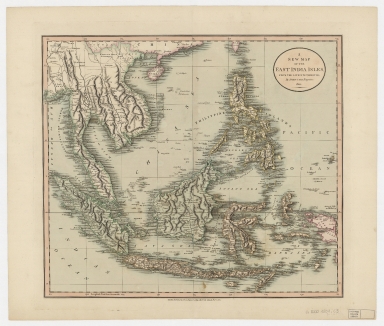
Title
A map of the East Indies and surrounding islands
Contributor
[Ortelius, Abraham, 1527-1598, author, Plantijnsche Drukkerij, printer]
Type
Printed
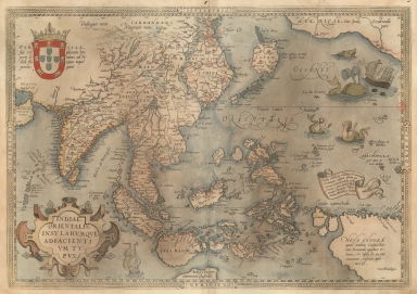
Barcode
3687800301587D
Title
A map of the East Indies and surrounding islands
Contributor
[Ortelius, Abraham, 1527-1598, author, Norton, John, 15---1612, printer]
Type
Printed
Barcode
3687800354449I
Title
A map of the East Indies and surrounding islands.
Contributor
[Ortelius, Abraham, 1527-1598, author, Cónegos Regrantes de Santo Agostinho. Mosteiro de São Vicente de Fora (Lisboa), former owner]
Type
Printed
Barcode
4687820500786
Title
A new & accurate map of China : drawn from surveys made by Jesuit missionaries by order of the Emperor : the whole being regulated by numerous astronomical observations
Contributor
Bowen, Emanuel, -1767
Type
Printed
Barcode
4687820500363
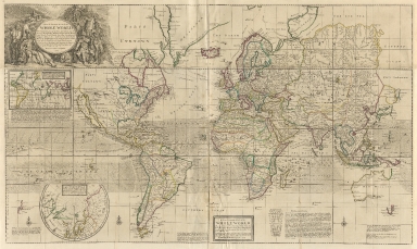
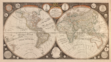
Title
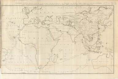
A new & correct map of the whole world
Contributor
Moll, Herman, -1732
Type
Printed
Barcode
4687820500608
Title
A new & correct map of the whole World
Contributor
Moll, Herman, -1732
Type
Printed
Barcode
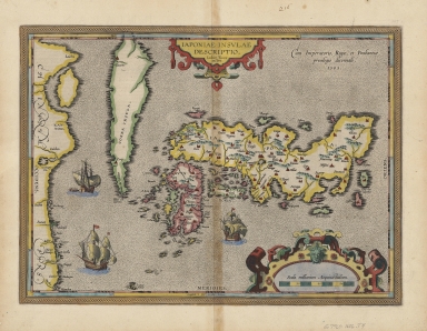
4687820500284
Title
A new and accurate map of the Empire of Japan : laid down from the memoirs of the Portuguese and Dutch, and particularly from the Jesuit missionaries, as publish'd by the Sr. Bellin at Paris, being adjusted by astronomical observat.ns
Contributor
Bowen, Emanuel, ca. 1693-1767, engraver
Type
Printed
Barcode
4687820501178
Title
A new and correct chart of the China Sea
Contributor
[Moore, John Hamilton, 1738-1807, cartographer, Blake, T. J., fl. 1785-1785, engraver]
Type
Printed
Barcode
3687800317471C
Title
A new and correct chart of the coast of China : from latitude 12° north to 26° including Formosa, Hayman and the Philippine Islands.
Contributor
W. and J. Mount, T. and T. Page, 1747-1763, publisher, bookseller
Type
Printed
Barcode
4687820500606
Title
A new and correct map of the world : laid down according to the newest observations & discoveries in several different projections including the trade winds, monsoons, variation of the compass, and illustrated with a coelestial planisphere, the various systems of Ptolomy, Copernicus, and Tycho Brahe together with ye apearances of the planets &c.
Contributor
Godson, W. (William)
Type
Printed
Barcode
3687800354267G
Title
A new chart of the China Sea, with its several entrances : drawn from a great number of draughts, journals, and other National documents, regulated by astronomical observation
Contributor
[Laurie & Whittle, author, publisher, Larkins, John Pascal, 17---1794, cartographer, Rees, Captain, cartographer]
Type
Printed
Barcode
4687820500336
Title
A new chart of the China Sea, with its several entrances : drawn from a great number of draughts, journals, and other National documents, regulated by astronomical observations
Contributor
[Laurie & Whittle, author, publisher, Larkins, John Pascal, 17---1794, cartographer, Rees, Captain, cartographer]
Type
Printed
Barcode
4687820500440
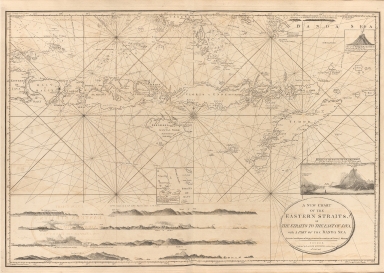
Title
A new chart of the Eastern Straits or the straits to the east of Java with a part of the Banda Sea
Contributor
Williams, Robert
Type
Printed
Barcode
3687800301756B
Title
A new chart of the oriental seas and islands with the coasts of the continent from the Isle of Ceylon to Amoye in China
Contributor
[Après de Mannevillette, Jean-Baptiste-Nicolas-Denis d', 1707-1780, cartographer, Laurie & Whittle, publisher]
Type
Printed
Barcode
3687800354448H
Title
A New Depiction of Asia.
Contributor
[Ortelius, Abraham, 1527-1598, author, Cónegos Regrantes de Santo Agostinho. Mosteiro de São Vicente de Fora (Lisboa), former owner]
Type
Printed
Barcode
4687820500526
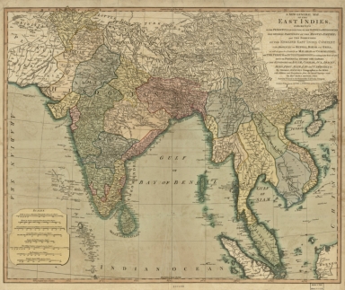
Title
A new general map of the East Indies : exhibiting in the Peninsula on this side of the Ganges, or Hindoostan, the several partitions of the Mogul's Empire ; and the dominions of the English East India Company in the provinces of Bengal, Bahar, Orixa, as well as upon the coasts of Malabar and Coromandel ; with the French and Dutch possessions according to the peace of 1783 : and in the peninsula beyond the Ganges, the kingdoms of Assam, Cashar, Aua, Aracan, Mien, Pegu, Siam, Lao and Cambodia, &c.
Contributor
[Jefferys, Thomas, -1771, Rennell, James, 1742-1830]
Type
Printed
Barcode
4687820500368
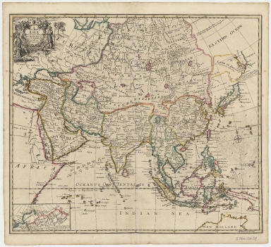
Title
A new map of Asia, from the latest observations : most humbly inscrib'd to the Right Hon.'ble George, Earl of Warrington &c.
Contributor
Senex, John, -1740
Type
Printed
Barcode
4687820500396
Title
A new map of the East India Isles from the latest authorities
Contributor
Cary, John, approximately 1754-1835
Type
Printed
Barcode
4687820500607
Title
A new map of the world : with all the new discoveries by Capt. Cook and other navigators : ornamented with the Solar System, the eclipses of the sun, moon & planets &c.
Contributor
[Kitchen, T. (Thomas), Junior, Evans, John, active 1794-1799]
Type
Printed
Barcode
3687800285782L
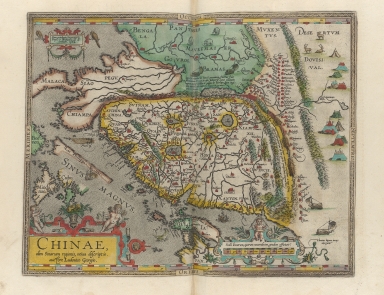
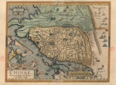
Title
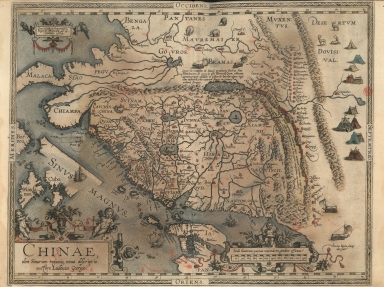
A new representation of China, once called the region of the Chinese, by Ludovicus Georgius
Contributor
[Barbuda, Luís Jorge de, fl. 1575-1584, cartographer, Plantin, Christophe, ca.1520-1589, printer, Norton, John, 15---1612, printer]
Type
Printed
Barcode
3687800354405A
Title
A new representation of China, once called the region of the Chinese, by Ludovicus Georgius.
Contributor
[Barbuda, Luís Jorge de, fl. 1575-1584, cartographer, Plantijnsche Drukkerij, printer]
Type
Printed
Barcode
3687800354447G
Title
A new representation of China, once called the region of the Chinese, by Ludovicus Georgius.
Contributor
[Barbuda, Luís Jorge de, fl. 1575-1584, cartographer, Cónegos Regrantes de Santo Agostinho. Mosteiro de São Vicente de Fora (Lisboa), former owner]
Type
Printed
Barcode
4687820500663
Title
A plan of the city and harbour of Macao : a colony of the Portugueze situated at the southern extremity of the Chinese Empire in Lat. 22 ⁰12ʹ44ʺ N., Long. 113⁰35ʹ0ʺ east of Greenwich
Contributor
Baker, Benjamin, fl. 1766-1824, cartographer
Type
Printed
Barcode
4687820500220
Title
A plan of the city and harbour of Macao : a colony of the Portugueze, situated at the southern extremity of the Chinese Empire in Lat. 22 ⁰12ʹ44ʺ N., long. 113°35ʹ0ʺ east of Greenwich
Contributor
Baker, B. (Benjamin), active 1766-1824
Type
Printed
Barcode
4687820500359
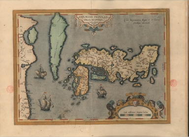
Title
A representation of the island of Japan by Luis Teixeira
Contributor
Teixeira, Luís, 1564-1604, cartographer
Type
Printed
Barcode
3687800354408D
Title
A representation of the island of Japan by Luis Teixeira
Contributor
Teixeira, Luís, 1564-1604, cartographer
Type
Printed
Barcode
4687820501102
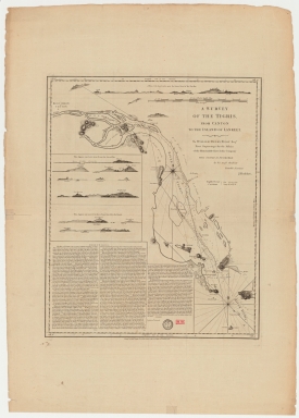
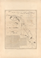
Title
A survey of the Tigris from Canton to the island of Lankeet
Contributor
Huddart, Joseph, 1741-1816
Type
Printed
Barcode
4687820500232
Title
A survey of the Tigris, from Canton to the Island of Lankeet : to William Henry Pigou Esq.r first supercargo for the Affairs of the Honourable East India Company
Contributor
[Huddart, Joseph, 1741-1816, hydragrapher, Pigou, William Henry, dedicatee, Whittle & Laurie, publisher]
Type
Printed
Barcode
6878003015749
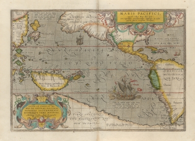
Title
A very new description of the peaceful sea, commonly called South Sea with the regions lying around it, and its islands, scattered everywhere.
Contributor
[Ortelius, Abraham, 1527-1598, author, Plantijnsche Drukkerij, printer, Rockox, Nicolaas, 1560-1640, dedicatee]
Type
Printed
|