WHAT
-
Administrative and polit
…
(48)
-
Aerial views
(11)
-
Aerial Views
(2)
-
Africa -- Maps
(21)
-
Agriculture
(2)
-
Aids to navigation
(1)
-
America -- Maps
(5)
-
Anatolia -- Maps
(1)
-
Arabian Peninsula -- Maps
(6)
-
Armed Forces
(1)
-
Armillary sphere
(1)
-
Asia -- Maps
(7)
-
Astrology
(4)
-
Astronomy
(11)
-
Atlantic Ocean
(1)
-
Atlantic Ocean -- Maps
(13)
-
Atlas
(38)
-
Atmospheric pressure
(3)
-
Black Sea -- Maps
(2)
-
Bonvalot, Gabriel, 1853-1
…
(1)
-
Booklet
(2)
-
Borneo -- Maps
(1)
-
Boundaries
(3)
-
Brahe, Tycho, 1546-1601
(1)
-
Brazil -- Maps
(4)
-
Buddhism
(1)
-
Cables, Submarine
(2)
-
Calendar
(1)
-
Camões, Luís de, 1524?-15
…
(2)
-
Caricature
(7)
-
Caricatures
(6)
-
Cartography
(1)
-
Caspian Sea -- Maps
(1)
-
Celestial globes
(1)
-
Celestial Maps
(3)
-
Central America -- Maps
(7)
-
Certificate
(6)
-
Chart
(4)
-
Charts
(3)
-
Charts, diagrams, etc.
(3)
-
China
(4)
-
China -- Maps
(60)
-
China Inland Mission
(1)
-
China maps
(1)
-
China Sea
(1)
-
China Sea -- Maps
(5)
-
China Submarine Telegraph
…
(1)
-
Christianity
(1)
-
City planning
(6)
-
City Plans & Views
(81)
-
Climate
(1)
-
Climatic zones
(1)
-
Coal mines and mining
(2)
-
Coast defenses
(18)
-
Coastal Map
(1)
-
Coastal map
(1)
-
Coasts
(92)
-
Coat of arms
(1)
-
Coats
(2)
-
Coins, Japanese
(1)
-
Constellations
(8)
-
Contiguous zones (Law of
…
(1)
-
Continental shelf
(1)
-
Cook, James, 1728-1779
(6)
-
Cosmography
(5)
-
Description and Travel
(4)
-
Description and travel
(1)
-
Dieppe Maps
(1)
-
Discoveries in geography
(17)
-
Discovery and exploration
(3)
-
Document
(37)
-
Drake, Francis, approxima
…
(1)
-
Early maps
(35)
-
Early Old Maps
(20)
-
Early works to 1800
(6)
-
Earth
(4)
-
Earth (Planet)
(1)
-
East China Sea
(1)
-
East Indies
(3)
-
East Indies -- Maps
(4)
-
Eastern Africa -- Maps
(1)
-
Ecclesiastical geography
(2)
-
Envelope
(11)
-
Ethnology
(2)
-
Europe -- Maps
(16)
-
Express service
(1)
-
Foreign relations
(2)
-
Fortification
(2)
-
Francis Xavier, Saint, 15
…
(1)
-
Frondat, Nicolas de, 16..
…
(1)
-
Funeral rites and ceremon
…
(1)
-
Genealogy in the Bible
(1)
-
General Maps
(509)
-
Geography
(12)
-
Geography, Ancient
(3)
-
Geography, Medieval
(1)
-
Geology
(1)
-
Guangdong -- Maps
(1)
-
Guide
(1)
-
Harbors
(20)
-
Hemispheres
(41)
-
India -- Maps
(6)
-
Indian Ocean -- Maps
(1)
-
Indian Ocean-- Maps
(1)
-
Industries
(1)
-
International relations
(2)
-
Islands
(4)
-
Itinerary
(21)
-
Japan -- Maps
(1)
-
Land use
(2)
-
Language and languages
(1)
-
Letter
(135)
-
Macao (China) -- Maps
(15)
-
Macao Maps
(1)
-
Macao maps
(1)
-
Magnetic declination
(1)
-
Manuscript
(20)
-
Manuscript maps -- Early
…
(1)
-
Manuscripts
(459)
-
Map
(4)
-
Maps, Manuscript
(2)
-
Markets
(1)
-
Mediterranean -- Maps
(8)
-
Mediterranean Sea
(1)
-
Mediterranean Sea -- Maps
(1)
-
Mexico -- Maps
(1)
-
Military art and science
(22)
-
Military camps
(1)
-
Military engineering
(1)
-
Mines and mineral resourc
…
(1)
-
Missionaries
(1)
-
Missions
(1)
-
Morrison (Ship)
(1)
-
Names, Geographical
(37)
-
Nautical Chart
(22)
-
Nautical chart
(1)
-
Nautical charts
(71)
-
Nautical Charts
(5)
-
Nautical Charts -- Asia
(2)
-
Nautical charts -- South
…
(1)
-
Navigation
(3)
-
Navigational chart
(1)
-
Nederlandsche Oost-Indisc
…
(5)
-
New Guinea -- Maps
(1)
-
North America -- Maps
(7)
-
Notes
(10)
-
Pacific -- Maps
(1)
-
Pacific Coast (Asia) -- M
…
(1)
-
Pacific Ocean
(2)
-
Pacific Ocean -- Maps, Ma
…
(1)
-
Pearl River
(1)
-
Persian Gulf -- Maps
(1)
-
Peru -- Maps
(1)
-
Petroleum
(3)
-
Petroleum refineries
(1)
-
Philippines -- Maps
(3)
-
Photo
(394)
-
Pictorial maps
(1)
-
Pictorial works
(1)
-
Pilot guides
(1)
-
Plan
(3)
-
Planispheres
(6)
-
Plate
(6)
-
Population
(1)
-
Ports
(1)
-
Portugal -- Maps
(1)
-
Power resources
(1)
-
Precipitation (Meteorolog
…
(1)
-
Printed
(781)
-
Profiles
(1)
-
Railroads
(3)
-
Rain and rainfall
(2)
-
Real property
(2)
-
Reclamation of land
(2)
-
Regional planning
(1)
-
Religious
(1)
-
Religious Maps
(1)
-
River surveys
(5)
-
Rivers
(4)
-
Rubbing
(4)
-
Russia -- Maps
(1)
-
Sailing
(1)
-
Sanson, Nicolas, 1600-166
…
(1)
-
Scandinavia -- Maps
(1)
-
Sculpture
(2)
-
Sea Chart
(1)
-
Sea Charts
(402)
-
Seaports
(1)
-
Seasonal winds
(1)
-
Sepulchral monuments
(1)
-
Shipping
(1)
-
South Africa -- Maps
(4)
-
South America -- Maps
(18)
-
Southeast Asia -- Maps
(3)
-
Standards
(1)
-
Straits
(1)
-
Streets
(1)
-
Telegraph
(3)
-
Territorial waters
(1)
-
Theater
(2)
-
Thematic Maps
(105)
-
Theory of Tides
(1)
-
Tides
(4)
-
Timor -- Maps
(1)
-
Title Page
(1)
-
Topographic Maps
(12)
-
Trade winds
(1)
-
Trading posts
(1)
-
Translation
(10)
-
Tratado de Tordesillas (1
…
(1)
-
Travel
(11)
-
Travels
(1)
-
Universe
(1)
-
Vietnam -- Maps
(2)
-
View
(1)
-
Virgin and Child
(1)
-
Voyages and travels
(9)
-
Voyages around the world
(20)
-
Wall map
(1)
-
Waterways
(16)
-
Weights and measures
(1)
-
Western Europe -- Maps
(1)
-
Winds
(1)
-
World -- Maps
(55)
-
World Map
(2)
-
World Maps
(1)
-
World maps, Manuscript
(3)
-
Zheng, He, 1371-1435
(22)
-
人物
(53)
-
全景
(17)
-
動物
(3)
-
城市建設
(272)
-
建築物
(407)
-
校園建設
(63)
-
校園活動
(68)
-
校園生活
(11)
-
植物
(18)
-
澳門城市風貌
(831)
-
澳門文化遺產
(516)
-
澳門科技大學
(141)
-
生活
(34)
-
社會生活與習俗
(1292)
-
節日節慶
(855)
-
自然景象
(24)
-
行業
(346)
-
街區肌里
(86)
-
被評定的不動產(建築文物)
(354)
-
非物質文化遺產
(169)
Less
|
Media item filename
IMG_0445.JPG
Media item filename
IMG_0456.JPG
Media item filename
IMG_0444.JPG
Media item filename
IMG_0451.JPG
Media item filename
IMG_0346.JPG
Media item filename
DJI_0298.jpg
Media item filename
DJI_0284.jpg
Media item filename
G41A1168.JPG
Media item filename
IMG_0449.JPG
Media item filename
G41A1166.JPG
Media item filename
G41A1175.JPG
Media item filename
DJI_0278.jpg
Media item filename
IMG_0453.JPG
Media item filename
G41A1170.JPG
Media item filename
IMG_0447.JPG
Media item filename
IMG_0143.JPG
Media item filename
IMG_0105.JPG
Media item filename
IMG_0141.JPG
Media item filename
G41A1408.JPG
Media item filename
IMG_0570.JPG
Media item filename
G41A0903.JPG
Media item filename
1M7A7094.jpg
Media item filename
1M7A7183.jpg
Media item filename
1M7A7135.jpg
Media item filename
1M7A7093.jpg
Media item filename
1M7A7124.jpg
Media item filename
IMG_0050.JPG
Media item filename
IMG_0065.JPG
Media item filename
IMG_0193.JPG
Media item filename
IMG_0174.JPG
Media item filename
IMG_0221.JPG
Media item filename
IMG_0175.JPG
Media item filename
IMG_0168.JPG
Media item filename
IMG_0159.JPG
Media item filename
IMG_0155.JPG
Media item filename
IMG_0130.JPG
Media item filename
IMG_0478.JPG
Media item filename
IMG_0369.JPG
Media item filename
IMG_0483.JPG
Media item filename
IMG_0480.JPG
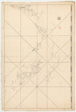
Title
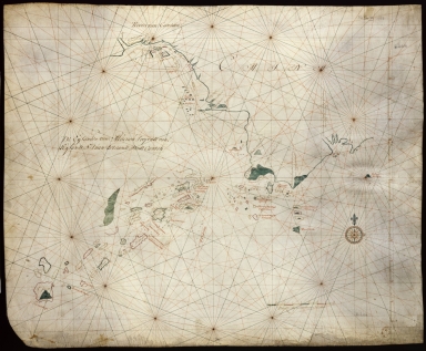
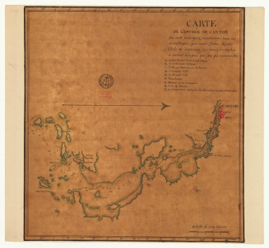
Carte plate d'une partie de la coste de Chine, depuis les isles Pulo-Taya au nord est de l'isle de Haynam, et toutes les isles tant de la la partie de l'ouest que celles de l'e[st] servant de reconnoissance pour l'entrée de la rivière de Canton
Contributor
Dauge, Philippe
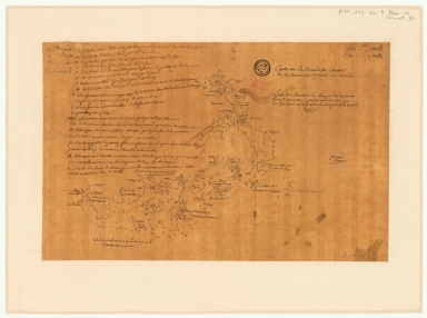
Title
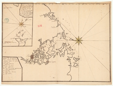
Carte de l'entrée de Canton où sont marquez exactement tous les mouillages, que nous fîmes depuis l'isle de Sanciam, les bancs, les roches et autres dangers que j'ay pu reconnoitre
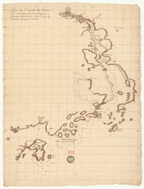
Title
Plan de la rivière de Canton dans la Chinne dans la partie du nord
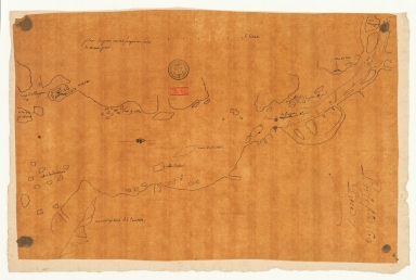
Title
Carte de l'entrée de Canton où sont marquez exactement tous les mouillages, que nous fismes depuis l'isle de Sanciam, les bancs, les roches et autres dangers que j'ay pu reconnoître
Title
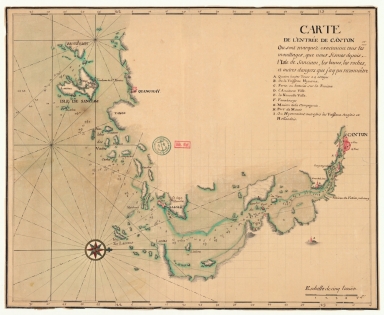
Carte de la rivière de Canton et de ses environs du costé du sud est [corrigé :] ouest
Title
Carte de la rivière de Canton et des îles
Title
Carte de la rivière de Canton et ses environs du costé de l'ouest
Title
Carte de l'entrée de Canton sur la côte de la Chine
Title
De Eӯlanden van Macaoủ, loopende van, t’Eӯlandt S.t Jủan totaande Stadt Canton
Contributor
De Graaf, Isaac, 1667-1743
|

![Carte plate d'une partie de la coste de Chine, depuis les isles Pulo-Taya au nord est de l'isle de Haynam, et toutes les isles tant de la la partie de l'ouest que celles de l'e[st] servant de reconnoissance pour l'entrée de la rivière de Canton](http://lunamap.must.edu.mo:80/MediaManager/srvr?mediafile=/Size2/MUST~2~2/54/GE+SH+18+PF+179+DIV+9+P+9+-+Carte+plate+d%27une+partie+de+la+coste+de+Chine.jpg)
![Carte de la rivière de Canton et de ses environs du costé du sud est [corrigé :] ouest](http://lunamap.must.edu.mo:80/MediaManager/srvr?mediafile=/Size2/MUST~2~2/63/GE+SH+18+PF+179+DIV+9+P+131+D+-+Carte+de+la+rivi%C3%83%C2%A8re+de+Canton+-+sud+est.jpg)