|
REFINE
Browse All : Images by Harmer, Thomas, fl. 1784-1814, engraver
1-3 of 3
Barcode
4687820501171
Title
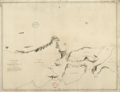
Chart of the Strait of Solor : from a Portuguese ms used by the Portuguese of Macao in the navigation to Timor
Contributor
[Harmer, Thomas, fl. 1784-1814, engraver, Dalrymple, Alexander, 1737-1808, publisher]
Type
Printed
Barcode
3687800354504A
Title
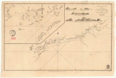
Chart of the south coast of China from Macao to The Brothers
Contributor
[Inverarity, David, 17---18--, cartographer, Dalrymple, Alexander, 1737-1808, editor, publisher, Harmer, Thomas, fl. 1784-1814, engraver]
Type
Printed
Barcode
36878003222312
Title
To the Society of Managing Owners of the Ships in the English East India Company's Service, This Chart of the China Sea, Including the Philippina Molluca and Banda Islands, Shewing al the same time all the Tracks into the Pacific Ocean, commonly known by the name of the Eastern Passage to China
Contributor
[Robertson, George, 1748-1788, cartographer, Harmer, Thomas, fl. 1784-1814, engraver]
Type
Printed
1-3 of 3
|