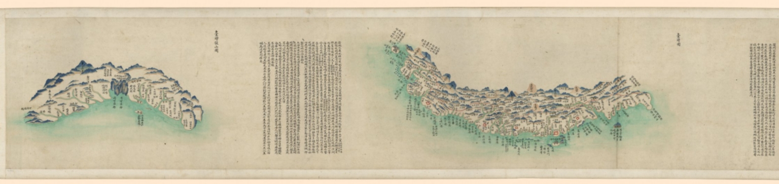
|
Barcode
4687820500132
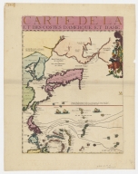
Title
Carte Générale Des Découvertes faites en 1787 dans les Mers De Chine et De Tartarie ou depuis Manille jusqu'à Avatscha : par les Frégates Françaises la Boussole et l'Astrolabe
Contributor
La Pérouse, Jean-François de Galaup, comte de, 1741-1788
Type
Printed
Barcode
4687820501066
Title
Carte hollandaise de la Mer de Chine
Contributor
Anonymous
Type
Manuscripts
Barcode
4687820501087
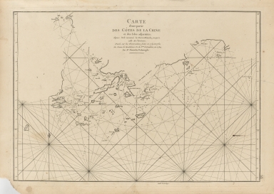
Title
Carte des côtes de Siam et partie de celles de la Chine Depuis le port et l'Ile de Quemoy jusques à la pointe de la presqu'isle de Malaca avec les Isles de Formose, les Philippines, celles de la Sonde avec partie de celles des Moluques
Contributor
Lavigne, 16..-17..
Type
Manuscripts
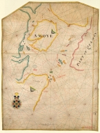
Barcode
4687820501103
Title
Island of Amoy
Contributor
Thornton, John
Type
Manuscripts
Barcode
4687820500208
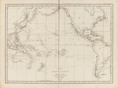
Title
Carte du Grand Océan ou Mer du Sud : dressée pour la Relation du voyage de découvertes faites par les frégates françaises la Boussole et l'Astrolabe dans les années 1785, 86, 87, et 88
Contributor
La Pérouse, Jean-François de Galaup, comte de, 1741-1788
Type
Printed
Barcode
4687820500209
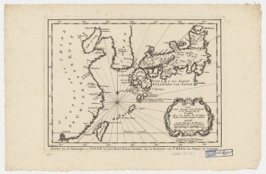
Title
Carte des isles du Japon et la presqu'isle de Coree, avec les costes de la Chine depuis Pekin jusqu'a Canton = Kaart van de Eilanden van Japan, en van't Half-Eiland Koréa ; met de Kusten van China van Pekin tot Canton
Contributor
[Bellin, Jacques Nicolas, 1703-1772, Schley, Jacobus van der, 1715-1779]
Type
Printed
Barcode
4687820500211
Title
Carte d'une partie des côtes de la Chine et des Isles adjacentes : depuis l'Isle nommée la Pierre Blanche, jusqu'a celle de l'Artimon
Contributor
Dalrymple, Alexander, 1737-1808
Type
Printed
Barcode
4687820500212
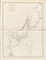
Title
Carte des découvertes faites en 1787 dans les mers de Chine et de Tartarie : par les frégates françaises la Boussole et l'Astrolabe, depuis leur départ de Manille jusqu'à leur arrivée au Kamtschatka
Contributor
La Pérouse, Jean-François de Galaup, comte de, 1741-1788
Type
Printed
Barcode
4687820500215
Title
Nieuwe pascaert van Oost Indien
Contributor
Keulen, Johannes van, 1654-1715
Type
Printed
Barcode
4687820500380
Title
Carte de la Mer du Sud et de la Mer du Nord : ou se trouve les costes d'Amerique, d'Asie, d'Europe et d'Afrique situées sur ces mers. Part 1
Contributor
Fer, Nicolas de, 1646-1720
Type
Printed
Barcode
4687820500489
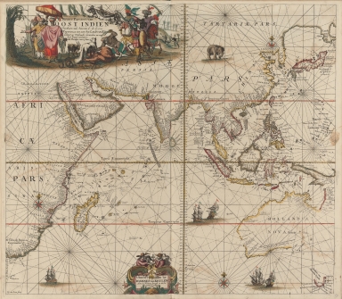
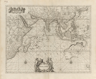
Title
Mar di India
Contributor
Anonymous
Type
Printed
Barcode
4687820500553
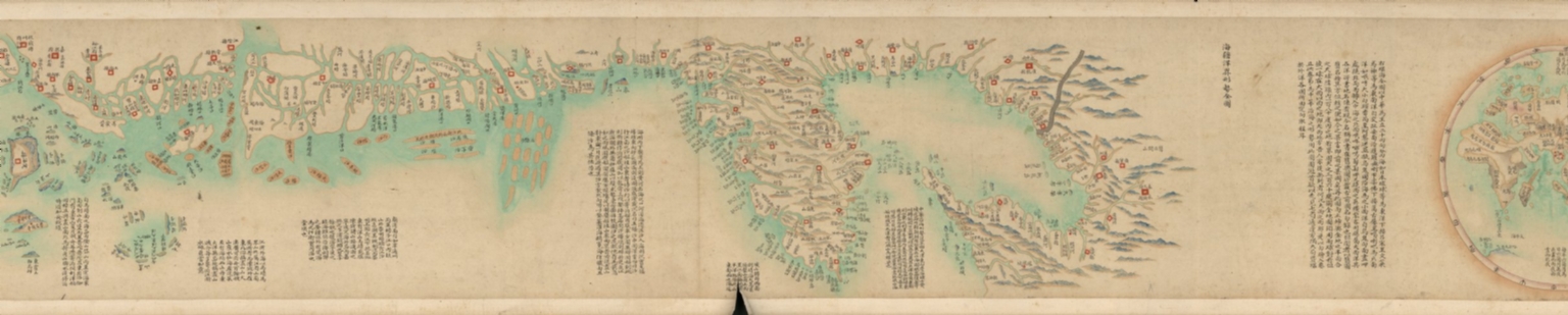
Title
海疆洋界形勢全圖.Part 1 = Coastal map of China.Part 1
Contributor
Anonymous
Type
Manuscripts
Barcode
4687820500554
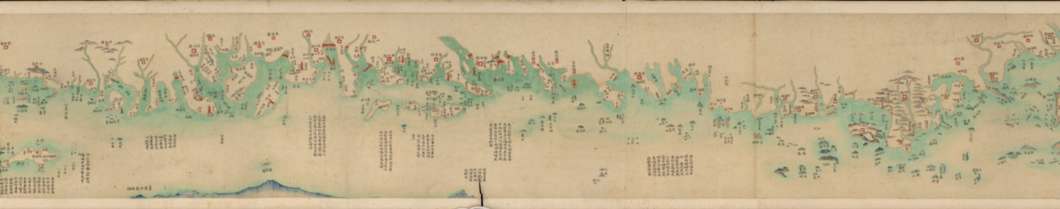
Title
海疆洋界形勢全圖.Part 2 = Coastal map of China.Part 2
Contributor
Anonymous
Type
Manuscripts
Barcode
4687820500555
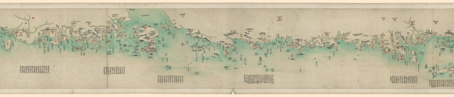
Title
海疆洋界形勢全圖.Part 3 = Coastal map of China.Part 3
Contributor
Anonymous
Type
Manuscripts
Barcode
4687820500556
Title
海疆洋界形勢全圖.Part 4 = Coastal map of China.Part 4
Contributor
Anonymous
Type
Manuscripts
Barcode
4687820500557
Title
海疆洋界形勢全圖.Part 5 = Coastal map of China.Part 5
Contributor
Anonymous
Type
Manuscripts
Barcode
4687820500558
Title
海疆洋界形勢全圖.Part 6 = Coastal map of China.Part 6
Contributor
Anonymous
Type
Manuscripts
Barcode
4687820500564
Title
海疆洋界形勢圖.Part 6
Contributor
Hummel, Arthur W. (Arthur William), 1884-1975
Type
Manuscripts
Barcode
4687820500579
Title
Kaart van de Kust van Quinam, Tonquin en Cochin-China, van R. Cantaon tot aan Punta Lamtaon, benevens het Eyland Aynam en Isla de Pracel
Contributor
Anonymous
Type
Manuscripts
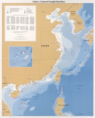
Barcode
4687820500604
Title
China's claimed straight baselines
Contributor
United States. Central Intelligence Agency
Type
Printed
Barcode
4687820500782
Title
A chart of the East India Islands with the coasts of the continent from Caliminera Point to Amoye in China
Contributor
Anonymous
Type
Printed
Barcode
4687820500843
Title
The Pacific Ocean with portions of North and South America, East Indies, part of China
Contributor
Ghisolfi, Francesco
Type
Manuscripts
Barcode
4687820500855
Title
Map of the western Pacific ocean and the Asiatic coast
Contributor
Anonymous
Type
Printed
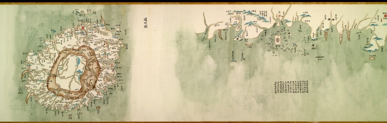
Barcode
4687820500058
Title
中華沿海形勢全圖. Part 1
Contributor
Anonymous
Type
Manuscripts
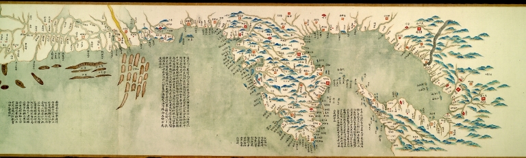
Barcode
4687820500067
Title
中華沿海形勢全圖. Part 10
Contributor
Anonymous
Type
Manuscripts
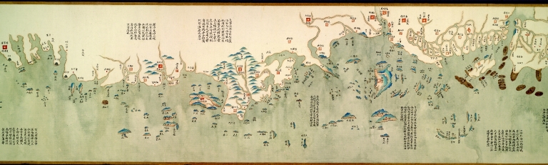
Barcode
4687820500065
Title
中華沿海形勢全圖. Part 8
Contributor
Anonymous
Type
Manuscripts
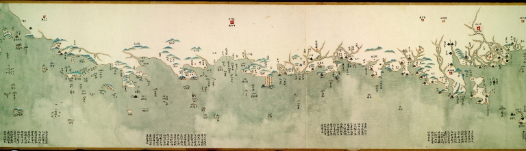
Barcode
4687820500064
Title
中華沿海形勢全圖. Part 7
Contributor
Anonymous
Type
Manuscripts
Barcode
4687820500059
Title
中華沿海形勢全圖. Part 2
Contributor
Anonymous
Type
Manuscripts
Barcode
4687820500060
Title
中華沿海形勢全圖. Part 3
Contributor
Anonymous
Type
Manuscripts
Barcode
4687820500062
Title
中華沿海形勢全圖. Part 5
Contributor
Anonymous
Type
Manuscripts
Barcode
4687820500061
Title
中華沿海形勢全圖. Part 4
Contributor
Anonymous
Type
Manuscripts
Barcode
4687820500063
Title
中華沿海形勢全圖. Part 6
Contributor
Anonymous
Type
Manuscripts
Barcode
4687820500066
Title
中華沿海形勢全圖. Part 9
Contributor
Anonymous
Type
Manuscripts
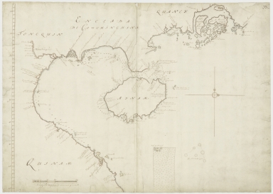
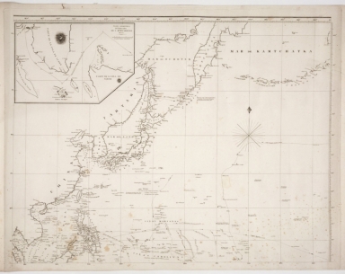
Barcode
4687820500989
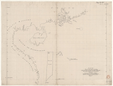
Title
[Plan of Mirs Bay on the coast of China, Chart of the island Lamock, Lamon, Plan of Ping Hai Bay]
Contributor
Murphy, Edward
Type
Manuscripts
Barcode
4687820500131
Title
Carte des côtes de l'Amérique et de l'Asie : depuis la Californie jusqu'à Macao
Contributor
La Pérouse, Jean-François de Galaup, comte de, 1741-1788
Type
Printed
Barcode
4687820500650
Title
明代東西洋航海圖 = The Selden Map
Contributor
Anonymous
Type
Manuscripts
Barcode
4687820500547
Title
七省沿海全圖
Contributor
[Jin, Baoyi, active 19th century, Hummel, Arthur W. (Arthur William), 1884-1975]
Type
Manuscripts
Barcode
4687820500108
Title
The Nauigation of the Portingales into the East Indies, containing their trauels by Sea, into East India, and from the East Indies into Portingall, also from the Portingall Indies to Malacca, China, Iapon, the Islands of Iaua and Sunda ...
Contributor
[Wolfe, John, Phillip, William, Linschoten, Jan Huygen van, 1563-1611]
Type
Printed
Barcode
4687820500450
Title
To John Reeves Esq.re F.R.S. for the liberal aid of his Chinese m.s.s. and the benefit derived from his excellent map of that Empire presented by him to the Hon.ble East India Company this Chart of the East Coast of China
Contributor
[Horsburgh, James, 1762-1836, author, publisher, J. & C. Walker (Firm), engraver, Ross, Daniel, 1780-1849, cartographer, Hall, Basil, 1788-1844, cartographer, Crawford, James H., fl. 18--, cartographer, Rancliffe, George Augustus Henry Anne Parkyns, Baron, 1785-1850, cartographer, Rees, Thomas, 1790-1870, cartographer, Dayot, Félix, 1772-1821, cartographer, Sturgis, Josiah, 1773-1850, cartographer, Rees, John, 1752-18--, cartographer, Hoskiaer, Jacob, 1808-1836, cartographer, Dalrymple, Alexander, 1737-1808, bibliographic antecedent, Reeves, John, 1774-1856, dedicatee]
Type
Printed
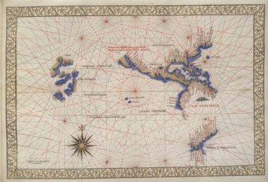
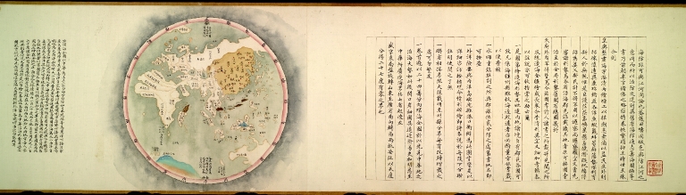
Barcode
4687820501012
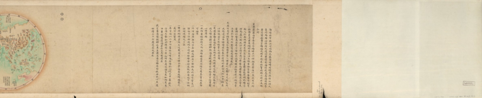
Title
[Indian Ocean from the Cape of Good Hope to Banda and from the Black Sea to Japan, Arabia, Persia, India, Indo-china and Insulinde, South China, Japan]
Contributor
Angelus, author
Type
Manuscripts
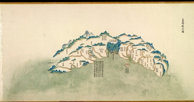
Barcode
4687820501260
Title
[Vues de cotes des mers de Chine]. 1.er
Contributor
Surville, Jean-François de, 1717-1770, author
Type
Manuscripts
Barcode
4687820500218
Title
A chart of the China Sea : inscribed to Mons.r D'Aprés de Mannevillette the ingenious author of the Neptune Oriental, as a tribute due to his labours for the benefit of Navigation, and in acknowledgement of his many signal favours to Dalrymple.
Contributor
[Dalrymple, Alexander, 1737-1808, hydrographer, Demonville, Antoine Guénard, ca. 1733-1797, printer, Malassis, Romain-Nicolas, 1737-1813, printer, Après de Mannevillette, Jean-Baptiste-Nicolas-Denis d', 1707-1780, dedicatee]
Type
Printed
Barcode
4687820501174
Title
Carte d'une partie de la mer de Chine
Contributor
Rosili Mesros, François Etienne de, 1748-1832, bibliographic antecedent
Type
Printed
Barcode
3687800354286H
Title
[Carte d'une partie de la mer de Chine]
Type
Manuscripts
Barcode
3687800354287I
Title
To the Honorable the Court of Directors of the United Company of Merchants of England trading to the East Indies, this Chart of the China Seas
Contributor
[Heather, William, 1764-1812, hydrographer, Stephenson, John,, fl. 1791-1817, engraver, Norie, John William, 1772-1843, illustrator, Heather and Williams, publisher]
Type
Printed
Barcode
4687820501172
Title
[Route de M. de Richery en 1787 de Pondichery a Canton]
Type
Manuscripts
Barcode
4687820501071
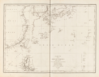
Title
Seconde partie de la carte d'Asie : contenant la Chine, et partie de la Tartarie, l'Inde au delà du Gange, les Isles Sumatra, Java, Borneo, Moluques, Philippines et du Japon. Publiée sous les auspices de Monseigneur Louis-Philippe D'Orléans, Duc D'Orléans, prémier Prince du Sang
Contributor
Anville, Jean Baptiste Bourguignon d', 1697-1782, cartographer
Type
Manuscripts
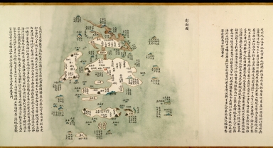
Barcode
4687820501015
Title
Carte pour la navigation des mers entre les cotes de Chine et du Blanc le Paracel et de celles du Golfe de Cochinchine : dressée sur une carte MS.te a M.r Bouvet qui contenoit depuis le 2.e deg. jusq.' 24.e dont cette 1.ere feuille ne comprend que du 24.e au 13.e degré.
Contributor
Bouvet, 16---17--, bibliographic antecedent
Type
Manuscripts
Barcode
4687820501075
Title
Carte des Indes et de la Chine : dressée sur plusieurs relations particulières rectifiées par quelques observations
Contributor
[Delisle, Guillaume, 1675-1726, cartographer, publisher, Renard, Louis, ca. 1678-1746, publisher]
Type
Manuscripts
Barcode
4687820501077
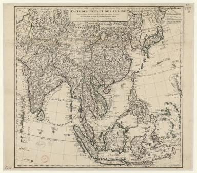
Title
Carte generale de la Chine : dressée sur les cartes particulieres que l'Empereur Cang-hi a fait lever sur les lieux par les RR. PP. Jesuites mission[n]aires dans cet Empire
Contributor
[Anville, Jean Baptiste Bourguignon d', 1697-1782, cartographer, Gravelot, Hubert-François, 1699-1773, illustrator, engraver, Delahaye, Jean Baptiste, fl. 1721-1723, engraver]
Type
Manuscripts
|


![[Plan of Mirs Bay on the coast of China, Chart of the island Lamock, Lamon, Plan of Ping Hai Bay]](http://lunamap.must.edu.mo:80/MediaManager/srvr?mediafile=/Size2/MUST~2~2/54/GE+SH+18+PF+179+DIV+14+P+1+D+-+Plan+of+Mirs+Bay+on+the+coast+of+China+-+Plan+of+Ping+Hai+Bay.jpg)

![[Indian Ocean from the Cape of Good Hope to Banda and from the Black Sea to Japan, Arabia, Persia, India, Indo-china and Insulinde, South China, Japan]](http://lunamap.must.edu.mo:80/MediaManager/srvr?mediafile=/Size2/MUST~2~2/54/FRANCAIS+9669+-+fol+8v-9.jpg)
![[Vues de cotes des mers de Chine]. 1.er](http://lunamap.must.edu.mo:80/MediaManager/srvr?mediafile=/Size1/MUST~2~2/54/GE+SH+18+PF+183+DIV+1+P+1+%28PL+1%29.jpg)

![[Carte d'une partie de la mer de Chine]](http://lunamap.must.edu.mo:80/MediaManager/srvr?mediafile=/Size2/MUST~2~2/54/GE+SH+18+PF+182+P+11+D_Carte+d%27une+partie+de+la+mer+de+Chine.jpg)

![[Route de M. de Richery en 1787 de Pondichery a Canton]](http://lunamap.must.edu.mo:80/MediaManager/srvr?mediafile=/Size2/MUST~2~2/54/GE+SH+18+PF+182+P+6+D_Routes+de+M+de+Richery+en+1787.jpg)

![Carte generale de la Chine : dressée sur les cartes particulieres que l'Empereur Cang-hi a fait lever sur les lieux par les RR. PP. Jesuites mission[n]aires dans cet Empire](http://lunamap.must.edu.mo:80/MediaManager/srvr?mediafile=/Size2/MUST~2~2/54/GE+C-8817.jpg)