REMOVEWHEN |
REFINE
Browse All : Nautical charts by Rees, Thomas, 1790-1870, cartographer and Hall, Basil, 1788-1844, cartographer and Dayot, Félix, 1772-1821, cartographer and Ross, Daniel, 1780-1849, cartographer of China and Korea and Yellow Sea from 1835
1-1 of 1
Barcode
4687820500852
Title
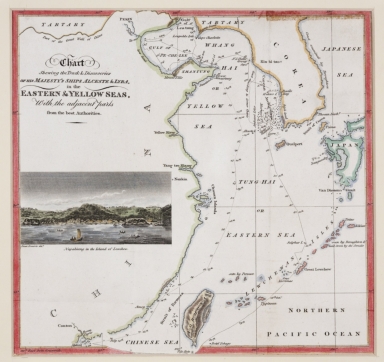
Chart shewing the track & discoveries of his Majesty's ships Alceste & Lyra, in the Eastern & Yellow Seas, with the adjacent parts from the best authorities.
Contributor
[Murray, John, 1778-1843, author, printer, Dwarris, Fortunatus, Sir, 1786-1860, illustrator]
Type
Printed
1-1 of 1
|