|
REFINE
Browse All : Images by Baker, B. (Benjamin), active 1766-1824 from 1796
1-2 of 2
Barcode
4687820500220
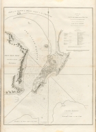
Title
A plan of the city and harbour of Macao : a colony of the Portugueze, situated at the southern extremity of the Chinese Empire in Lat. 22 ⁰12ʹ44ʺ N., long. 113°35ʹ0ʺ east of Greenwich
Contributor
Baker, B. (Benjamin), active 1766-1824
Type
Printed
Barcode
4687820500792
Title
A general chart, on Mercator's projection, to shew the track of the Lion and Hindostan from England to the Gulph of Pekin in China, and of their return to England : with the daily statement of the barometer and thermometer as observed at noon: containing also the limits of the Chinese Empire as extended by the conquests of the present Emperor Tchien-Lung
Contributor
[Barrow, John, Baker, B. (Benjamin), active 1766-1824]
Type
Printed
1-2 of 2
|