|
REFINE
Browse All : Images of Philippines and South China Sea and China and Sumatra (Indonesia)
1-3 of 3
Barcode
4687820501172
Title
[Route de M. de Richery en 1787 de Pondichery a Canton]
Type
Manuscripts
Barcode
4687820501071
Title
Seconde partie de la carte d'Asie : contenant la Chine, et partie de la Tartarie, l'Inde au delà du Gange, les Isles Sumatra, Java, Borneo, Moluques, Philippines et du Japon. Publiée sous les auspices de Monseigneur Louis-Philippe D'Orléans, Duc D'Orléans, prémier Prince du Sang
Contributor
Anville, Jean Baptiste Bourguignon d', 1697-1782, cartographer
Type
Manuscripts
Barcode
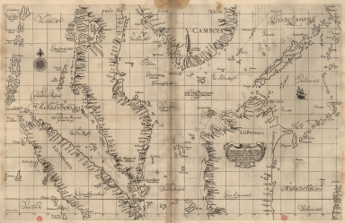
3687800354466H
Title
Particular map of Malacca with the coast from Pegu, Cambodia with the Islands of Sumatra and northern part of Borneo many other surrounding islands and islets
Contributor
[Dudley, Robert, Sir, 1574-1649, cartographer, Lucini, Antonio Francesco, 1605-1640, engraver, Onofri, Francesco, fl. 1631-1679, printer]
Type
Printed
1-3 of 3
|
![[Route de M. de Richery en 1787 de Pondichery a Canton]](http://lunamap.must.edu.mo:80/MediaManager/srvr?mediafile=/Size2/MUST~2~2/54/GE+SH+18+PF+182+P+6+D_Routes+de+M+de+Richery+en+1787.jpg)