|
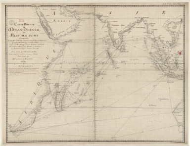
Barcode
36878003222413
Title
Carte reduite de l'Ocean-Oriental ou Mers des Indes : contenant les costes d Afrique dépuis le cap de Bonne-Espérance, jusqu'a la Mer Rouge, et celles d'Asie dépuis la Mer Rouge, jusqu'a Canton en Chine : Avec les Isles de Madagascar, Bourbon, et de France, les Maldives, I. Ceylan, Sumatra, Java, &.a Pour servir aux vaisseaux du Roy
Contributor
[Le Moyne, François-Pierre, 1713-1795, cartographer, Maurepas, Jean-Frédéric Phélypeaux, comte de, 1701-1781, patron]
Type
Manuscripts
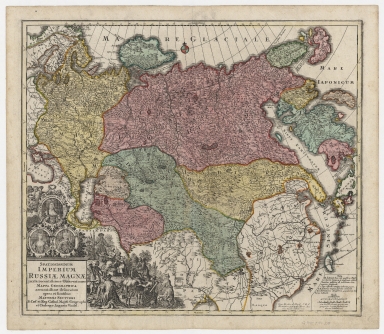
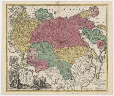
Barcode
4687820500441
Title
Spatiosissimum imperium Russiæ Magnæ, iuxta recentissimas observationes, mappa geographica accuratissime delineatum
Contributor
Seutter, Matthaeus, 1678-1756
Type
Printed
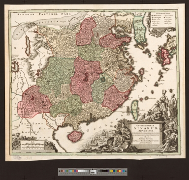
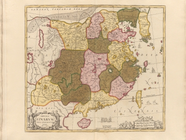
Barcode
4687820500069
Title
Opulentissimum sinarum imperium juxta recentissimam delineationem in suas provincias disterminatum
Contributor
Seutter, Matthaeus, 1678-1756
Type
Printed
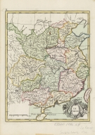
Barcode
4687820500312
Title
La Chine
Contributor
Le Rouge, Georges-Louis
Type
Printed
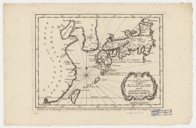
Barcode
4687820500209
Title
Carte des isles du Japon et la presqu'isle de Coree, avec les costes de la Chine depuis Pekin jusqu'a Canton = Kaart van de Eilanden van Japan, en van't Half-Eiland Koréa ; met de Kusten van China van Pekin tot Canton
Contributor
[Bellin, Jacques Nicolas, 1703-1772, Schley, Jacobus van der, 1715-1779]
Type
Printed
Barcode
4687820500786
Title
A new & accurate map of China : drawn from surveys made by Jesuit missionaries by order of the Emperor : the whole being regulated by numerous astronomical observations
Contributor
Bowen, Emanuel, -1767
Type
Printed
Barcode
4687820500344
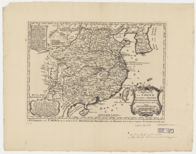
Title
L'empire de la Chine pour servir a l'Histoire generale des voyages = Keizerryk van China, om te dienen tot de Historische Beschryving der Reizen
Contributor
[Bellin, Jacques Nicolas, 1703-1772, Schley, Jacobus van der, 1715-1779]
Type
Printed
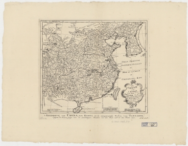
Barcode
4687820500351
Title
La Chine avec la Korée, et les parties de la Tartarie les plus voisines : tirées des cartes que les Jesuites Missionaires ont levées les années 1708, jusqu'en 1717 = Keyzerryk van China, met Korea, en de aangrenzende deelen van Tartarye
Contributor
[Bellin, Jacques Nicolas, 1703-1772, Hondt, Pieter de, Schley, Jacobus van der, 1715-1779]
Type
Printed
Barcode
4687820500122
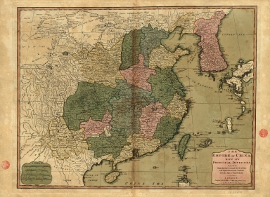
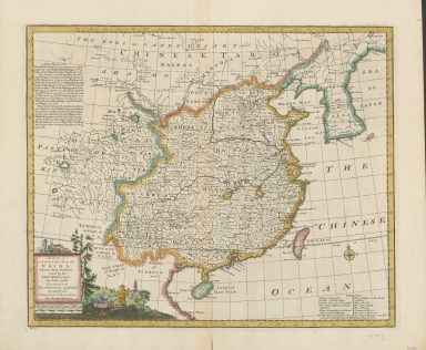
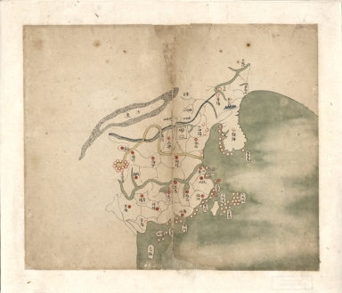
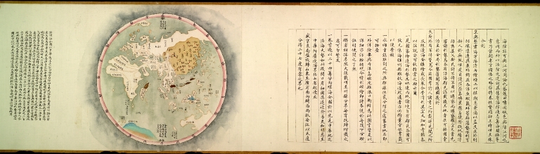
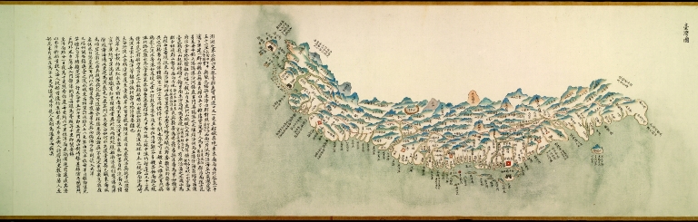
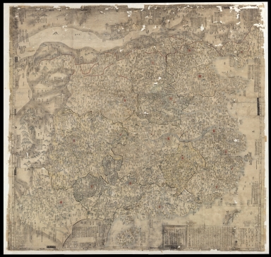
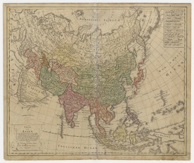
Title
[Northeastern Asia]
Contributor
Anville, Jean Baptiste Bourguignon d', 1697-1782
Type
Printed
Barcode
4687820501164
Title
Carte des provinces de Chine
Contributor
陸寅生
Type
Printed
Barcode
4687820501071
Title
Seconde partie de la carte d'Asie : contenant la Chine, et partie de la Tartarie, l'Inde au delà du Gange, les Isles Sumatra, Java, Borneo, Moluques, Philippines et du Japon. Publiée sous les auspices de Monseigneur Louis-Philippe D'Orléans, Duc D'Orléans, prémier Prince du Sang
Contributor
Anville, Jean Baptiste Bourguignon d', 1697-1782, cartographer
Type
Manuscripts
Barcode
4687820500752
Title
大清分省輿圖總圖 = Provincial atlas of the great Qing Dynasty
Contributor
Anonymous
Type
Manuscripts
Barcode
4687820500330
Title
Imperii Sinarum nova descriptio
Contributor
Loon, J. van, approximately 1611-1686
Type
Printed
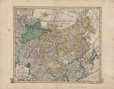
Barcode
4687820500427
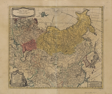
Title
Spatiosissimum Imperium Russiae magnae iuxta recentissimas observationes mappa geographica
Contributor
Lotter, Tobias Conrad, 1717-1777
Type
Printed
Barcode
4687820500340
Title
Tab. Geogr. Imperii Russici : ad emendatiora adhuc edita exempla jussu Acad. Reg. Scient. et eleg. Litt. Boruss. descripta
Contributor
Euler, Leonhard, 1707-1783
Type
Printed
Barcode
4687820501175
Title
A chart of the China Sea : inscribed to Mons.r d'Aprés de Mannevillette the ingenious author of the Neptune Oriental, as a tribute due to his labours for the benefit of navigation, and in acknowledgment of his many signal favours to A. Dalrymple.
Contributor
[Dalrymple, Alexander, 1737-1808, hydrographer, Henry, B., fl. 1770-1775, engraver, Whitchurch, William, fl. 18th century, engraver, Lane, Bartholomew, fl. 19th century, engraver, Après de Mannevillette, Jean-Baptiste-Nicolas-Denis d', 1707-1780, dedicatee]
Type
Printed
Barcode
4687820500058
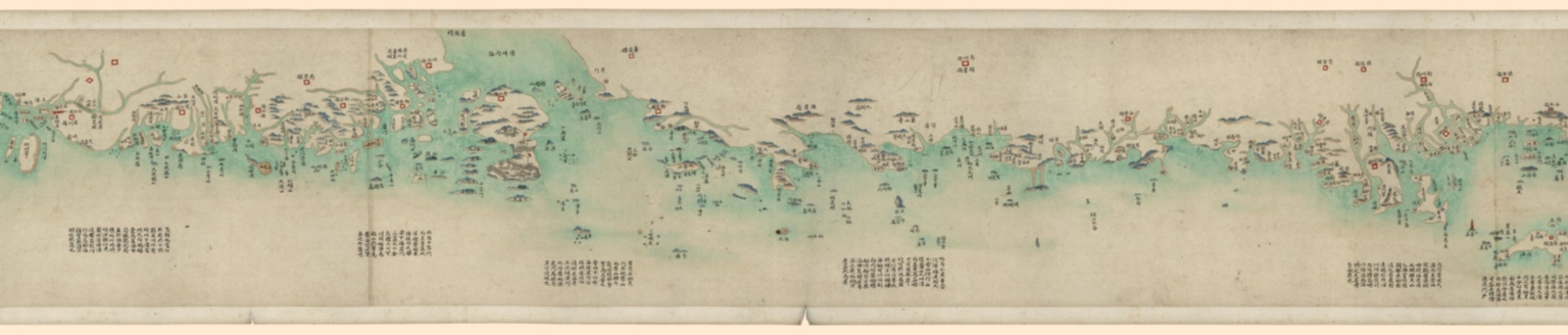
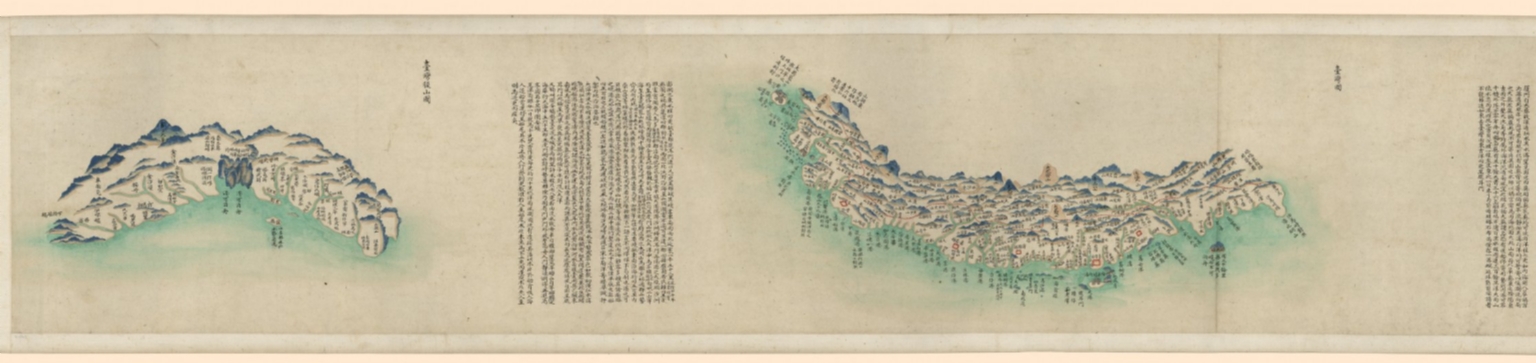
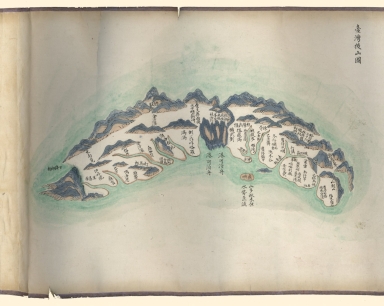
Title
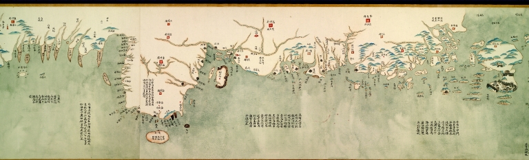
中華沿海形勢全圖. Part 1
Contributor
Anonymous
Type
Manuscripts
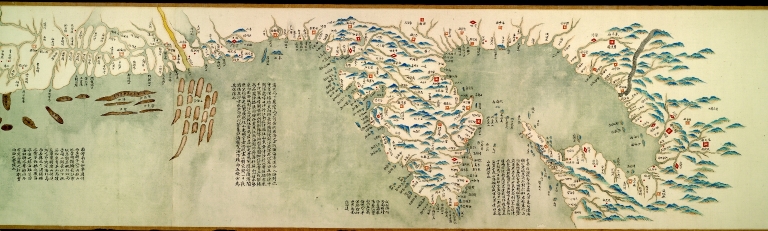
Barcode
4687820500067
Title
中華沿海形勢全圖. Part 10
Contributor
Anonymous
Type
Manuscripts
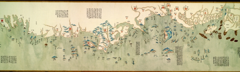
Barcode
4687820500065
Title
中華沿海形勢全圖. Part 8
Contributor
Anonymous
Type
Manuscripts
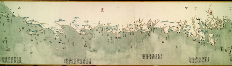
Barcode
4687820500064
Title
中華沿海形勢全圖. Part 7
Contributor
Anonymous
Type
Manuscripts
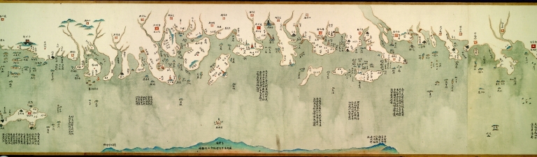
Barcode
4687820500059
Title
中華沿海形勢全圖. Part 2
Contributor
Anonymous
Type
Manuscripts
Barcode
4687820500060
Title
中華沿海形勢全圖. Part 3
Contributor
Anonymous
Type
Manuscripts
Barcode
4687820500062
Title
中華沿海形勢全圖. Part 5
Contributor
Anonymous
Type
Manuscripts
Barcode
4687820500061
Title
中華沿海形勢全圖. Part 4
Contributor
Anonymous
Type
Manuscripts
Barcode
4687820500063
Title
中華沿海形勢全圖. Part 6
Contributor
Anonymous
Type
Manuscripts
Barcode
4687820500066
Title
中華沿海形勢全圖. Part 9
Contributor
Anonymous
Type
Manuscripts
Barcode
4687820500211
Title
Carte d'une partie des côtes de la Chine et des Isles adjacentes : depuis l'Isle nommée la Pierre Blanche, jusqu'a celle de l'Artimon
Contributor
Dalrymple, Alexander, 1737-1808
Type
Printed
Barcode
4687820500782
Title
A chart of the East India Islands with the coasts of the continent from Caliminera Point to Amoye in China
Contributor
Anonymous
Type
Printed
Barcode
3687800354652E
Title
Views of the coasts of China
Contributor
[Great Britain. Hydrographic Office, author, Dalrymple, Alexander, 1737-1808, publisher]
Type
Printed
Barcode
4687820500422
Title
Nova mappa generalis totius orbis amplissimae Russorum Monarchiae = Nouvelle carte d'Empire de Russie et de Tartarie, grande et petite en Europe et en Asie
Contributor
[Probst, Johann Michael, -1809, Probst, Johann Georg, 1759-1809]
Type
Printed
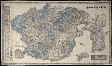
Barcode
4687820501108
Title
大清廣輿圖 = Carte de la Chine sous la dynastie Ts'ing
Contributor
[Nagakubo, Sekisui, 1717-1801, 程赤城, 蔡方炳, 1626-1709]
Type
Printed
Barcode
4687820501178
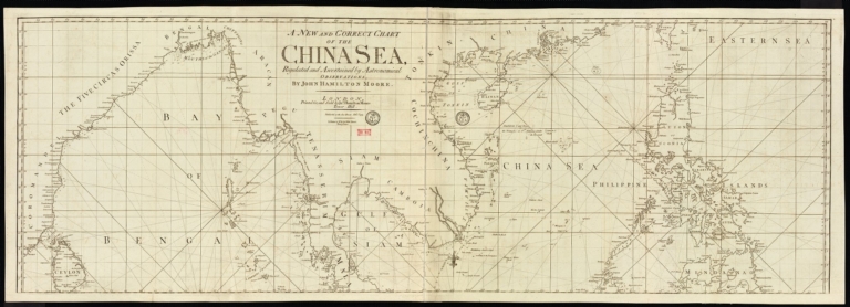
Title
A new and correct chart of the China Sea
Contributor
[Moore, John Hamilton, 1738-1807, cartographer, Blake, T. J., fl. 1785-1785, engraver]
Type
Printed
Barcode
4687820500132
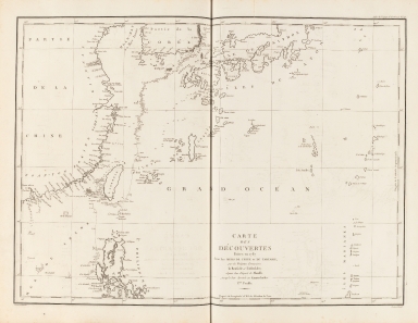
Title
Carte Générale Des Découvertes faites en 1787 dans les Mers De Chine et De Tartarie ou depuis Manille jusqu'à Avatscha : par les Frégates Françaises la Boussole et l'Astrolabe
Contributor
La Pérouse, Jean-François de Galaup, comte de, 1741-1788
Type
Printed
Barcode
4687820500212
Title
Carte des découvertes faites en 1787 dans les mers de Chine et de Tartarie : par les frégates françaises la Boussole et l'Astrolabe, depuis leur départ de Manille jusqu'à leur arrivée au Kamtschatka
Contributor
La Pérouse, Jean-François de Galaup, comte de, 1741-1788
Type
Printed
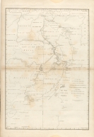
Barcode
4687820501172
Title
[Route de M. de Richery en 1787 de Pondichery a Canton]
Type
Manuscripts
Barcode
4687820500553
Title
海疆洋界形勢全圖.Part 1 = Coastal map of China.Part 1
Contributor
Anonymous
Type
Manuscripts
Barcode
4687820500554
Title
海疆洋界形勢全圖.Part 2 = Coastal map of China.Part 2
Contributor
Anonymous
Type
Manuscripts
Barcode
4687820500555
Title
海疆洋界形勢全圖.Part 3 = Coastal map of China.Part 3
Contributor
Anonymous
Type
Manuscripts
Barcode
4687820500556
Title
海疆洋界形勢全圖.Part 4 = Coastal map of China.Part 4
Contributor
Anonymous
Type
Manuscripts
Barcode
4687820500557
Title
海疆洋界形勢全圖.Part 5 = Coastal map of China.Part 5
Contributor
Anonymous
Type
Manuscripts
Barcode
4687820500558
Title
海疆洋界形勢全圖.Part 6 = Coastal map of China.Part 6
Contributor
Anonymous
Type
Manuscripts
Barcode
4687820500564
Title
海疆洋界形勢圖.Part 6
Contributor
Hummel, Arthur W. (Arthur William), 1884-1975
Type
Manuscripts
Barcode
4687820500677
Title
京版天文全圖 = Complete map of astronomy and the Qing Empire
Contributor
[馬俊良, active 18th century-19th century, 黄宗羲, 1610-1695]
Type
Printed
Barcode
36878003222312
Title
To the Society of Managing Owners of the Ships in the English East India Company's Service, This Chart of the China Sea, Including the Philippina Molluca and Banda Islands, Shewing al the same time all the Tracks into the Pacific Ocean, commonly known by the name of the Eastern Passage to China
Contributor
[Robertson, George, 1748-1788, cartographer, Harmer, Thomas, fl. 1784-1814, engraver]
Type
Printed
Barcode
4687820500391
Title
Charte von Asien : nach den bewährtesten astronomischen Beobachtungen den neuesten Reisen, und den vorzüglichsten Charten, insonderheit aber der Geographie de Hrn I.C. Gatterers. gemäss
Contributor
[Güssefeld, F. L. (Franz Ludwig), 1744-1807, Homann Erben (Firm)]
Type
Printed
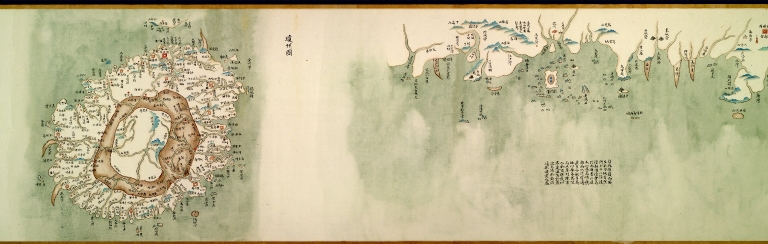
Barcode
4687820500989
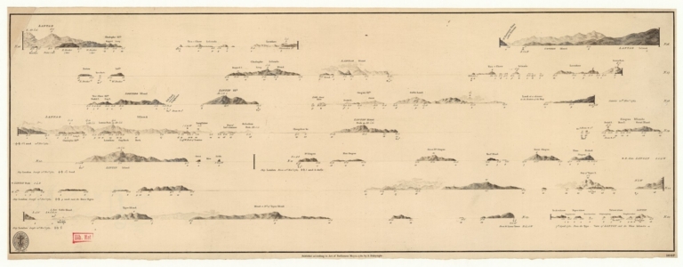
Title
[Plan of Mirs Bay on the coast of China, Chart of the island Lamock, Lamon, Plan of Ping Hai Bay]
Contributor
Murphy, Edward
Type
Manuscripts
Barcode
3687800354473F
Title
The Empire of China with its principal divisions : drawn from the surveys made by the Jesuits, with improvements and additions from the maps of Mons.r D'Anville.
Contributor
[Anville, Jean Baptiste Bourguignon d', 1697-1782, bibliographic antecedent, Bowen, Maurice, fl. ca. 1780-1794, engraver, Whittle & Laurie, publisher]
Type
Printed
Barcode
3687800301756B
Title
A new chart of the oriental seas and islands with the coasts of the continent from the Isle of Ceylon to Amoye in China
Contributor
[Après de Mannevillette, Jean-Baptiste-Nicolas-Denis d', 1707-1780, cartographer, Laurie & Whittle, publisher]
Type
Printed
Barcode
3687800301791A
Title
A chart, on Mercator's projection, containing the track and soundings of the Lion, the Hindostan and Tenders, from Turon-Bay in Cochin-China to the mouth of the Pei-Ho River in the Gulph of Pe-Tche-Lee or Pekin
Contributor
[Barrow, John, 1764-1848, cartographer, Baker, Benjamin, fl. 1780-1824, engraver, Nicol, George, ca. 1740-1828, publisher]
Type
Printed
Barcode
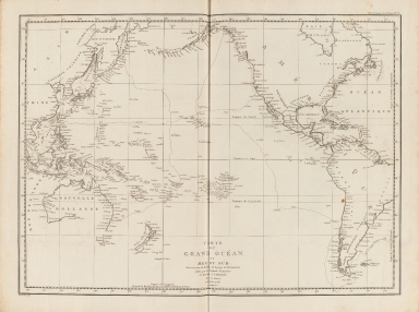
4687820500208
Title
Carte du Grand Océan ou Mer du Sud : dressée pour la Relation du voyage de découvertes faites par les frégates françaises la Boussole et l'Astrolabe dans les années 1785, 86, 87, et 88
Contributor
La Pérouse, Jean-François de Galaup, comte de, 1741-1788
Type
Printed
|
![[Northeastern Asia]](http://lunamap.must.edu.mo:80/MediaManager/srvr?mediafile=/Size1/MUST~2~2/41/G7800_1750_A5%C3%A5%C2%89%C2%AF%C3%A6%C2%9C%C2%AC.jpg)


![[Route de M. de Richery en 1787 de Pondichery a Canton]](http://lunamap.must.edu.mo:80/MediaManager/srvr?mediafile=/Size2/MUST~2~2/54/GE+SH+18+PF+182+P+6+D_Routes+de+M+de+Richery+en+1787.jpg)


![[Plan of Mirs Bay on the coast of China, Chart of the island Lamock, Lamon, Plan of Ping Hai Bay]](http://lunamap.must.edu.mo:80/MediaManager/srvr?mediafile=/Size2/MUST~2~2/54/GE+SH+18+PF+179+DIV+14+P+1+D+-+Plan+of+Mirs+Bay+on+the+coast+of+China+-+Plan+of+Ping+Hai+Bay.jpg)