|
REFINE
Browse All : Sea Charts of Timor Island
1-7 of 7
Barcode
3687800354289K
Title
To the Honorable the Court of Directors of the United Company of Merchants of England trading to the East Indies, this Chart of the China Seas
Contributor
[Heather, William, 1764-1812, hydrographer, Stephenson, John,, fl. 1791-1817, engraver, Norie, John William, 1772-1843, illustrator, Heather and Williams, publisher]
Type
Printed
Barcode
4687820501071
Title
Seconde partie de la carte d'Asie : contenant la Chine, et partie de la Tartarie, l'Inde au delà du Gange, les Isles Sumatra, Java, Borneo, Moluques, Philippines et du Japon. Publiée sous les auspices de Monseigneur Louis-Philippe D'Orléans, Duc D'Orléans, prémier Prince du Sang
Contributor
Anville, Jean Baptiste Bourguignon d', 1697-1782, cartographer
Type
Manuscripts
Barcode
4687820501075
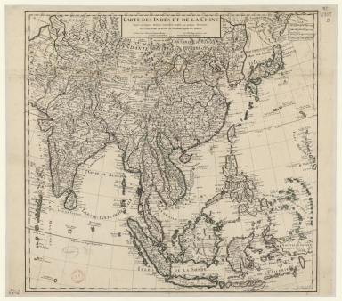
Title
Carte des Indes et de la Chine : dressée sur plusieurs relations particulières rectifiées par quelques observations
Contributor
[Delisle, Guillaume, 1675-1726, cartographer, publisher, Renard, Louis, ca. 1678-1746, publisher]
Type
Manuscripts
Barcode
4687820501171
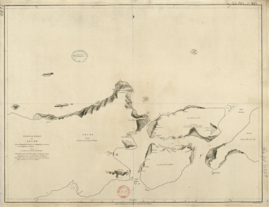
Title
Chart of the Strait of Solor : from a Portuguese ms used by the Portuguese of Macao in the navigation to Timor
Contributor
[Harmer, Thomas, fl. 1784-1814, engraver, Dalrymple, Alexander, 1737-1808, publisher]
Type
Printed
Barcode
4687820500985
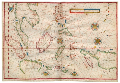
Title
China Sea and West Pacific Ocean
Contributor
[Albernaz, João Teixeira, fl. 1602-1649, cartographer, Berry, Marie-Caroline de Bourbon-Sicile, duchesse de, 1798-1870, former owner, Aunay, Jean-Charles de Mesgrigny d', comte, 1680-1763, former owner]
Type
Manuscripts
Barcode
4687820500914
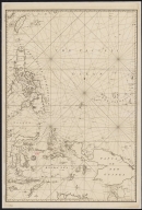
Title
[East Indies, including a large "Java Maior" (Australia?) and coast of Asia]
Contributor
[Oliva, Bartolomeo, 1538-1588, cartographer, Phillipps, Thomas, Sir, 1792-1872, former owner]
Type
Manuscripts
Barcode
36878003222312
Title
To the Society of Managing Owners of the Ships in the English East India Company's Service, This Chart of the China Sea, Including the Philippina Molluca and Banda Islands, Shewing al the same time all the Tracks into the Pacific Ocean, commonly known by the name of the Eastern Passage to China
Contributor
[Robertson, George, 1748-1788, cartographer, Harmer, Thomas, fl. 1784-1814, engraver]
Type
Printed
1-7 of 7
|

![[East Indies, including a large "Java Maior" (Australia?) and coast of Asia]](http://lunamap.must.edu.mo:80/MediaManager/srvr?mediafile=/Size2/MUST~2~2/45/000358.jpg)
