|
REFINE
Browse All : Printed of Pacific Ocean and Indian Ocean
1-2 of 2
Barcode
4687820500350
Title
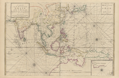
Carte des costes de l'Asie sur l'Ocean : contenant les bancs isles et costes & c, levee sur les memoires les plus nouveau
Contributor
Mortier, Pierre, 1661-1711
Type
Printed
Barcode
4687820500791
Title
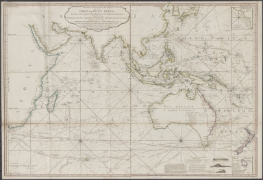
Laurie and Whittle's New chart of the Indian and Pacific Oceans between the Cape of Good Hope, New Holland and Japan : comprehending New Zealand, New Caledonia, New Britain, New Ireland, New Guinea &c., Louisiade and New Georgia; also The Pelew, New Caroline, Ladrone and Philippine Islands &c. with the most remarkable tracks of the English, Spanish, French and Dutch navigators and chiefly the track of the Walpole, EastIndiaman, Captn. Thos. Butler, 1794 from the Cape of Good Hope to Van Diemen's Land and from thence to China, and the track of the Royal Admiral Captn. Henr. Bond in 1792 and 93 from the Cape to Port Jackson and China
Contributor
Laurie & Whittle
Type
Printed
1-2 of 2
|