|
REFINE
Browse All : Printed of Hainan Sheng (China)
1-41 of 41
Barcode
4687820500103
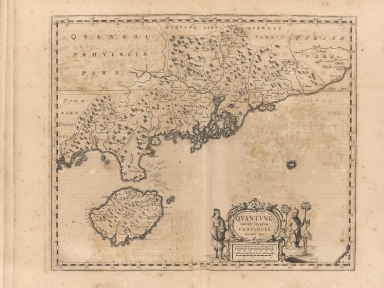
Title
Quantung, imperii Sinarum provincia duodecima
Contributor
Martini, Martino, 1614-1661
Type
Printed
Barcode
4687820500496
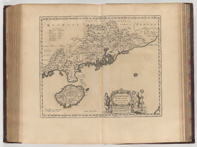
Title
Quantung, imperii sinarum provincia duodecima
Contributor
Blaeu, Joan, 1596-1673
Type
Printed
Barcode
4687820500536
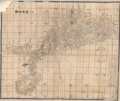
Title
廣東全圖 = Complete map of Guangdong Province
Contributor
湖北省 (中國). 官書局
Type
Printed
Barcode
4687820500092
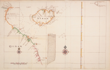
Title
Map of the coasts of Annam and the island of Hainan
Contributor
Vinckeboons, Joan
Type
Printed
Barcode
4687820500105
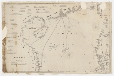
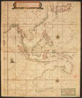
Title
China Sea. Sheet II
Contributor
Horsburgh, James, 1762-1836, cartographer, publisher
Type
Printed
Barcode
4687820500050
Title
China Sea. Sheet 1.st to James Drummond Esquire in acknowledgement for his laudable endeavours towards perfecting the navigation of the China Sea
Contributor
[Horsburgh, James, 1762-1836, cartographer, publisher, James Drummond, 8th Viscount Strathallan, 1767-1851, dedicatee]
Type
Printed
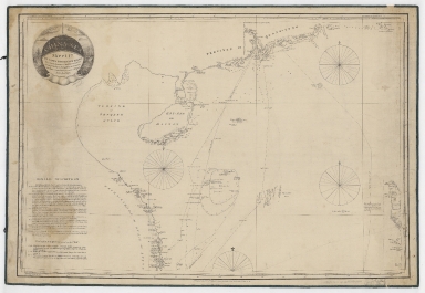
Barcode
4687820500255
Title
A chart of the south coast of Hay-nan, from Tinhosa to Guichou
Contributor
[Haldane, John, captain, fl. 177-, cartographer, Laurie & Whittle, publisher]
Type
Printed
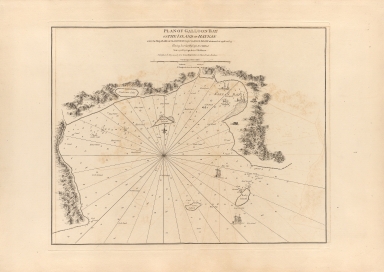
Barcode
4687820500254
Title
Plan of Galloon Bay on the Island of Hay-nan : where the ship Earl of Sandwich Cap.t Charles Deane winteres in 1776 and 77 having lost her passage to China
Contributor
[Haldane, John, captain, fl. 177-, cartographer, Whittle & Laurie, publisher]
Type
Printed
Barcode
4687820500328
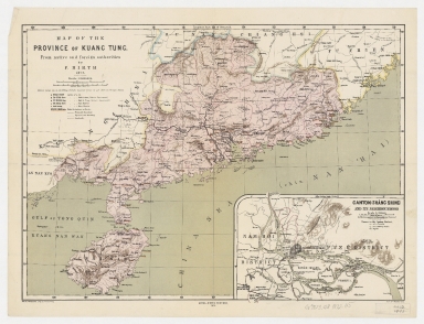
Title
Map of the province of Kuang Tung : from native and foreign authorities
Contributor
[Hirth, Friedrich, 1845-1927, cartographer, Petermann, August, 1822-1878, engraver, Peip, Christian, 1843-1922, engraver, Domann, Bruno, 1854-1920, engraver, Hellfarth, Carl, 1846-1918, printer, Justus Perthes (Firm : Gotha, Germany), publisher]
Type
Printed
Barcode
4687820500218
Title
A chart of the China Sea : inscribed to Mons.r D'Aprés de Mannevillette the ingenious author of the Neptune Oriental, as a tribute due to his labours for the benefit of Navigation, and in acknowledgement of his many signal favours to Dalrymple.
Contributor
[Dalrymple, Alexander, 1737-1808, hydrographer, Demonville, Antoine Guénard, ca. 1733-1797, printer, Malassis, Romain-Nicolas, 1737-1813, printer, Après de Mannevillette, Jean-Baptiste-Nicolas-Denis d', 1707-1780, dedicatee]
Type
Printed
Barcode
4687820501174
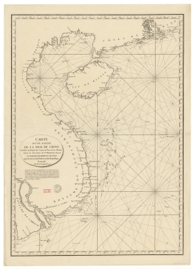
Title
Carte d'une partie de la mer de Chine
Contributor
Rosili Mesros, François Etienne de, 1748-1832, bibliographic antecedent
Type
Printed
Barcode
3687800354287I
Title
To the Honorable the Court of Directors of the United Company of Merchants of England trading to the East Indies, this Chart of the China Seas
Contributor
[Heather, William, 1764-1812, hydrographer, Stephenson, John,, fl. 1791-1817, engraver, Norie, John William, 1772-1843, illustrator, Heather and Williams, publisher]
Type
Printed
Barcode
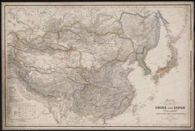
4687820501246
Title
Karte von China und Japan : den manen D'Anville's und Klapproth's gewidmet
Contributor
[Mädel, Carl Joseph, fl. 1819-1859, engraver, Justus Perthes (Firm : Gotha, Germany), publisher]
Type
Printed
Barcode
4687820500336
Title
A new chart of the China Sea, with its several entrances : drawn from a great number of draughts, journals, and other National documents, regulated by astronomical observations
Contributor
[Laurie & Whittle, author, publisher, Larkins, John Pascal, 17---1794, cartographer, Rees, Captain, cartographer]
Type
Printed
Barcode
3687800354267G
Title
A new chart of the China Sea, with its several entrances : drawn from a great number of draughts, journals, and other National documents, regulated by astronomical observation
Contributor
[Laurie & Whittle, author, publisher, Larkins, John Pascal, 17---1794, cartographer, Rees, Captain, cartographer]
Type
Printed
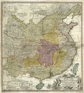
Barcode
4687820501078
Title
Carte generale de la Chine : dressée sur les cartes particulieres que l'Empereur Cang-hi a fait lever sur les lieux par les RR. PP. Jesuites mission[n]aires dans cet Empire
Contributor
[Anville, Jean Baptiste Bourguignon d', 1697-1782, cartographer, Gravelot, Hubert-François, 1699-1773, illustrator, engraver, Delahaye, Jean Baptiste, fl. 1721-1723, engraver]
Type
Printed
Barcode
4687820501236
Title
Map of China, and a description of the work of missionaries in China
Contributor
[Hase, Johann Matthias, 1684-1742, author, Anville, Jean Baptiste Bourguignon d', 1697-1782, bibliographic antecedent, Homann Erben (Firm), printer]
Type
Printed
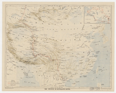
Barcode
4687820500335
Title
Map showing M. Bonvalot's route
Contributor
Erhard Bros. (Firm), engraver
Type
Printed
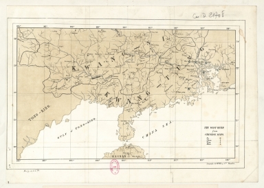
Barcode
4687820501167
Title
The West River from Chinese maps
Contributor
Litografía de Oppel y Compañía (Manila) lithographer
Type
Printed
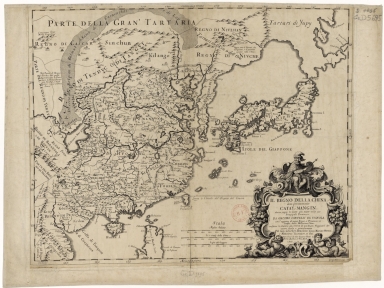
Barcode
4687820501105
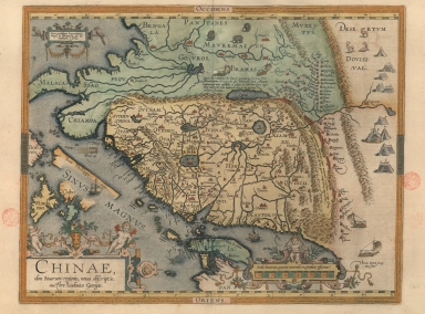
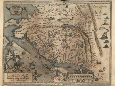
Title
Il regno della China detto presentemente Catay, e Mangin, diviso sopra le Carte piú esatte nelle sue Principle Provincie
Contributor
[Cantelli, Giacomo, 1643-1695, cartographer, Grueber, Johann, 1623-1680 bibliographic antecedent, Góis, Bento de, 1562-1607, bibliographic antecedent, Martini, Martino, 1614-1661, bibliographic antecedent, Tavernier, Jean-Baptiste, 1605-1689, bibliographic antecedent, Widman, Georgio, fl. 1705, engraver, Rossi, Giovanni Giacomo de, 1627-1691, printer]
Type
Printed
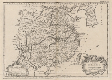
Barcode
4687820500202
Title
L'Empire de la Chine
Contributor
Bellin, Jacques-Nicolas, 1703-1772, cartographer
Type
Printed
Barcode
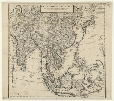
3687800354316B
Title
Carte des Indes et de la Chine : dressée sur plusieurs relations particulières rectifiées par quelques observations
Contributor
[Delisle, Guillaume, 1675-1726, publisher, Renard, Louis, ca. 1678-1746, publisher]
Type
Printed
Barcode
36878003544319
Title
Railway map of China : Peking, Oct. 1918
Contributor
[United States. Bureau of Foreign and Domestic Commerce, author, Whitham, Paul Page, 1878-1941, author, L.L. Poates Engr'g Co., printer]
Type
Printed
Barcode
3687800354427E
Title
[Carta da China].
Type
Printed
Barcode
3687800354406B
Title
Exacta & accurata delineatio cùm orarum maritimarum tùm etiam locorum terrestrium quae in regionibus China, Cauchinchina, Camboja sive Champa, Syao, Malacca, Arracan & Pegu, unà cum omnium vicinarum insularum descriptione ut sunt Samatra, Java utraq[ue], Timora, Molucca, Philippina, Luconia & de Lequeos dictae, nec non insulae Japan & Corea, reliquaeq[ue] omnes adjacentes, ubi etiam adnotavimus scopulos, brevia, omniaq[ue] vadosa loca, & siqua alia à quibus periculum navigantibus. Que madmodum singula hoc aevo à Lusitanis navium gubernatoribus comperta, indigetata, & in tabulas relata fuere. E quorum recentibus ac emendatis tabulis perquàm studiosè haec describi exprimiq[ue] curavimus, in eorum hominum co[m]modum quibus ista usui volupatiq[ue] esse consueueru[n]t = Waarachtige wtworpinghe oste afbeeldinge van alle die custen ende landen van China, Cauchinchina, Camboja, Sÿao, Malacca, Arracan ende Pegu, mitsgaders alle die biileggende eÿlanden groote ende cleinen, mit noch die clippen, riffen, sanden, droochten ende ondiepten, alles wt de alder correckste pas ende Lees-caarten getrocken die de Portugaloissche Stvÿrlviiden huiidendaechs gebruiicken.
Contributor
[Linschoten, Jan Huygen van, 1563-1611, cartographer, Langren, Arnold Florent van, 1580-1644, illustrator, Langren, Hendrik Floris van, ca.1574-1648, engraver, Claesz, Cornelis, ca. 1546-1609, printer]
Type
Printed
Barcode
3687800354409E
Title
Exacta & accurata delineatio cum orarum maritimarum tum etiam locorum terrestrium quae in regionibus China, Cauchinchina, Camboja sive Champa, Syao, Malac[c]a, Arracan & Pegu, una cum omnium vicinarum insularum descriptione ut sunt Samatra, Java utraq[ue], Timora, Moluccae, Philippinae, Luconia & de Lequeos dictae, nec non insulae Japan & Corea, reliquaeq[ue] omnes adjacentes, ubi etiam adnotavimus scopulos, brevia, omniaq[ue] vadosa loca, & siquae alia a quibus periculum navigantibus. Que madmodum singula hoc aevo à Lusitanis navium gubernatoribus comperta, indigetata, & in tabulas relata fuere. E quorum recentibus ac emendatis tabulis perquàm studiosè haec describi exprimiq[ue] curavimus, in eorum hominum co[m]modum quibus ista usui volupatiq[ue] esse consueuerunnt = The trew description of all the coasts of China, Cauchinchina Camboya, Sӱao, malacca, Arracan, and Pegu, together with all the islands there abowts, both great and smale, with the cliffes, breaches, sands, droughts and shallowes, all perfectly drawne and examined with the most expert cardes of the Portingales pilots.
Contributor
[Linschoten, Jan Huygen van, 1563-1611, cartographer, Beckit, Robert, engraver, Wolfe, John, ca. 1547-1601, printer]
Type
Printed
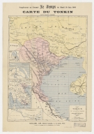
Barcode
3687800354357G
Title
Carte du Tonkin
Contributor
[Lassailly, Charles, fl. 18--, cartographer, Challamel, Pierre-Joseph, 1813-1892, editor, Dufour, F., fl. 18--, engraver, Dufrenoy, fl. 18--, printer]
Type
Printed
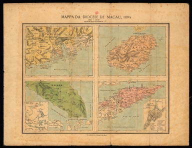
Barcode
3687800354437F
Title
Mapa da Diocese de Macau
Contributor
[Graça, Frei, author., Missionários de Macau, editor]
Type
Printed
Barcode
3687800354436E
Title
The Eastern part of East Indies stretching from Ceylon to Japan and New Holland
Contributor
Doncker, Hendrick, 1626-1699, cartographer
Type
Printed
Barcode
3687800354405A
Title
A new representation of China, once called the region of the Chinese, by Ludovicus Georgius.
Contributor
[Barbuda, Luís Jorge de, fl. 1575-1584, cartographer, Plantijnsche Drukkerij, printer]
Type
Printed
Barcode
3687800354439H
Title
Exacta et accurata delineatio cùm orarum maritimarum tùm etiam locorum terrestrium quae in regionibus China, Cauchinchina, Camboja sive Champa, Syao, Malacca, Arracan et Pegu, unà cum omnium vicinarum insularum descriptione ut sunt Samatra, Java utraq[ue], Timora, Molucca, Philippina, Luconia et de Lequeos dictae, nec non insulae Japan et Corea, reliquaeq[ue] omnes adjacentes, ubi etiam adnotavimus scopulos, brevia, omniaq[ue] vadosa loca, et siqua alia à quibus periculum navigantibus. Que madmodum singula hoc aevo à Lusitanis navium gubernatoribus comperta, indigetata, et in tabulas relata fuere. E quorum recentibus ac emendatis tabulis perquàm studiosè haec describi exprimiq[ue] curavimus, in eorum hominum co[m]modum quibus ista usui volupatiq[ue] esse consueueru[n]t = Waarachtige wtworpinghe oste afbeeldinge van alle die custen ende landen van China, Cauchinchina, Camboja, Sÿao, Malacca, Arracan ende Pegu, mitsgaders alle die biileggende eÿlanden groote ende cleinen, mit noch die clippen, riffen, sanden, droochten ende ondiepten, alles wt de alder correckste pas ende Lees-caarten getrocken die de Portugaloissche Stvÿrlviiden huiidendaechs gebruiicken.
Contributor
[Linschoten, Jan Huygen van, 1563-1611, cartographer, Langren, Arnold Florent van, 1580-1644, illustrator, Langren, Hendrik Floris van, ca.1574-1648, engraver, Claesz, Cornelis, ca. 1546-1609, printer]
Type
Printed
Barcode
3687800354447G
Title
A new representation of China, once called the region of the Chinese, by Ludovicus Georgius.
Contributor
[Barbuda, Luís Jorge de, fl. 1575-1584, cartographer, Cónegos Regrantes de Santo Agostinho. Mosteiro de São Vicente de Fora (Lisboa), former owner]
Type
Printed
Barcode
3687800301784C
Title
[Orien]
Contributor
Coronelli, Vincenzo, 1650-1718, cartographer
Type
Printed
Barcode
3687800354473F
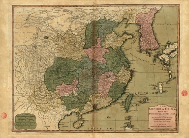
Title
The Empire of China with its principal divisions : drawn from the surveys made by the Jesuits, with improvements and additions from the maps of Mons.r D'Anville.
Contributor
[Anville, Jean Baptiste Bourguignon d', 1697-1782, bibliographic antecedent, Bowen, Maurice, fl. ca. 1780-1794, engraver, Whittle & Laurie, publisher]
Type
Printed
Barcode
36878003016649
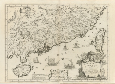
Title
Quantung, e Fokien : provincie della China
Contributor
Coronelli, Vincenzo, 1650-1718, cartographer
Type
Printed
Barcode
3687800317487J
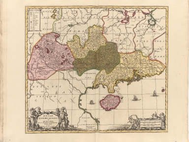
Title
Iunnan, Queicheu, Quangsi, et Quantung : provinciae Regni Sinensis, Praefecturae dictae, hoc est Meridiem inter et Occidentalis sitae
Contributor
[Valck, Gerard, 1626-1720, publisher, Schenk, Pieter, 1645-1715, publisher]
Type
Printed
Barcode
3687800285782L
Title
A new representation of China, once called the region of the Chinese, by Ludovicus Georgius
Contributor
[Barbuda, Luís Jorge de, fl. 1575-1584, cartographer, Plantin, Christophe, ca.1520-1589, printer, Norton, John, 15---1612, printer]
Type
Printed
Barcode
3687800317486I
Title
[Kaart van de kusten van Tonkin en Zuid-China]
Contributor
[Vinckeboons, Joan, 1617-1670, cartographer, Blaeu, Joan, 1596-1673, creator]
Type
Printed
Barcode
4687820501175
Title
A chart of the China Sea : inscribed to Mons.r d'Aprés de Mannevillette the ingenious author of the Neptune Oriental, as a tribute due to his labours for the benefit of navigation, and in acknowledgment of his many signal favours to A. Dalrymple.
Contributor
[Dalrymple, Alexander, 1737-1808, hydrographer, Henry, B., fl. 1770-1775, engraver, Whitchurch, William, fl. 18th century, engraver, Lane, Bartholomew, fl. 19th century, engraver, Après de Mannevillette, Jean-Baptiste-Nicolas-Denis d', 1707-1780, dedicatee]
Type
Printed
Barcode
36878003222312
Title
To the Society of Managing Owners of the Ships in the English East India Company's Service, This Chart of the China Sea, Including the Philippina Molluca and Banda Islands, Shewing al the same time all the Tracks into the Pacific Ocean, commonly known by the name of the Eastern Passage to China
Contributor
[Robertson, George, 1748-1788, cartographer, Harmer, Thomas, fl. 1784-1814, engraver]
Type
Printed
Barcode
36878003541013
Title
Exacta & accurata delineatio cùm orarum maritimarum tùm etiam locorum terrestrium quae in regionibus China, Cauchinchina, Camboja sive Champa, Syao, Malacca, Arracan & Pegu, unà cum omnium vicinarum insularum descriptione ut sunt Samatra, Java utraq[ue], Timora, Molucca, Philippina, Luconia & de Lequeos dictae, nec non insulae Japan & Corea, reliquaeq[ue] omnes adjacentes, ubi etiam adnotavimus scopulos, brevia, omniaq[ue] vadosa loca, & siqua alia à quibus periculum navigantibus. Que madmodum singula hoc aevo à Lusitanis navium gubernatoribus comperta, indigetata, & in tabulas relata fuere. E quorum recentibus ac emendatis tabulis perquàm studiosè haec describi exprimiq[ue] curavimus, in eorum hominum co[m]modum quibus ista usui volupatiq[ue] esse consueueru[n]t = Waarachtige wtworpinghe oste afbeeldinge van alle die custen ende landen van China, Cauchinchina, Camboja, Sÿao, Malacca, Arracan ende Pegu, mitsgaders alle die biileggende eÿlanden groote ende cleinen, mit noch die clippen, riffen, sanden, droochten ende ondiepten, alles wt de alder correckste pas ende Lees-caarten getrocken die de Portugaloissche Stvÿrlviiden huiidendaechs gebruiicken.
Exacta & accurata delineatio cùm orarum maritimarum tùm etiam locorum terrestrium quae in regionibus China, Cauchinchina, Camboja sive Champa, Syao, Malacca, Arracan & Pegu, unà cum omnium vicinarum insularum descriptione ut sunt Samatra, Java utraq[ue], Timora, Molucca, Philippina, Luconia & de Lequeos dictae, nec non insulae Japan & Corea, reliquaeq[ue] omnes adjacentes, ubi etiam adnotavimus scopulos, brevia, omniaq[ue] vadosa loca, & siqua alia à quibus periculum navigantibus. Que madmodum singula hoc aevo à Lusitanis navium gubernatoribus comperta, indigetata, & in tabulas relata fuere. E quorum recentibus ac emendatis tabulis perquàm studiosè haec describi exprimiq[ue] curavimus, in eorum hominum co[m]modum quibus ista usui volupatiq[ue] esse consueueru[n]t = Waarachtige wtworpinghe oste afbeeldinge van alle die custen ende landen van China, Cauchinchina, Camboja, Sÿao, Malacca, Arracan ende Pegu, mitsgaders alle die biileggende eÿlanden groote ende cleinen, mit noch die clippen, riffen, sanden, droochten ende ondiepten, alles wt de alder correckste pas ende Lees-caarten getrocken die de Portugaloissche Stvÿrlviiden huiidendaechs gebruiicken.
Contributor
Linschoten, Jan Huygen van, 1563-1611, cartographer
Type
Printed
1-41 of 41
|


![Carte generale de la Chine : dressée sur les cartes particulieres que l'Empereur Cang-hi a fait lever sur les lieux par les RR. PP. Jesuites mission[n]aires dans cet Empire](http://lunamap.must.edu.mo:80/MediaManager/srvr?mediafile=/Size2/MUST~2~2/54/GE+DD-2987+%287155+B%29.jpg)
![[Carta da China].](http://lunamap.must.edu.mo:80/MediaManager/srvr?mediafile=/Size2/MUST~2~2/325/3687800354427E%28bpe-gav4-pastaA-n9_0001%29.jpg)
![Exacta & accurata delineatio cùm orarum maritimarum tùm etiam locorum terrestrium quae in regionibus China, Cauchinchina, Camboja sive Champa, Syao, Malacca, Arracan & Pegu, unà cum omnium vicinarum insularum descriptione ut sunt Samatra, Java utraq[ue], Timora, Molucca, Philippina, Luconia & de Lequeos dictae, nec non insulae Japan & Corea, reliquaeq[ue] omnes adjacentes, ubi etiam adnotavimus scopulos, brevia, omniaq[ue] vadosa loca, & siqua alia à quibus periculum navigantibus. Que madmodum singula hoc aevo à Lusitanis navium gubernatoribus comperta, indigetata, & in tabulas relata fuere. E quorum recentibus ac emendatis tabulis perquàm studiosè haec describi exprimiq[ue] curavimus, in eorum hominum co[m]modum quibus ista usui volupatiq[ue] esse consueueru[n]t = Waarachtige wtworpinghe oste afbeeldinge van alle die custen ende landen van China, Cauchinchina, Camboja, Sÿao, Malacca, Arracan ende Pegu, mitsgaders alle die biileggende eÿlanden groote ende cleinen, mit noch die clippen, riffen, sanden, droochten ende ondiepten, alles wt de alder correckste pas ende Lees-caarten getrocken die de Portugaloissche Stvÿrlviiden huiidendaechs gebruiicken.](http://lunamap.must.edu.mo:80/MediaManager/srvr?mediafile=/Size2/MUST~2~2/325/3687800354406B%28bpe-gav2-pastaC-n54_0001%29.jpg)
![Exacta & accurata delineatio cum orarum maritimarum tum etiam locorum terrestrium quae in regionibus China, Cauchinchina, Camboja sive Champa, Syao, Malac[c]a, Arracan & Pegu, una cum omnium vicinarum insularum descriptione ut sunt Samatra, Java utraq[ue], Timora, Moluccae, Philippinae, Luconia & de Lequeos dictae, nec non insulae Japan & Corea, reliquaeq[ue] omnes adjacentes, ubi etiam adnotavimus scopulos, brevia, omniaq[ue] vadosa loca, & siquae alia a quibus periculum navigantibus. Que madmodum singula hoc aevo à Lusitanis navium gubernatoribus comperta, indigetata, & in tabulas relata fuere. E quorum recentibus ac emendatis tabulis perquàm studiosè haec describi exprimiq[ue] curavimus, in eorum hominum co[m]modum quibus ista usui volupatiq[ue] esse consueuerunnt = The trew description of all the coasts of China, Cauchinchina Camboya, Sӱao, malacca, Arracan, and Pegu, together with all the islands there abowts, both great and smale, with the cliffes, breaches, sands, droughts and shallowes, all perfectly drawne and examined with the most expert cardes of the Portingales pilots.](http://lunamap.must.edu.mo:80/MediaManager/srvr?mediafile=/Size2/MUST~2~2/325/3687800354409E%28bpe-gav2-pastaC-n55_0001%29.jpg)
![Exacta et accurata delineatio cùm orarum maritimarum tùm etiam locorum terrestrium quae in regionibus China, Cauchinchina, Camboja sive Champa, Syao, Malacca, Arracan et Pegu, unà cum omnium vicinarum insularum descriptione ut sunt Samatra, Java utraq[ue], Timora, Molucca, Philippina, Luconia et de Lequeos dictae, nec non insulae Japan et Corea, reliquaeq[ue] omnes adjacentes, ubi etiam adnotavimus scopulos, brevia, omniaq[ue] vadosa loca, et siqua alia à quibus periculum navigantibus. Que madmodum singula hoc aevo à Lusitanis navium gubernatoribus comperta, indigetata, et in tabulas relata fuere. E quorum recentibus ac emendatis tabulis perquàm studiosè haec describi exprimiq[ue] curavimus, in eorum hominum co[m]modum quibus ista usui volupatiq[ue] esse consueueru[n]t = Waarachtige wtworpinghe oste afbeeldinge van alle die custen ende landen van China, Cauchinchina, Camboja, Sÿao, Malacca, Arracan ende Pegu, mitsgaders alle die biileggende eÿlanden groote ende cleinen, mit noch die clippen, riffen, sanden, droochten ende ondiepten, alles wt de alder correckste pas ende Lees-caarten getrocken die de Portugaloissche Stvÿrlviiden huiidendaechs gebruiicken.](http://lunamap.must.edu.mo:80/MediaManager/srvr?mediafile=/Size2/MUST~2~2/346/3687800354439H%28cc-804-v_0001%29.jpg)
![[Orien]](http://lunamap.must.edu.mo:80/MediaManager/srvr?mediafile=/Size1/MUST~2~2/16/MA_17_96_2_pf_Orien.jpg)
![[Kaart van de kusten van Tonkin en Zuid-China]](http://lunamap.must.edu.mo:80/MediaManager/srvr?mediafile=/Size2/MUST~2~2/40/00000007.jpg)


![Exacta & accurata delineatio cùm orarum maritimarum tùm etiam locorum terrestrium quae in regionibus China, Cauchinchina, Camboja sive Champa, Syao, Malacca, Arracan & Pegu, unà cum omnium vicinarum insularum descriptione ut sunt Samatra, Java utraq[ue], Timora, Molucca, Philippina, Luconia & de Lequeos dictae, nec non insulae Japan & Corea, reliquaeq[ue] omnes adjacentes, ubi etiam adnotavimus scopulos, brevia, omniaq[ue] vadosa loca, & siqua alia à quibus periculum navigantibus. Que madmodum singula hoc aevo à Lusitanis navium gubernatoribus comperta, indigetata, & in tabulas relata fuere. E quorum recentibus ac emendatis tabulis perquàm studiosè haec describi exprimiq[ue] curavimus, in eorum hominum co[m]modum quibus ista usui volupatiq[ue] esse consueueru[n]t = Waarachtige wtworpinghe oste afbeeldinge van alle die custen ende landen van China, Cauchinchina, Camboja, Sÿao, Malacca, Arracan ende Pegu, mitsgaders alle die biileggende eÿlanden groote ende cleinen, mit noch die clippen, riffen, sanden, droochten ende ondiepten, alles wt de alder correckste pas ende Lees-caarten getrocken die de Portugaloissche Stvÿrlviiden huiidendaechs gebruiicken.
Exacta & accurata delineatio cùm orarum maritimarum tùm etiam locorum terrestrium quae in regionibus China, Cauchinchina, Camboja sive Champa, Syao, Malacca, Arracan & Pegu, unà cum omnium vicinarum insularum descriptione ut sunt Samatra, Java utraq[ue], Timora, Molucca, Philippina, Luconia & de Lequeos dictae, nec non insulae Japan & Corea, reliquaeq[ue] omnes adjacentes, ubi etiam adnotavimus scopulos, brevia, omniaq[ue] vadosa loca, & siqua alia à quibus periculum navigantibus. Que madmodum singula hoc aevo à Lusitanis navium gubernatoribus comperta, indigetata, & in tabulas relata fuere. E quorum recentibus ac emendatis tabulis perquàm studiosè haec describi exprimiq[ue] curavimus, in eorum hominum co[m]modum quibus ista usui volupatiq[ue] esse consueueru[n]t = Waarachtige wtworpinghe oste afbeeldinge van alle die custen ende landen van China, Cauchinchina, Camboja, Sÿao, Malacca, Arracan ende Pegu, mitsgaders alle die biileggende eÿlanden groote ende cleinen, mit noch die clippen, riffen, sanden, droochten ende ondiepten, alles wt de alder correckste pas ende Lees-caarten getrocken die de Portugaloissche Stvÿrlviiden huiidendaechs gebruiicken.](http://lunamap.must.edu.mo:80/MediaManager/srvr?mediafile=/Size2/MUST~2~2/354/36878003541013%28MAP+RM+4945%29.jpg)