|
Barcode
4687820501029
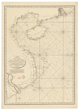
Title
[[Carte portugaise de la mer des Indes entre le Cap de Bonne Espérance et le Cap Comorin] ; [Carte portugaise de la mer qui comprend le Golfe du bengale, les côtes de la Chine et les îles du Japon, Philippines, de la Sonde et Moluques], [Carte portugaise de la mer des Indes entre le Cap de Bonne Espérance et le Cap Comorin]]
Contributor
Albernaz, João Teixeira, fl. 1602-1649, cartographer
Type
Printed
Barcode
4687820501007
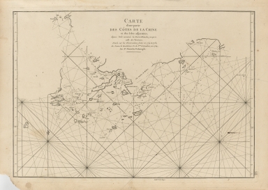
Title
[[Carte portugaise de la mer des Indes entre le Cap de Bonne Espérance et le Cap Comorin] ; [Carte portugaise de la mer qui comprend le Golfe du bengale, les côtes de la Chine et les îles du Japon, Philippines, de la Sonde et Moluques], [Carte portugaise de la mer qui comprend le Golfe du bengale, les côtes de la Chine et les îles du Japon, Philippines, de la Sonde et Moluques]]
Contributor
Albernaz, João Teixeira, fl. 1602-1649, cartographer
Type
Printed
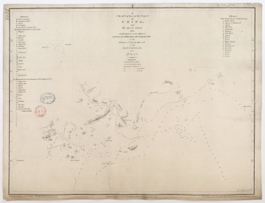
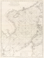
Barcode
4687820500041
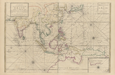
Title
[Chart of the China Sea]
Contributor
Norie, J. W. (John William), 1772-1843
Type
Printed
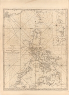
Barcode
4687820500800
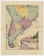
Title
[Map of the East Indies]
Contributor
Anonymous
Type
Printed
Barcode
4687820500491
Title
[World map by Battista Agnese]
Contributor
Agnese, Battista, active 16th century
Type
Printed
Barcode
4687820500015
Title
[World map]
Contributor
Cosa, Juan de la, -1510
Type
Printed
Barcode
4687820501177
Title
A chart of part of the coast of China, and the adjacent islands from Pedro Blanco to the Mizen : laid down from observations made in 1759 and 1760, in the Schooner Cuddalore, and in the Ship London, 1764
Contributor
[Dalrymple, Alexander, 1737-1808, hydrographer, publisher, Henry, B., fl. 1770-1775, engraver, Lerpinière, Daniel, 1745-1785, engraver, Whitchurch, William, fl. 18th century, engraver, Lane, Bartholomew, fl. 19th century, engraver]
Type
Printed
Barcode
4687820500218
Title
A chart of the China Sea : inscribed to Mons.r D'Aprés de Mannevillette the ingenious author of the Neptune Oriental, as a tribute due to his labours for the benefit of Navigation, and in acknowledgement of his many signal favours to Dalrymple.
Contributor
[Dalrymple, Alexander, 1737-1808, hydrographer, Demonville, Antoine Guénard, ca. 1733-1797, printer, Malassis, Romain-Nicolas, 1737-1813, printer, Après de Mannevillette, Jean-Baptiste-Nicolas-Denis d', 1707-1780, dedicatee]
Type
Printed
Barcode
4687820501175
Title
A chart of the China Sea : inscribed to Mons.r d'Aprés de Mannevillette the ingenious author of the Neptune Oriental, as a tribute due to his labours for the benefit of navigation, and in acknowledgment of his many signal favours to A. Dalrymple.
Contributor
[Dalrymple, Alexander, 1737-1808, hydrographer, Henry, B., fl. 1770-1775, engraver, Whitchurch, William, fl. 18th century, engraver, Lane, Bartholomew, fl. 19th century, engraver, Après de Mannevillette, Jean-Baptiste-Nicolas-Denis d', 1707-1780, dedicatee]
Type
Printed
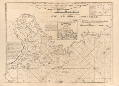
Barcode
687800354127B
Title
A chart of the China Sea from the Island of Sanciam to Pedra Branca with the course of the River Tigris from Canton to Macao
Contributor
[Après de Mannevillette, Jean-Baptiste-Nicolas-Denis d', 1707-1780, cartographer, Larkins, John Pascal, 17---1794, author, bibliographic antecedent, Anson, George Anson, baron, 1697-1762, author, Huddart, Joseph, 1741-1816, bibliographic antecedent]
Type
Printed
Barcode
4687820500260
Title
A chart of the China Sea, and Philippine Islands with the Archipelagos of Felicia and Soloo : shewing the whole tract comprized, between Canton and Balambangan, with the soundings, shoals, rocks, & ca.
Contributor
Whittle & Laurie, publisher
Type
Printed
Barcode
4687820500782
Title
A chart of the East India Islands with the coasts of the continent from Caliminera Point to Amoye in China
Contributor
Anonymous
Type
Printed
Barcode
4687820500785
Title
A chart of the eastermost part of the East Indies from the island Zeloan to Amoy in China : with the adjacent islands adjusted according to the most accurate astronomical observations
Contributor
Seller, John, active 1658-1698
Type
Printed
Barcode
4687820500255
Title
A chart of the south coast of Hay-nan, from Tinhosa to Guichou
Contributor
[Haldane, John, captain, fl. 177-, cartographer, Laurie & Whittle, publisher]
Type
Printed
Barcode
4687820500256
Title
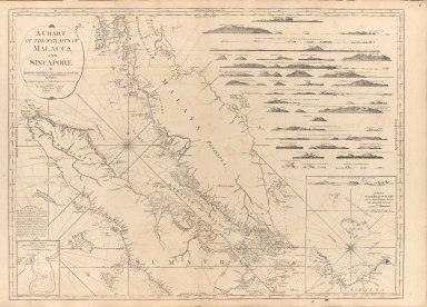
A chart of the Straits of Malacca and Sincapore
Contributor
Thomas, Jeffrey
Type
Printed
Barcode
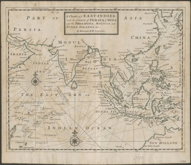
4687820500788
Title
A chart of ye East-Indies with the coast of Persia, China also the Philipina, Moluca and Sunda Islands, &c.
Contributor
Moll, Herman, -1732
Type
Printed
Barcode
4687820500783
Title
A general chart of the China Sea : drawn from the journals of the European navigators, particularly from those collected by Capt. Hayter
Contributor
Anonymous
Type
Printed
Barcode
4687820500710
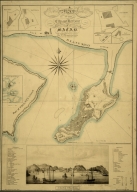
Title
A map of the city and harbour of Macao
Contributor
Bramston, William, 17---18--, author
Type
Printed
Barcode
4687820501178
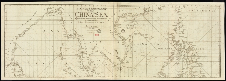
Title
A new and correct chart of the China Sea
Contributor
[Moore, John Hamilton, 1738-1807, cartographer, Blake, T. J., fl. 1785-1785, engraver]
Type
Printed
Barcode
3687800317471C
Title
A new and correct chart of the coast of China : from latitude 12° north to 26° including Formosa, Hayman and the Philippine Islands.
Contributor
W. and J. Mount, T. and T. Page, 1747-1763, publisher, bookseller
Type
Printed
Barcode
3687800354267G
Title
A new chart of the China Sea, with its several entrances : drawn from a great number of draughts, journals, and other National documents, regulated by astronomical observation
Contributor
[Laurie & Whittle, author, publisher, Larkins, John Pascal, 17---1794, cartographer, Rees, Captain, cartographer]
Type
Printed
Barcode
4687820500336
Title
A new chart of the China Sea, with its several entrances : drawn from a great number of draughts, journals, and other National documents, regulated by astronomical observations
Contributor
[Laurie & Whittle, author, publisher, Larkins, John Pascal, 17---1794, cartographer, Rees, Captain, cartographer]
Type
Printed
Barcode
4687820500440
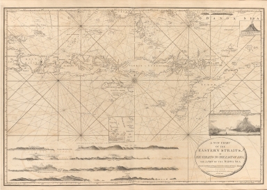
Title
A new chart of the Eastern Straits or the straits to the east of Java with a part of the Banda Sea
Contributor
Williams, Robert
Type
Printed
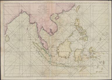
Barcode
3687800301756B
Title
A new chart of the oriental seas and islands with the coasts of the continent from the Isle of Ceylon to Amoye in China
Contributor
[Après de Mannevillette, Jean-Baptiste-Nicolas-Denis d', 1707-1780, cartographer, Laurie & Whittle, publisher]
Type
Printed
Barcode
4687820501102
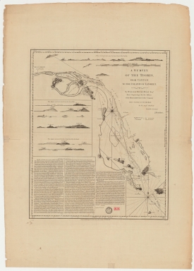
Title
A survey of the Tigris from Canton to the island of Lankeet
Contributor
Huddart, Joseph, 1741-1816
Type
Printed
Barcode
4687820500386
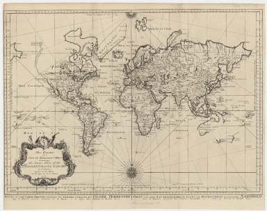
Title
An essay of a new and compact map containing the known parts of the terrestrial globe = Essay d’une carte reduite contenant les parties connues du globe terrestre = Proef van eene aan-eengeschakelde kaart der bekende-deelen des gantschen aardbols
Contributor
[Bellin, Jacques Nicolas, 1703-1772, Hondt, Pieter de, Schley, Jacobus van der, 1715-1779]
Type
Printed
Barcode
4687820500011
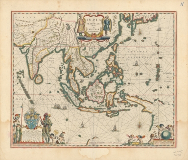
Title
Blaeu map of Southeast Asia and the surrounding areas
Contributor
Blaeu, Willem Janszoon, 1571-1638
Type
Printed
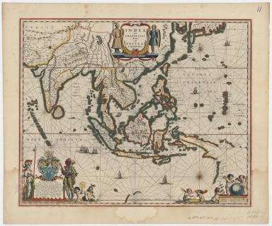
Barcode
4687820500534
Title
Blaeu map of Southeast Asia and the surrounding areas
Contributor
Blaeu, Willem Janszoon, 1571-1638
Type
Printed
Barcode
4687820500774
Title
Carta hydrografica da Colonia de Macau
Contributor
[Macau. Obras dos Portos, Braga, José Maria, 1897-1988, former owner]
Type
Printed
Barcode
4687820500622
Title
Carta Universal en que se contiene todo lo que del mundo se ha descubierto fasta agora / hizola Diego Ribero cosmographo de Su magestad, Anõ de 1529. e[n] Sevilla. La qual se devide en dos partes conforme ala capitulaçion que hizieron los catholicos Reyes de españa [y] el Rey don Juan de portogual en Tordesillas, Anõ de 1494.
Contributor
[Ribeiro, Diogo, fl. 1519-1533, cartographer, Griggs, William, 1832-1911]
Type
Printed
Barcode
4687820501174
Title
Carte d'une partie de la mer de Chine
Contributor
Rosili Mesros, François Etienne de, 1748-1832, bibliographic antecedent
Type
Printed
Barcode
4687820500211
Title
Carte d'une partie des côtes de la Chine et des Isles adjacentes : depuis l'Isle nommée la Pierre Blanche, jusqu'a celle de l'Artimon
Contributor
Dalrymple, Alexander, 1737-1808
Type
Printed
Barcode
4687820500039
Title
Carte de l'entrée de la riviere de Canton : dressée sur les observations les plus récentes = Kaart van 't inkoomen der riviere van Kanton
Contributor
[Bellin, Jacques Nicolas, 1703-1772, Hondt, Pieter de, Schley, Jacobus van der, 1715-1779]
Type
Printed
Barcode
4687820500010
Title
Carte de l'entrée de la riviere de Canton dans la Chine
Contributor
Bellin, Jacques-Nicolas, 1703-1772, cartographer
Type
Printed
Barcode
4687820500203
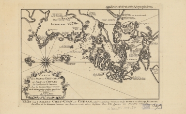
Title
Carte de l'isle de Cheu-Chan, ou l'isle de Chusan, de la province de Che-kiang : avec les costes et isles voisines = Kaart van 't Eiland Cheu-Chan, of Chusan, onder 't Landschap Che-Kiang, met kusten en nabuurige Eilanden
Contributor
[Bellin, Jacques Nicolas, 1703-1772, Hondt, Pieter de, Schley, Jacobus van der, 1715-1779]
Type
Printed
Barcode
4687820500207
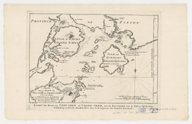
Title
Carte de la baye de Chin-Cheouw ou Chang-Cheouw avec les isles d’Emowi et de Quemowi : dressée sur les divers manuscrits = Kaart der baal van Chin-Chew, of Chang-Chew, met de eilanden va A-mwi en Que-mwi
Contributor
[Bellin, Jacques Nicolas, 1703-1772, Hondt, Pieter de, Schley, Jacobus van der, 1715-1779]
Type
Printed
Barcode
4687820500200
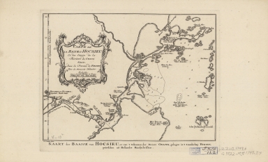
Title
Carte de la baye d’Hocsieu et des entrées de la riviere de Chang situées dans la province de Fokyen : tirées de manuscrits hollandois = Kaart der baaije van Hocsieu, en van ’t inkoomen der riviere Chang, gelegen in’t lanschap Fokien
Contributor
[Bellin, Jacques Nicolas, 1703-1772, Hondt, Pieter de, Schley, Jacobus van der, 1715-1779]
Type
Printed
Barcode
4687820500380
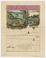
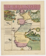
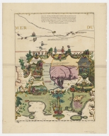
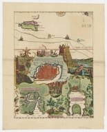
Title
Carte de la Mer du Sud et de la Mer du Nord : ou se trouve les costes d'Amerique, d'Asie, d'Europe et d'Afrique situées sur ces mers. Part 1
Contributor
Fer, Nicolas de, 1646-1720
Type
Printed
Barcode
4687820500357
Title
Carte de la Mer du Sud et de la Mer du Nord : ou se trouve les costes d'Amerique, d'Asie, d'Europe et d'Afrique situées sur ces mers. Part 10
Contributor
Fer, Nicolas de, 1646-1720
Type
Printed
Barcode
4687820500378
Title
Carte de la Mer du Sud et de la Mer du Nord : ou se trouve les costes d'Amerique, d'Asie, d'Europe et d'Afrique situées sur ces mers. Part 2
Contributor
Fer, Nicolas de, 1646-1720
Type
Printed
Barcode
4687820500356
Title
Carte de la Mer du Sud et de la Mer du Nord : ou se trouve les costes d'Amerique, d'Asie, d'Europe et d'Afrique situées sur ces mers. Part 3
Contributor
Fer, Nicolas de, 1646-1720
Type
Printed
Barcode
4687820500381
Title
Carte de la Mer du Sud et de la Mer du Nord : ou se trouve les costes d'Amerique, d'Asie, d'Europe et d'Afrique situées sur ces mers. Part 4
Contributor
Fer, Nicolas de, 1646-1720
Type
Printed
Barcode
4687820500353
Title
Carte de la Mer du Sud et de la Mer du Nord : ou se trouve les costes d'Amerique, d'Asie, d'Europe et d'Afrique situées sur ces mers. Part 5
Contributor
Fer, Nicolas de, 1646-1720
Type
Printed
Barcode
4687820500379
Title
Carte de la Mer du Sud et de la Mer du Nord : ou se trouve les costes d'Amerique, d'Asie, d'Europe et d'Afrique situées sur ces mers. Part 6
Contributor
Fer, Nicolas de, 1646-1720
Type
Printed
Barcode
4687820500355
Title
Carte de la Mer du Sud et de la Mer du Nord : ou se trouve les costes d'Amerique, d'Asie, d'Europe et d'Afrique situées sur ces mers. Part 7
Contributor
Fer, Nicolas de, 1646-1720
Type
Printed
Barcode
4687820500352
Title
Carte de la Mer du Sud et de la Mer du Nord : ou se trouve les costes d'Amerique, d'Asie, d'Europe et d'Afrique situées sur ces mers. Part 8
Contributor
Fer, Nicolas de, 1646-1720
Type
Printed
Barcode
4687820500354
Title
Carte de la Mer du Sud et de la Mer du Nord : ou se trouve les costes d'Amerique, d'Asie, d'Europe et d'Afrique situées sur ces mers. Part 9
Contributor
Fer, Nicolas de, 1646-1720
Type
Printed
Barcode
4687820500350
Title
Carte des costes de l'Asie sur l'Ocean : contenant les bancs isles et costes & c, levee sur les memoires les plus nouveau
Contributor
Mortier, Pierre, 1661-1711
Type
Printed
Barcode
4687820500131
Title
Carte des côtes de l'Amérique et de l'Asie : depuis la Californie jusqu'à Macao
Contributor
La Pérouse, Jean-François de Galaup, comte de, 1741-1788
Type
Printed
Barcode
4687820500212
Title
Carte des découvertes faites en 1787 dans les mers de Chine et de Tartarie : par les frégates françaises la Boussole et l'Astrolabe, depuis leur départ de Manille jusqu'à leur arrivée au Kamtschatka
Contributor
La Pérouse, Jean-François de Galaup, comte de, 1741-1788
Type
Printed
|
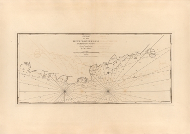
![[[Carte portugaise de la mer des Indes entre le Cap de Bonne Espérance et le Cap Comorin] ; [Carte portugaise de la mer qui comprend le Golfe du bengale, les côtes de la Chine et les îles du Japon, Philippines, de la Sonde et Moluques], [Carte portugaise de la mer des Indes entre le Cap de Bonne Espérance et le Cap Comorin]]](http://lunamap.must.edu.mo:80/MediaManager/srvr?mediafile=/Size1/MUST~2~2/54/GE+DD-2987+Carte+portugaise+de+la+mer+des+Indes+-1+.jpg)
![[[Carte portugaise de la mer des Indes entre le Cap de Bonne Espérance et le Cap Comorin] ; [Carte portugaise de la mer qui comprend le Golfe du bengale, les côtes de la Chine et les îles du Japon, Philippines, de la Sonde et Moluques], [Carte portugaise de la mer qui comprend le Golfe du bengale, les côtes de la Chine et les îles du Japon, Philippines, de la Sonde et Moluques]]](http://lunamap.must.edu.mo:80/MediaManager/srvr?mediafile=/Size2/MUST~2~2/54/GE+DD-2987+Carte+portugaise+de+la+mer+des+Indes+-2+.jpg)
![[Chart of the China Sea]](http://lunamap.must.edu.mo:80/MediaManager/srvr?mediafile=/Size2/MUST~2~2/25/G7822_P4_1840_N6.jpg)
![[Map of the East Indies]](http://lunamap.must.edu.mo:80/MediaManager/srvr?mediafile=/Size2/MUST~2~2/41/RBRS+N+910.91+T418-69.jpg)
![[World map by Battista Agnese]](http://lunamap.must.edu.mo:80/MediaManager/srvr?mediafile=/Size2/MUST~2~2/41/G1026_R33_1871_17_F_02%C3%A5%C2%89%C2%AF%C3%A6%C2%9C%C2%AC.jpg)
![[World map]](http://lunamap.must.edu.mo:80/MediaManager/srvr?mediafile=/Size1/MUST~2~2/30/G3200_1500_C6_1900.jpg)


![Carta Universal en que se contiene todo lo que del mundo se ha descubierto fasta agora / hizola Diego Ribero cosmographo de Su magestad, Anõ de 1529. e[n] Sevilla. La qual se devide en dos partes conforme ala capitulaçion que hizieron los catholicos Reyes de españa [y] el Rey don Juan de portogual en Tordesillas, Anõ de 1494.](http://lunamap.must.edu.mo:80/MediaManager/srvr?mediafile=/Size3/MUST~2~2/30/G3200+1529+.R5+1887+MLC.jpg)