|
REFINE
Browse All : General Maps and Printed and Atlas
1-18 of 18
Barcode
3687800354419F
Title
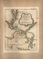
Carte de l'Isle Formose aux costes de la Chine
Contributor
Bellin, Jacques-Nicolas, 1703-1772, cartographer
Type
Printed
Barcode
3687800354423A
Title
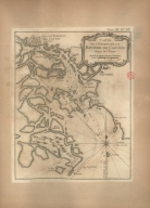
Carte de la Baye d'Hocsieu et des entrées de la riviere de Chang, dans la Province de Fokyen, en Chine
Contributor
Bellin, Jacques-Nicolas, 1703-1772, cartographer
Type
Printed
Barcode
36878003544218
Title
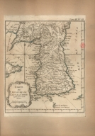
Carte du royaume de Kau-li ou Corée : copiée sur la Carte Angloise
Contributor
Bellin, Jacques-Nicolas, 1703-1772, cartographer
Type
Printed
Barcode
3687800354416C
Title
Carte de l'entrée de la riviere de Canton dans la Chine
Contributor
Bellin, Jacques-Nicolas, 1703-1772, cartographer
Type
Printed
Barcode
3687800354425C
Title
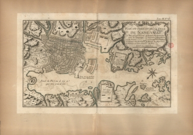
Plan du port et de la ville de Nangasaki
Contributor
Bellin, Jacques-Nicolas, 1703-1772, cartographer
Type
Printed
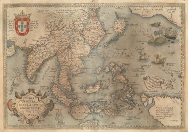
Barcode
3687800354409E
Title
Exacta & accurata delineatio cum orarum maritimarum tum etiam locorum terrestrium quae in regionibus China, Cauchinchina, Camboja sive Champa, Syao, Malac[c]a, Arracan & Pegu, una cum omnium vicinarum insularum descriptione ut sunt Samatra, Java utraq[ue], Timora, Moluccae, Philippinae, Luconia & de Lequeos dictae, nec non insulae Japan & Corea, reliquaeq[ue] omnes adjacentes, ubi etiam adnotavimus scopulos, brevia, omniaq[ue] vadosa loca, & siquae alia a quibus periculum navigantibus. Que madmodum singula hoc aevo à Lusitanis navium gubernatoribus comperta, indigetata, & in tabulas relata fuere. E quorum recentibus ac emendatis tabulis perquàm studiosè haec describi exprimiq[ue] curavimus, in eorum hominum co[m]modum quibus ista usui volupatiq[ue] esse consueuerunnt = The trew description of all the coasts of China, Cauchinchina Camboya, Sӱao, malacca, Arracan, and Pegu, together with all the islands there abowts, both great and smale, with the cliffes, breaches, sands, droughts and shallowes, all perfectly drawne and examined with the most expert cardes of the Portingales pilots.
Contributor
[Linschoten, Jan Huygen van, 1563-1611, cartographer, Beckit, Robert, engraver, Wolfe, John, ca. 1547-1601, printer]
Type
Printed
Barcode
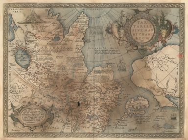
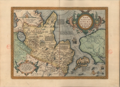
36878003544117
Title
Map of Tartaria or the kingdom of the great Cham.
Contributor
[Ortelius, Abraham, 1527-1598, author, Plantijnsche Drukkerij, printer]
Type
Printed
Barcode
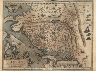
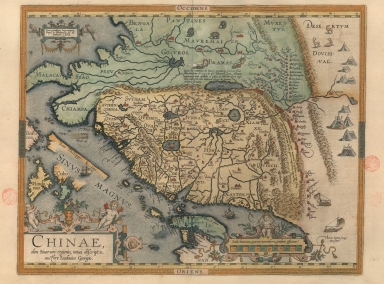
3687800354405A
Title
A new representation of China, once called the region of the Chinese, by Ludovicus Georgius.
Contributor
[Barbuda, Luís Jorge de, fl. 1575-1584, cartographer, Plantijnsche Drukkerij, printer]
Type
Printed
Barcode
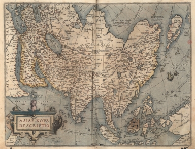
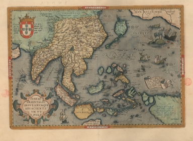
3687800354407C
Title
A map of the East Indies and surrounding islands
Contributor
[Ortelius, Abraham, 1527-1598, author, Plantijnsche Drukkerij, printer]
Type
Printed
Barcode
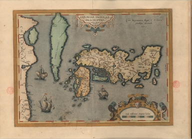
3687800354408D
Title
A representation of the island of Japan by Luis Teixeira
Contributor
Teixeira, Luís, 1564-1604, cartographer
Type
Printed
Barcode
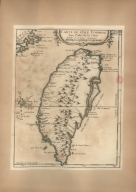
3687800354439H
Title
Exacta et accurata delineatio cùm orarum maritimarum tùm etiam locorum terrestrium quae in regionibus China, Cauchinchina, Camboja sive Champa, Syao, Malacca, Arracan et Pegu, unà cum omnium vicinarum insularum descriptione ut sunt Samatra, Java utraq[ue], Timora, Molucca, Philippina, Luconia et de Lequeos dictae, nec non insulae Japan et Corea, reliquaeq[ue] omnes adjacentes, ubi etiam adnotavimus scopulos, brevia, omniaq[ue] vadosa loca, et siqua alia à quibus periculum navigantibus. Que madmodum singula hoc aevo à Lusitanis navium gubernatoribus comperta, indigetata, et in tabulas relata fuere. E quorum recentibus ac emendatis tabulis perquàm studiosè haec describi exprimiq[ue] curavimus, in eorum hominum co[m]modum quibus ista usui volupatiq[ue] esse consueueru[n]t = Waarachtige wtworpinghe oste afbeeldinge van alle die custen ende landen van China, Cauchinchina, Camboja, Sÿao, Malacca, Arracan ende Pegu, mitsgaders alle die biileggende eÿlanden groote ende cleinen, mit noch die clippen, riffen, sanden, droochten ende ondiepten, alles wt de alder correckste pas ende Lees-caarten getrocken die de Portugaloissche Stvÿrlviiden huiidendaechs gebruiicken.
Contributor
[Linschoten, Jan Huygen van, 1563-1611, cartographer, Langren, Arnold Florent van, 1580-1644, illustrator, Langren, Hendrik Floris van, ca.1574-1648, engraver, Claesz, Cornelis, ca. 1546-1609, printer]
Type
Printed
Barcode
3687800354446F
Title
Map of Tartaria or the kingdom of the great Cham
Contributor
[Ortelius, Abraham, 1527-1598, author, Cónegos Regrantes de Santo Agostinho. Mosteiro de São Vicente de Fora (Lisboa), former owner]
Type
Printed
Barcode
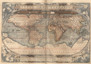
3687800354444D
Title
Image of the countries of the world.
Contributor
[Ortelius, Abraham, 1527-1598, author, Hogenberg, Frans, ca. 1539-1590, engraver, Cónegos Regrantes de Santo Agostinho. Mosteiro de São Vicente de Fora (Lisboa), former owner]
Type
Printed
Barcode
3687800354447G
Title
A new representation of China, once called the region of the Chinese, by Ludovicus Georgius.
Contributor
[Barbuda, Luís Jorge de, fl. 1575-1584, cartographer, Cónegos Regrantes de Santo Agostinho. Mosteiro de São Vicente de Fora (Lisboa), former owner]
Type
Printed
Barcode
3687800354448H
Title
A New Depiction of Asia.
Contributor
[Ortelius, Abraham, 1527-1598, author, Cónegos Regrantes de Santo Agostinho. Mosteiro de São Vicente de Fora (Lisboa), former owner]
Type
Printed
Barcode
3687800354449I
Title
A map of the East Indies and surrounding islands.
Contributor
[Ortelius, Abraham, 1527-1598, author, Cónegos Regrantes de Santo Agostinho. Mosteiro de São Vicente de Fora (Lisboa), former owner]
Type
Printed
Barcode
3687800354451B
Title
Image of the countries of the world.
Contributor
[Ortelius, Abraham, 1527-1598, author, Hogenberg, Frans, ca. 1539-1590, engraver]
Type
Printed
1-18 of 18
|
![Exacta & accurata delineatio cum orarum maritimarum tum etiam locorum terrestrium quae in regionibus China, Cauchinchina, Camboja sive Champa, Syao, Malac[c]a, Arracan & Pegu, una cum omnium vicinarum insularum descriptione ut sunt Samatra, Java utraq[ue], Timora, Moluccae, Philippinae, Luconia & de Lequeos dictae, nec non insulae Japan & Corea, reliquaeq[ue] omnes adjacentes, ubi etiam adnotavimus scopulos, brevia, omniaq[ue] vadosa loca, & siquae alia a quibus periculum navigantibus. Que madmodum singula hoc aevo à Lusitanis navium gubernatoribus comperta, indigetata, & in tabulas relata fuere. E quorum recentibus ac emendatis tabulis perquàm studiosè haec describi exprimiq[ue] curavimus, in eorum hominum co[m]modum quibus ista usui volupatiq[ue] esse consueuerunnt = The trew description of all the coasts of China, Cauchinchina Camboya, Sӱao, malacca, Arracan, and Pegu, together with all the islands there abowts, both great and smale, with the cliffes, breaches, sands, droughts and shallowes, all perfectly drawne and examined with the most expert cardes of the Portingales pilots.](http://lunamap.must.edu.mo:80/MediaManager/srvr?mediafile=/Size2/MUST~2~2/325/3687800354409E%28bpe-gav2-pastaC-n55_0001%29.jpg)
![Exacta et accurata delineatio cùm orarum maritimarum tùm etiam locorum terrestrium quae in regionibus China, Cauchinchina, Camboja sive Champa, Syao, Malacca, Arracan et Pegu, unà cum omnium vicinarum insularum descriptione ut sunt Samatra, Java utraq[ue], Timora, Molucca, Philippina, Luconia et de Lequeos dictae, nec non insulae Japan et Corea, reliquaeq[ue] omnes adjacentes, ubi etiam adnotavimus scopulos, brevia, omniaq[ue] vadosa loca, et siqua alia à quibus periculum navigantibus. Que madmodum singula hoc aevo à Lusitanis navium gubernatoribus comperta, indigetata, et in tabulas relata fuere. E quorum recentibus ac emendatis tabulis perquàm studiosè haec describi exprimiq[ue] curavimus, in eorum hominum co[m]modum quibus ista usui volupatiq[ue] esse consueueru[n]t = Waarachtige wtworpinghe oste afbeeldinge van alle die custen ende landen van China, Cauchinchina, Camboja, Sÿao, Malacca, Arracan ende Pegu, mitsgaders alle die biileggende eÿlanden groote ende cleinen, mit noch die clippen, riffen, sanden, droochten ende ondiepten, alles wt de alder correckste pas ende Lees-caarten getrocken die de Portugaloissche Stvÿrlviiden huiidendaechs gebruiicken.](http://lunamap.must.edu.mo:80/MediaManager/srvr?mediafile=/Size2/MUST~2~2/346/3687800354439H%28cc-804-v_0001%29.jpg)