|
REFINE
Browse All : China -- Maps and Sea Charts
1-39 of 39
Barcode
4687820501061
Title
Universa ac navigabilis to / tius terrarum orbis descrip /tio, cum omnibus por /tubus, Ynsulis, fluviis, Promō /toriis, stationibus, Angulis, ac /sinibus, adicta certissima, tum / Latitudinis, tum longitudinis graduū /dimensione, ut nihil reliquum sit, quod ad / Yustum cosmographiae tractatum spectare videatur / Andreas Homo /cosmographus /luzitanus me / faciebat Antver /piae anno milles /simo quingentessi /mo quinquagessimo, nono
Contributor
[Homem, Andreas, Faleiro, Francisco, active 1535]
Type
Manuscripts
Barcode
4687820501066
Title
Carte hollandaise de la Mer de Chine
Contributor
Anonymous
Type
Manuscripts
Barcode
4687820501087
Title
Carte des côtes de Siam et partie de celles de la Chine Depuis le port et l'Ile de Quemoy jusques à la pointe de la presqu'isle de Malaca avec les Isles de Formose, les Philippines, celles de la Sonde avec partie de celles des Moluques
Contributor
Lavigne, 16..-17..
Type
Manuscripts
Barcode
4687820501103
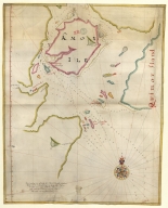
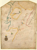
Title
Island of Amoy
Contributor
Thornton, John
Type
Manuscripts
Barcode
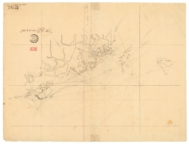
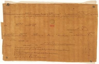
4687820500989
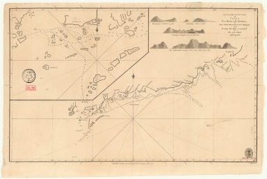
Title
[Plan of Mirs Bay on the coast of China, Chart of the island Lamock, Lamon, Plan of Ping Hai Bay]
Contributor
Murphy, Edward
Type
Manuscripts
Barcode
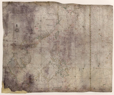
4687820501012
Title
[Indian Ocean from the Cape of Good Hope to Banda and from the Black Sea to Japan, Arabia, Persia, India, Indo-china and Insulinde, South China, Japan]
Contributor
Angelus, author
Type
Manuscripts
Barcode
4687820501260
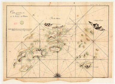
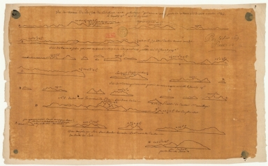
Title
[Vues de cotes des mers de Chine]. 1.er
Contributor
Surville, Jean-François de, 1717-1770, author
Type
Manuscripts
Barcode
4687820501261
Title
[Vues de cotes des mers de Chine]. 2.e
Contributor
Surville, Jean-François de, 1717-1770, author
Type
Manuscripts
Barcode
4687820501262
Title
[Vues de cotes des mers de Chine]. 3.º
Contributor
Surville, Jean-François de, 1717-1770, author
Type
Manuscripts
Barcode
4687820501267
Title
[Vues de cotes des mers de Chine]. 5.e
Contributor
Surville, Jean-François de, 1717-1770, author
Type
Manuscripts
Barcode
4687820501263
Title
[Vues de cotes des mers de Chine]. 4.e
Contributor
Surville, Jean-François de, 1717-1770, author
Type
Manuscripts
Barcode
4687820501266
Title
[Vues de cotes des mers de Chine]. 7.e
Contributor
Surville, Jean-François de, 1717-1770, author
Type
Manuscripts
Barcode
4687820501264
Title
[Vues de cotes des mers de Chine]. 8.e
Contributor
Surville, Jean-François de, 1717-1770, author
Type
Manuscripts
Barcode
4687820501265
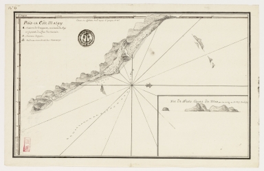
Title
Païs et côte Malay
Contributor
Surville, Jean-François de, 1717-1770, cartographer
Type
Manuscripts
Barcode
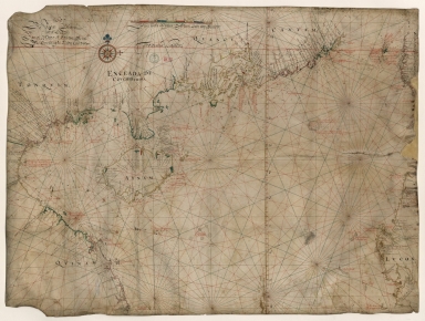
4687820501174
Title
Carte d'une partie de la mer de Chine
Contributor
Rosili Mesros, François Etienne de, 1748-1832, bibliographic antecedent
Type
Printed
Barcode
3687800354286H
Title
[Carte d'une partie de la mer de Chine]
Type
Manuscripts
Barcode
3687800354287I
Title
To the Honorable the Court of Directors of the United Company of Merchants of England trading to the East Indies, this Chart of the China Seas
Contributor
[Heather, William, 1764-1812, hydrographer, Stephenson, John,, fl. 1791-1817, engraver, Norie, John William, 1772-1843, illustrator, Heather and Williams, publisher]
Type
Printed
Barcode
4687820501015
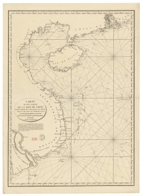
Title
Carte pour la navigation des mers entre les cotes de Chine et du Blanc le Paracel et de celles du Golfe de Cochinchine : dressée sur une carte MS.te a M.r Bouvet qui contenoit depuis le 2.e deg. jusq.' 24.e dont cette 1.ere feuille ne comprend que du 24.e au 13.e degré.
Contributor
Bouvet, 16---17--, bibliographic antecedent
Type
Manuscripts
Barcode
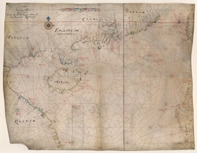
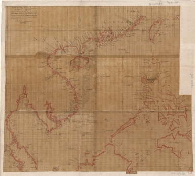
4687820501077
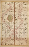
Title
Carte generale de la Chine : dressée sur les cartes particulieres que l'Empereur Cang-hi a fait lever sur les lieux par les RR. PP. Jesuites mission[n]aires dans cet Empire
Contributor
[Anville, Jean Baptiste Bourguignon d', 1697-1782, cartographer, Gravelot, Hubert-François, 1699-1773, illustrator, engraver, Delahaye, Jean Baptiste, fl. 1721-1723, engraver]
Type
Manuscripts
Barcode
4687820501093
Title
Neat outline of the Beijing river in China located in the Indian Sea
Type
Manuscripts
Barcode
4687820501008
Title
Carte des Isles de Lieou-Kieou dont le roi est tributaire de la Chine : Cette Carte est l'ouvrage du P. Gaubil, envoyée à M. L'Abbé Sallier qui l'a reçue en 1752, et me la communiquée aussitôt.
Contributor
[Gaubil, Antoine, 1689-1759, bibliographic antecedent, Sallier, Claude, 1685-1761, correspondent]
Type
Manuscripts
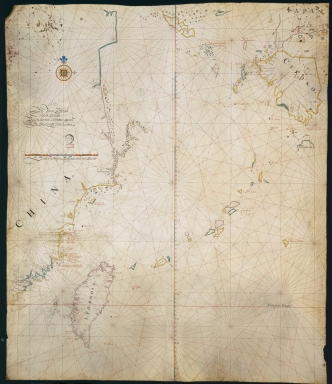
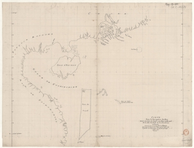
Barcode
4687820501013
Title
[Observations publiées en 1646-1648 par Robert Dudley, Atlantique, Méditerranée, Océan Indien, Mer de Chine]
Contributor
[Delisle, Guillaume, 1675-1726, cartographer, Dudley, Robert, Sir, 1574-1649, bibliographic antecedent]
Type
Manuscripts
Barcode
3687800354504A
Title
Chart of the south coast of China from Macao to The Brothers
Contributor
[Inverarity, David, 17---18--, cartographer, Dalrymple, Alexander, 1737-1808, editor, publisher, Harmer, Thomas, fl. 1784-1814, engraver]
Type
Printed
Barcode
3687800354506C
Title
Map of the China Sea
Contributor
Blaeu, Joan, 1596-1673, cartographer
Type
Manuscripts
Barcode
3687800354509F
Title
Map of the coasts of China and neighboring islands with some additions
Contributor
Anville, Jean Baptiste Bourguignon d', 1697-1782, cartographer
Type
Printed
Barcode
3687800354508E
Title
Map of the coasts of China and neighboring islands with some additions
Contributor
Anville, Jean Baptiste Bourguignon d', 1697-1782, cartographer
Type
Manuscripts
Barcode
3687800317478J
Title
Dutch nautical chart of the 18th century, including the coasts of Annam, Tonkin, China, Hainan Island and part of Luzon
Contributor
Saffroy, Amand, 1844-1905, former owner
Type
Manuscripts
Barcode
3687800354255D
Title
Map of the South China Sea
Contributor
Blaeu, Joan, 1596-1673, cartographer
Type
Manuscripts
Barcode
3687800317483F
Title
Dutch Chart of the China Sea
Type
Manuscripts
Barcode
3687800354228D
Title
Gulf of Tonkin
Contributor
Blaeu, Joan, 1596-1673, cartographer
Type
Manuscripts
Barcode
3687800354566I
Title
Gulf of Tonkin
Contributor
Blaeu, Joan, 1650-1712, cartographer
Type
Manuscripts
Barcode
3687800354560C
Title
China Sea
Contributor
Blaeu, Joan, 1596-1673, cartographer
Type
Manuscripts
Barcode
3687800354570D
Title
English chart of the island of Amoy
Contributor
Thornton, John, 1641-1708, cartographer
Type
Manuscripts
Barcode
4687820501175
Title
A chart of the China Sea : inscribed to Mons.r d'Aprés de Mannevillette the ingenious author of the Neptune Oriental, as a tribute due to his labours for the benefit of navigation, and in acknowledgment of his many signal favours to A. Dalrymple.
Contributor
[Dalrymple, Alexander, 1737-1808, hydrographer, Henry, B., fl. 1770-1775, engraver, Whitchurch, William, fl. 18th century, engraver, Lane, Bartholomew, fl. 19th century, engraver, Après de Mannevillette, Jean-Baptiste-Nicolas-Denis d', 1707-1780, dedicatee]
Type
Printed
Barcode
36878003222312
Title
To the Society of Managing Owners of the Ships in the English East India Company's Service, This Chart of the China Sea, Including the Philippina Molluca and Banda Islands, Shewing al the same time all the Tracks into the Pacific Ocean, commonly known by the name of the Eastern Passage to China
Contributor
[Robertson, George, 1748-1788, cartographer, Harmer, Thomas, fl. 1784-1814, engraver]
Type
Printed
Barcode
3687800354676K
Title
Carte particuliere de l'entrée de la Riviere de Canton
Type
Manuscripts
Barcode
3687800354678M
Title
South China Coast from St. John Island to the Lamma Islands
Type
Manuscripts
Barcode
3687800354683I
Title
Views of the islands at the entrance to the Canton River
Type
Manuscripts
1-39 of 39
|
![[Plan of Mirs Bay on the coast of China, Chart of the island Lamock, Lamon, Plan of Ping Hai Bay]](http://lunamap.must.edu.mo:80/MediaManager/srvr?mediafile=/Size2/MUST~2~2/54/GE+SH+18+PF+179+DIV+14+P+1+D+-+Plan+of+Mirs+Bay+on+the+coast+of+China+-+Plan+of+Ping+Hai+Bay.jpg)
![[Indian Ocean from the Cape of Good Hope to Banda and from the Black Sea to Japan, Arabia, Persia, India, Indo-china and Insulinde, South China, Japan]](http://lunamap.must.edu.mo:80/MediaManager/srvr?mediafile=/Size2/MUST~2~2/54/FRANCAIS+9669+-+fol+8v-9.jpg)
![[Vues de cotes des mers de Chine]. 1.er](http://lunamap.must.edu.mo:80/MediaManager/srvr?mediafile=/Size1/MUST~2~2/54/GE+SH+18+PF+183+DIV+1+P+1+%28PL+1%29.jpg)
![[Vues de cotes des mers de Chine]. 2.e](http://lunamap.must.edu.mo:80/MediaManager/srvr?mediafile=/Size2/MUST~2~2/54/GE+SH+18+PF+183+DIV+1+P+1+%28PL+2%29.jpg)
![[Vues de cotes des mers de Chine]. 3.º](http://lunamap.must.edu.mo:80/MediaManager/srvr?mediafile=/Size1/MUST~2~2/54/GE+SH+18+PF+183+DIV+1+P+1+%28PL+3%29.jpg)
![[Vues de cotes des mers de Chine]. 5.e](http://lunamap.must.edu.mo:80/MediaManager/srvr?mediafile=/Size2/MUST~2~2/54/GE+SH+18+PF+183+DIV+1+P+1+%28PL5%29.jpg)
![[Vues de cotes des mers de Chine]. 4.e](http://lunamap.must.edu.mo:80/MediaManager/srvr?mediafile=/Size2/MUST~2~2/54/GE+SH+18+PF+183+DIV+1+P+1+%28PL4%29.jpg)
![[Vues de cotes des mers de Chine]. 7.e](http://lunamap.must.edu.mo:80/MediaManager/srvr?mediafile=/Size2/MUST~2~2/54/GE+SH+18+PF+183+DIV+1+P+1+%28PL7%29.jpg)
![[Vues de cotes des mers de Chine]. 8.e](http://lunamap.must.edu.mo:80/MediaManager/srvr?mediafile=/Size2/MUST~2~2/54/GE+SH+18+PF+183+DIV+1+P+1+%28PL8%29.jpg)
![[Carte d'une partie de la mer de Chine]](http://lunamap.must.edu.mo:80/MediaManager/srvr?mediafile=/Size2/MUST~2~2/54/GE+SH+18+PF+182+P+11+D_Carte+d%27une+partie+de+la+mer+de+Chine.jpg)

![Carte generale de la Chine : dressée sur les cartes particulieres que l'Empereur Cang-hi a fait lever sur les lieux par les RR. PP. Jesuites mission[n]aires dans cet Empire](http://lunamap.must.edu.mo:80/MediaManager/srvr?mediafile=/Size2/MUST~2~2/54/GE+C-8817.jpg)
![[Observations publiées en 1646-1648 par Robert Dudley, Atlantique, Méditerranée, Océan Indien, Mer de Chine]](http://lunamap.must.edu.mo:80/MediaManager/srvr?mediafile=/Size2/MUST~2~2/54/ge+sh+18+pf+1+div+0+p+10-4.jpg)