|
REFINE
Browse All : Atlas of Philippines
1-19 of 19
Barcode
3687800354466H
Title
Particular map of Malacca with the coast from Pegu, Cambodia with the Islands of Sumatra and northern part of Borneo many other surrounding islands and islets
Contributor
[Dudley, Robert, Sir, 1574-1649, cartographer, Lucini, Antonio Francesco, 1605-1640, engraver, Onofri, Francesco, fl. 1631-1679, printer]
Type
Printed
Barcode
3687800354465G
Title
Particular map of the Sea and coast of Manila
Contributor
[Dudley, Robert, Sir, 1574-1649, cartographer, Lucini, Antonio Francesco, 1605-1640, engraver, Onofri, Francesco, fl. 1631-1679, printer]
Type
Printed
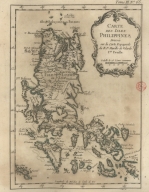
Barcode
3687800354463E
Title
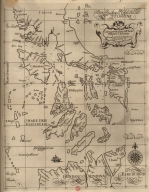
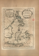
Particular map of Philippine Islands and of Luzon
Contributor
[Dudley, Robert, Sir, 1574-1649, cartographer, Lucini, Antonio Francesco, 1605-1640, engraver, Onofri, Francesco, fl. 1631-1679, printer]
Type
Printed
Barcode
3687800354462D
Title
Particular map of the Strait of Manila in the Philippine Islands
Contributor
[Dudley, Robert, Sir, 1574-1649, cartographer, Lucini, Antonio Francesco, 1605-1640, engraver, Onofri, Francesco, fl. 1631-1679, printer]
Type
Printed
Barcode
3687800354461C
Title
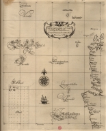
Particular map of the Ladrões Islands with the Island of Gilolo and de Maluku Islands
Contributor
[Dudley, Robert, Sir, 1574-1649, cartographer, Lucini, Antonio Francesco, 1605-1640, engraver, Onofri, Francesco, fl. 1631-1679, printer]
Type
Printed
Barcode
3687800354460B
Title
Particular map of the southern part of Mindanao and northern part of Celebes and Gilolo and with the Maluku Islands and other surrounding islets
Contributor
[Dudley, Robert, Sir, 1574-1649, cartographer, Lucini, Antonio Francesco, 1605-1640, engraver, Onofri, Francesco, fl. 1631-1679, printer]
Type
Printed
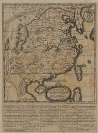
Barcode
3687800354457H
Title
A Map of the 15 Provinces and 155 Capital Cities of the Chinese Empire
Contributor
[Couplet, Philippe, 1623-1692, cartographer, Louvemont, François de, 1648-ca. 1690, engraver, Nolin, Jean-Baptiste, 1648-1708, printer]
Type
Printed
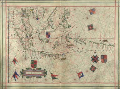
Barcode
3687800354455F
Title
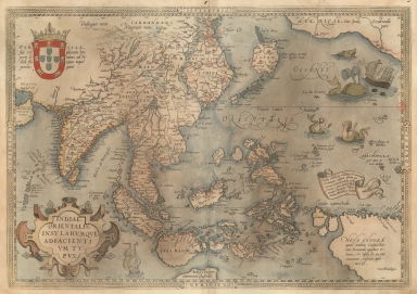
Cambodia, Siam, Borneo, Papua New Guinea
Contributor
[Dourado, Fernão Vaz, 1520-1580, cartographer, Ferron, cavalheiro, former owner, Carlos I, King of Portugal, 1863-1908, former owner, Castelo Branco, João Martens Ferrão de, fl. 1847-1891, former owner]
Type
Manuscript
Barcode
3687800354454E
Title
Carte des Isles Philippines : dressée sur la carte espagnole du R.P. Murillo de Velarde I.re feville
Contributor
[Bellin, Jacques-Nicolas, 1703-1772, cartographer, Murillo Velarde, Pedro, 1696-1753, bibliographic antecedent]
Type
Printed
Barcode
3687800354452C
Title
Far East and Insulindia
Contributor
[Dourado, Fernão Vaz, 1520-1580, cartographer, Ferron, cavalheiro, former owner, Carlos I, King of Portugal, 1863-1908, former owner, Castelo Branco, João Martens Ferrão de, fl. 1847-1891, former owner]
Type
Printed
Barcode
3687800354409E
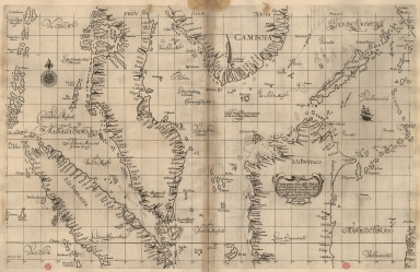
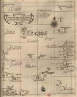
Title
Exacta & accurata delineatio cum orarum maritimarum tum etiam locorum terrestrium quae in regionibus China, Cauchinchina, Camboja sive Champa, Syao, Malac[c]a, Arracan & Pegu, una cum omnium vicinarum insularum descriptione ut sunt Samatra, Java utraq[ue], Timora, Moluccae, Philippinae, Luconia & de Lequeos dictae, nec non insulae Japan & Corea, reliquaeq[ue] omnes adjacentes, ubi etiam adnotavimus scopulos, brevia, omniaq[ue] vadosa loca, & siquae alia a quibus periculum navigantibus. Que madmodum singula hoc aevo à Lusitanis navium gubernatoribus comperta, indigetata, & in tabulas relata fuere. E quorum recentibus ac emendatis tabulis perquàm studiosè haec describi exprimiq[ue] curavimus, in eorum hominum co[m]modum quibus ista usui volupatiq[ue] esse consueuerunnt = The trew description of all the coasts of China, Cauchinchina Camboya, Sӱao, malacca, Arracan, and Pegu, together with all the islands there abowts, both great and smale, with the cliffes, breaches, sands, droughts and shallowes, all perfectly drawne and examined with the most expert cardes of the Portingales pilots.
Contributor
[Linschoten, Jan Huygen van, 1563-1611, cartographer, Beckit, Robert, engraver, Wolfe, John, ca. 1547-1601, printer]
Type
Printed
Barcode
3687800354405A
Title
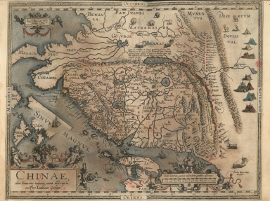
A new representation of China, once called the region of the Chinese, by Ludovicus Georgius.
Contributor
[Barbuda, Luís Jorge de, fl. 1575-1584, cartographer, Plantijnsche Drukkerij, printer]
Type
Printed
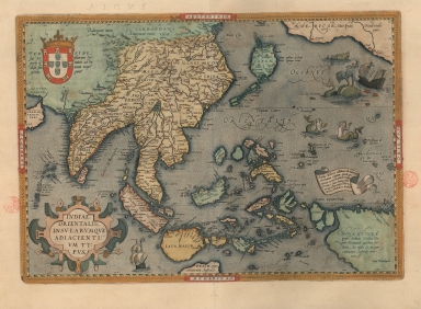
Barcode
3687800354407C
Title
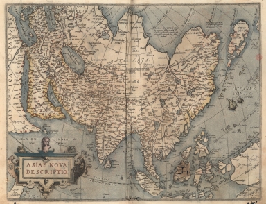
A map of the East Indies and surrounding islands
Contributor
[Ortelius, Abraham, 1527-1598, author, Plantijnsche Drukkerij, printer]
Type
Printed
Barcode
3687800354439H
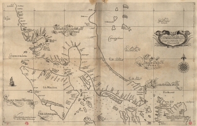
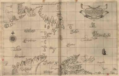
Title
Exacta et accurata delineatio cùm orarum maritimarum tùm etiam locorum terrestrium quae in regionibus China, Cauchinchina, Camboja sive Champa, Syao, Malacca, Arracan et Pegu, unà cum omnium vicinarum insularum descriptione ut sunt Samatra, Java utraq[ue], Timora, Molucca, Philippina, Luconia et de Lequeos dictae, nec non insulae Japan et Corea, reliquaeq[ue] omnes adjacentes, ubi etiam adnotavimus scopulos, brevia, omniaq[ue] vadosa loca, et siqua alia à quibus periculum navigantibus. Que madmodum singula hoc aevo à Lusitanis navium gubernatoribus comperta, indigetata, et in tabulas relata fuere. E quorum recentibus ac emendatis tabulis perquàm studiosè haec describi exprimiq[ue] curavimus, in eorum hominum co[m]modum quibus ista usui volupatiq[ue] esse consueueru[n]t = Waarachtige wtworpinghe oste afbeeldinge van alle die custen ende landen van China, Cauchinchina, Camboja, Sÿao, Malacca, Arracan ende Pegu, mitsgaders alle die biileggende eÿlanden groote ende cleinen, mit noch die clippen, riffen, sanden, droochten ende ondiepten, alles wt de alder correckste pas ende Lees-caarten getrocken die de Portugaloissche Stvÿrlviiden huiidendaechs gebruiicken.
Contributor
[Linschoten, Jan Huygen van, 1563-1611, cartographer, Langren, Arnold Florent van, 1580-1644, illustrator, Langren, Hendrik Floris van, ca.1574-1648, engraver, Claesz, Cornelis, ca. 1546-1609, printer]
Type
Printed
Barcode
3687800354447G
Title
A new representation of China, once called the region of the Chinese, by Ludovicus Georgius.
Contributor
[Barbuda, Luís Jorge de, fl. 1575-1584, cartographer, Cónegos Regrantes de Santo Agostinho. Mosteiro de São Vicente de Fora (Lisboa), former owner]
Type
Printed
Barcode
3687800354448H
Title
A New Depiction of Asia.
Contributor
[Ortelius, Abraham, 1527-1598, author, Cónegos Regrantes de Santo Agostinho. Mosteiro de São Vicente de Fora (Lisboa), former owner]
Type
Printed
Barcode
3687800354449I
Title
A map of the East Indies and surrounding islands.
Contributor
[Ortelius, Abraham, 1527-1598, author, Cónegos Regrantes de Santo Agostinho. Mosteiro de São Vicente de Fora (Lisboa), former owner]
Type
Printed
Barcode
3687800354414A
Title
Carte des Isles Philippines Celebes et Moluques
Contributor
Bellin, Jacques-Nicolas, 1703-1772, cartographer
Type
Printed
1-19 of 19
|
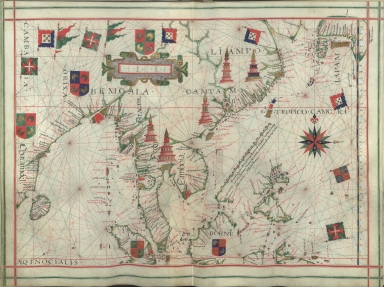
![Exacta & accurata delineatio cum orarum maritimarum tum etiam locorum terrestrium quae in regionibus China, Cauchinchina, Camboja sive Champa, Syao, Malac[c]a, Arracan & Pegu, una cum omnium vicinarum insularum descriptione ut sunt Samatra, Java utraq[ue], Timora, Moluccae, Philippinae, Luconia & de Lequeos dictae, nec non insulae Japan & Corea, reliquaeq[ue] omnes adjacentes, ubi etiam adnotavimus scopulos, brevia, omniaq[ue] vadosa loca, & siquae alia a quibus periculum navigantibus. Que madmodum singula hoc aevo à Lusitanis navium gubernatoribus comperta, indigetata, & in tabulas relata fuere. E quorum recentibus ac emendatis tabulis perquàm studiosè haec describi exprimiq[ue] curavimus, in eorum hominum co[m]modum quibus ista usui volupatiq[ue] esse consueuerunnt = The trew description of all the coasts of China, Cauchinchina Camboya, Sӱao, malacca, Arracan, and Pegu, together with all the islands there abowts, both great and smale, with the cliffes, breaches, sands, droughts and shallowes, all perfectly drawne and examined with the most expert cardes of the Portingales pilots.](http://lunamap.must.edu.mo:80/MediaManager/srvr?mediafile=/Size2/MUST~2~2/325/3687800354409E%28bpe-gav2-pastaC-n55_0001%29.jpg)
![Exacta et accurata delineatio cùm orarum maritimarum tùm etiam locorum terrestrium quae in regionibus China, Cauchinchina, Camboja sive Champa, Syao, Malacca, Arracan et Pegu, unà cum omnium vicinarum insularum descriptione ut sunt Samatra, Java utraq[ue], Timora, Molucca, Philippina, Luconia et de Lequeos dictae, nec non insulae Japan et Corea, reliquaeq[ue] omnes adjacentes, ubi etiam adnotavimus scopulos, brevia, omniaq[ue] vadosa loca, et siqua alia à quibus periculum navigantibus. Que madmodum singula hoc aevo à Lusitanis navium gubernatoribus comperta, indigetata, et in tabulas relata fuere. E quorum recentibus ac emendatis tabulis perquàm studiosè haec describi exprimiq[ue] curavimus, in eorum hominum co[m]modum quibus ista usui volupatiq[ue] esse consueueru[n]t = Waarachtige wtworpinghe oste afbeeldinge van alle die custen ende landen van China, Cauchinchina, Camboja, Sÿao, Malacca, Arracan ende Pegu, mitsgaders alle die biileggende eÿlanden groote ende cleinen, mit noch die clippen, riffen, sanden, droochten ende ondiepten, alles wt de alder correckste pas ende Lees-caarten getrocken die de Portugaloissche Stvÿrlviiden huiidendaechs gebruiicken.](http://lunamap.must.edu.mo:80/MediaManager/srvr?mediafile=/Size2/MUST~2~2/346/3687800354439H%28cc-804-v_0001%29.jpg)
![[Southeast China, Japan, East Indies (northern part)]](http://lunamap.must.edu.mo:80/MediaManager/srvr?mediafile=/Size2/MUST~2~2/45/000434.jpg)