Detail View: Old Maps Collection: Carte des côtes de l'Amérique et de l'Asie : depuis la Californie jusqu'à Macao
|
Barcode:
|
4687820500131
|
|
Title:
|
Carte des côtes de l'Amérique et de l'Asie : depuis la Californie jusqu'à Macao
|
|
Original Title:
|
Carte des côtes de l'Amérique et de l'Asie : depuis la Californie jusqu'à Macao
|
|
Contributor:
|
La Pérouse, Jean-François de Galaup, comte de, 1741-1788
|
|
Category:
|
Sea Charts
|
|
Type:
|
Printed
|
|
Language:
|
French
|
|
Create Year:
|
1797
|
|
Format:
|
JPEG, 9596 × 6852, 59.9MB
|
|
Scale:
|
Scale not given
|
|
Note:
|
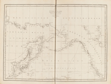
Macao and the surrounding islands were depicted in this map.
|
|
Note:
|
This map described the French explorer Jean Francois Galaup Comte de La Pérouse led by astronomers and Geographer in 1786. He crossed the Pacific Ocean arrived Macao,and via the Philippines and then sailed north to the Kamchatka Peninsula. Macao and the surrounding islands were depicted in this map , zigzag lines on the drawing to record the navigation route . When La Pérouse arrived at macao, he sold the furs acquired in Alaska and visited Bernardo Aleixo de Lemos e Faria who was the Governor of Macau.
|
|
Note:
|
Macao in China Maps; Macao in Asia Maps
|
|
Note:
|
Macao in Routes
|
|
Subject:
|
Voyages around the world
|
|
Subject:
|
Discoveries in geography
|
|
Geographic Area:
|
Pacific Ocean
|
|
Geographic Area:
|
Northeastern Asia
|
|
Geographic Area:
|
North America
|
|
Geographic Area:
|
China
|
|
Geographic Area:
|
Taiwan
|
|
Geographic Area:
|
Japan
|
|
Geographic Area:
|
Korea
|
|
Pub Title:
|
Voyage de La Pérouse autour du Monde
|
|
Pub Author:
|
La Pérouse, Jean-François de Galaup, comte de, 1741-1788
|
|
Pub Year:
|
1797
|
|
Pub location:
|
Paris
|
|
Provenance:
|
Harvard Map Collection - Harvard College Library
|