Detail View: Old Maps Collection: [Carte de l'Océan Indien, des cotes de l'Afrique et de l'Asie depuis le cap de Bonne-Espérance jusqu'au Japon]
|
Barcode:
|
4687820501030
|
|
Title:
|
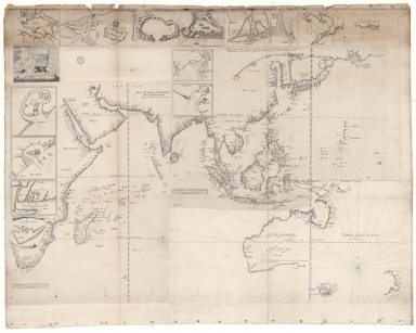
[Carte de l'Océan Indien, des cotes de l'Afrique et de l'Asie depuis le cap de Bonne-Espérance jusqu'au Japon]
|
|
Other Title:
|
[Indes Orientales, de Teixeira]
|
|
Other Title:
|
[Carte de Texeira]
|
|
Other Title:
|
[Sea chart of the coasts from the Cape of Good Hope to Ceylon, with the Red Sea, Persian Gulf and Madagascar].
|
|
Other Title:
|
[Sea chart the coasts from Ceylon to Japan].
|
|
Other Title:
|
Ilha de Goa.
|
|
Other Title:
|
Arracão.
|
|
Other Title:
|
Ormuz.
|
|
Other Title:
|
Fortaleza de Mascate na Costa de Arabia.
|
|
Other Title:
|
Fortaleza de Dio.
|
|
Other Title:
|
Pegu.
|
|
Other Title:
|
Japon.
|
|
Other Title:
|
Batavia.
|
|
Other Title:
|
Bengala.
|
|
Other Title:
|
Mo[m]baça.
|
|
Other Title:
|
Chatigão.
|
|
Other Title:
|
Mosanbique.
|
|
Other Title:
|
Sofala.
|
|
Other Title:
|
Ilha de Sacatora.
|
|
Contributor:
|
Albernaz, João Teixeira, fl. 1602-1649, cartographer
|
|
Category:
|
Sea Charts
|
|
Type:
|
Manuscripts
|
|
Language:
|
Portuguese
|
|
Language:
|
French
|
|
Language:
|
Dutch
|
|
Create Year:
|
[ca. 1649]
|
|
Format:
|
JPEG 2000, 15230 x 12177, 27MB
|
|
Scale:
|
Scale not given.
|
|
Physical Map Dimension (cm):
|
92 x 123 cm, on sheet 112 x 138 cm
|
|
Note:
|
This is a mounted map from two sea charts and twelve insets of cartographer, chart maker and cosmographer to the King of Portugal, João Teixeira Albernaz; and one sea chart and two insets by unknown author. This last sea chart depicts the Oceania region and the insets are of Batavia and Japan. The mounted map depicts the Indian Ocean across the eastern coast of Africa from the Cape of Good Hope; Arabian Peninsula; India; Malay Peninsula to Malacca; Madagascar -named 'Ilha de Saõ Lourenso"-; Sri Lanka -as 'Ceilaõ'-; Samatra; Java and Timor; Australia -written as 'Hollandia nova'- and New Zealand. There are also twelve insets with cities and fortresses of Oriental India, one of Batavia and the other of Japan. The three sea charts together with the insets of Mombasa, Mozambique, Sofala, Socotra, Bengal and Chittagong were published in the 'Relations de divers voyages curieux' by Melchisédec Thévenot. Only one sea chart of Teixeira is signed and dated but both are obviously drawn en série. The insets of Goa, Arakan, Ormuz, Mascate, Diu and Pegu are unsigned but are undoubtedly based on a 1649 manuscript chart by João Teixeira also at the Bibliothèque Nationale de France. The Batavia inset is made in an obvious different style -but just as the insets of Mascate and Diu- is in a bird's-eye view.
|
|
Note:
|
Sea chart of the coasts from the Cape of Good Hope to Ceylon, with the Red Sea, Persian Gulf and Madagascar. - Signed 'João Teixeira cosmographo de sua magestade a féz em Lixboa o anno de 1649'. - 69 x 49 cm. -- Sea chart the coasts from Ceylon to Japan. - 50 x 66 cm. -- Inset 1: 'Ilha de Goa'. - 11 x 14 cm. -- Inset 2: 'Arracão'. - 11 x 11 cm. -- Inset 3: 'Ormuz'. - 11 x 12 cm. -- Inset 4: 'Fortaleza de Mascate na Costa de Arabia'. - 11 x 13 cm. -- Inset 5: 'Fortaleza de Dio'. - 11 x 14 cm. -- Inset 6: 'Pegu'. - 11 x 22 cm. -- Inset 7: 'Japon'. - 11 x 28 cm. -- Inset 8: 'Batavia'. - 11 x 14 cm. -- Inset 9: 'Bengala'. - 10 x 12 cm. -- Inset 10: 'Mo[m]baça'. - 16 x 15 cm. -- Inset 11: 'Chatigão'. - 10 x 12 cm. -- Inset 12: 'Mosanbique'. - 14 x 14 cm. -- Inset 13: 'Sofala'. - 11 x 14 cm. -- Inset 14: 'Ilha de Sacatora'. - 9 x 11 cm.
|
|
Note:
|
Original is a printed mounted map, 100 x 126 cm. On the back it has glued a printed paper with the tittle 'Indes Orientales, de Teixeira' outlined in double fillet signed 'E.' and a manuscript note 'Carte de Texeira'.
|
|
Note:
|
Title form the provenance library.
|
|
Note:
|
Relief is shown pictorially on land and bathymetric relief is shown by isolines and soundings.
|
|
Note:
|
Scale lines shown only on the João Teixeira charts, bottom left corner and under the Equator left to Samatra outlined in double fillet.
|
|
Note:
|
There are three 32-point compass roses with a fleur-de-lis indicating north, two of them on the sea charts of João Teixeira and the other on the Oceania chart.
|
|
Note:
|
The insets of Mombasa, Mozambique, Sofala, Socotra and Japan have a compass rose indicating north.
|
|
Note:
|
Sea charts by João Teixeira with graticule.
|
|
Note:
|
Macao in East Indies Maps.
|
|
Reference:
|
Tooley’s dict. of mapmakers, [1] A-D, p. 16
|
|
Reference:
|
Cortesão, A. Portugaliae Monumenta Cartographica, vol. 4, p. 147-149
|
|
Geographic Area:
|
China
|
|
Geographic Area:
|
Asia
|
|
Geographic Area:
|
Africa
|
|
Geographic Area:
|
Indian Ocean
|
|
Geographic Area:
|
Pacific Ocean
|
|
Geographic Area:
|
New Zealand
|
|
Geographic Area:
|
Australia
|
|
Geographic Area:
|
Hurmuz (Iran)
|
|
Geographic Area:
|
Socotra (Yemen)
|
|
Geographic Area:
|
Goa
|
|
Geographic Area:
|
Oman
|
|
Geographic Area:
|
Mombasa
|
|
Geographic Area:
|
Mozambique
|
|
Geographic Area:
|
Nova Sofala (Mozambique)
|
|
Geographic Area:
|
Bengal (India)
|
|
Geographic Area:
|
Chittagong (Bangladesh)
|
|
Geographic Area:
|
Korea
|
|
Geographic Area:
|
Japan
|
|
Geographic Area:
|
Borneo
|
|
Geographic Area:
|
Philippines
|
|
Geographic Area:
|
Thailand
|
|
Geographic Area:
|
Vietnam
|
|
Geographic Area:
|
India
|
|
Geographic Area:
|
Malacca (Malacca, Malaysia)
|
|
Geographic Area:
|
Sumatra (Indonesia)
|
|
Geographic Area:
|
Singapore
|
|
Geographic Area:
|
Java (Indonesia)
|
|
Geographic Area:
|
Paracel Islands
|
|
Provenance:
|
Bibliothèque Nationale de France
|
|
Provenance:
|
https://catalogue.bnf.fr/ark:/12148/cb43545881t
|
|
Provenance Call No.:
|
GE SH 18 PF 213 DIV 3 P 2-2
|
|
MUST holding:
|
https://must.primo.exlibrisgroup.com/permalink/853MUST_INST/171sgkf/alma991002924149705076
|