Detail View: Old Maps Collection: [Carte portugaise de la mer des Indes entre le Cap de Bonne Espérance et le Cap Comorin]
|
Barcode:
|
4687820501029
|
|
Title:
|
[Carte portugaise de la mer des Indes entre le Cap de Bonne Espérance et le Cap Comorin] ; [Carte portugaise de la mer qui comprend le Golfe du bengale, les côtes de la Chine et les îles du Japon, Philippines, de la Sonde et Moluques]
|
|
Title:
|
[Carte portugaise de la mer des Indes entre le Cap de Bonne Espérance et le Cap Comorin]
|
|
Other Title:
|
Mo[m]baça.
|
|
Other Title:
|
Mosanbique.
|
|
Other Title:
|
Sofala.
|
|
Contributor:
|
Albernaz, João Teixeira, fl. 1602-1649, cartographer
|
|
Category:
|
Sea Charts
|
|
Type:
|
Printed
|
|
Language:
|
Portuguese
|
|
Language:
|
French
|
|
Create Year:
|
1649
|
|
Format:
|
JPEG 2000, 6256 x 8688, 11MB
|
|
Page No.:
|
1
|
|
Scale:
|
Scale not given.
|
|
Physical Map Dimension (cm):
|
69 x 50 cm, on sheet 89 x 54 cm
|
|
Note:
|
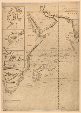
This is a printed mounted map in two sheets of a sea chart with 5 insets by cartographer, chart maker and cosmographer to the King of Portugal, João Teixeira Albernaz. In fact, the chart is almost an identical copy of the manuscript maps [Carte de l'Océan Indien] by the same author and of the same year, also in the Bibliothèque Nationale de France. On the nautical chart are depicted the Indian Ocean across the eastern coast of Africa from the Cape of Good Hope; the Arabian Peninsula and Madagascar -named 'Ilha de Saõ Lourenso". The insets are of cities and fortresses of Africa and Oriental India. Only this sheet is signed and dated but both are obviously drawn en série.
|
|
Note:
|
Sheet 1: [Carte portugaise de la mer des Indes entre le Cap de Bonne Espérance et le Cap Comorin]. - 69 x 50 cm. - Inset 1: Mo[m]baça. - 15 x 14 cm. - Inset 2: Mosanbique. - 13 x 14 cm. - Inset 3: Sofala. - 11 x 14 cm.
|
|
Note:
|
Original is a copperplate printed map in two sheets, 72 x 52 cm and 53 x 75 cm.
|
|
Note:
|
Title form provenance library.
|
|
Note:
|
There is a 32-point compass roses with a fleur-de-lis indicating north. The insets of Mombasa, Mozambique and Sofala have a 4-point compass rose with an arrow indicating north.
|
|
Note:
|
Relief is shown pictorially on land and bathymetric relief is shown by isolines and soundings.
|
|
Note:
|
Scale lines shown on the bottom left corner of each sheet.
|
|
Note:
|
Map with graticule.
|
|
Note:
|
Macao in East Indies Maps.
|
|
Reference:
|
Tooley’s dict. of mapmakers, [1] A-D, p. 16
|
|
Reference:
|
Cortesão, A. Portugaliae Monumenta Cartographica, vol. 4, p. 147-149
|
|
Subject:
|
Indian Ocean-- Maps
|
|
Geographic Area:
|
Indian Ocean
|
|
Geographic Area:
|
Africa
|
|
Geographic Area:
|
Mombasa
|
|
Geographic Area:
|
Mozambique
|
|
Geographic Area:
|
Nova Sofala (Mozambique)
|
|
Geographic Area:
|
India
|
|
Provenance:
|
Bibliothèque Nationale de France
|
|
Provenance:
|
https://catalogue.bnf.fr/ark:/12148/cb406448026
|
|
Provenance Call No.:
|
GE DD-2987 (9668 B-9669 B)
|
|
MUST holding:
|
https://must.primo.exlibrisgroup.com/permalink/853MUST_INST/171sgkf/alma991002988048905076
|