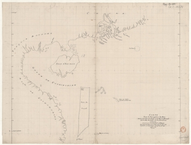
Detail View: Old Maps Collection: Carte pour la navigation des mers entre les cotes de Chine et du Blanc le Paracel et de celles du Golfe de Cochinchine : dressée sur une carte MS.te a M.r Bouvet qui contenoit depuis le 2.e deg. jusq.' 24.e dont cette 1.ere feuille ne comprend que du 24.e au 13.e degré.
|
Barcode:
|
4687820501015
|
|
Title:
|
Carte pour la navigation des mers entre les cotes de Chine et du Blanc le Paracel et de celles du Golfe de Cochinchine : dressée sur une carte MS.te a M.r Bouvet qui contenoit depuis le 2.e deg. jusq.' 24.e dont cette 1.ere feuille ne comprend que du 24.e au 13.e degré.
|
|
Contributor:
|
Bouvet, 16---17--, bibliographic antecedent
|
|
Category:
|
Sea Charts
|
|
Type:
|
Manuscripts
|
|
Language:
|
French
|
|
Create Year:
|
1737
|
|
Format:
|
JPEG 2000, 8504 x 6477, 82MB
|
|
Scale:
|
Scale not given.
|
|
Physical Map Dimension (cm):
|
53 x 70 cm, on sheet 62 x 78 cm
|
|
Note:
|
This is a stylized map of the coasts of China and Vietnam with Hainan Island. As stated by the title this is a chart that provides navigational aid on the coasts of China, the Paracel Islands and the Gulf of Tonkin. However, no notes or even soundings are provided. All the interior of the landmasses is blank and only a few islands on the mouth of the Pearl River are named. Macao is identified as an island rather than a peninsula.
|
|
Note:
|
Original is a manuscript map, 53 x 70 cm.
|
|
Note:
|
Latitude line on both sides of the map.
|
|
Note:
|
Map with graticule.
|
|
Note:
|
Macao in China maps.
|
|
Subject:
|
China -- Maps
|
|
Subject:
|
Macao (China) -- Maps
|
|
Subject:
|
Vietnam -- Maps
|
|
Geographic Area:
|
China
|
|
Geographic Area:
|
Macao (China)
|
|
Geographic Area:
|
Vietnam
|
|
Geographic Area:
|
Hainan Sheng (China)
|
|
Geographic Area:
|
Paracel Islands
|
|
Geographic Area:
|
South China Sea
|
|
Provenance:
|
Bibliothèque Nationale de France
|
|
Provenance:
|
https://catalogue.bnf.fr/ark:/12148/cb407771828
|
|
Provenance Call No.:
|
GE C-11224
|
|
MUST holding:
|
https://must.primo.exlibrisgroup.com/permalink/853MUST_INST/171sgkf/alma991002988949405076
|