Detail View: Old Maps Collection: [Observations publiées en 1646-1648 par Robert Dudley, Atlantique, Méditerranée, Océan Indien, Mer de Chine]
|
Barcode:
|
4687820501013
|
|
Title:
|
[Observations publiées en 1646-1648 par Robert Dudley, Atlantique, Méditerranée, Océan Indien, Mer de Chine]
|
|
Contributor:
|
Delisle, Guillaume, 1675-1726, cartographer
|
|
Contributor:
|
Dudley, Robert, Sir, 1574-1649, bibliographic antecedent
|
|
Category:
|
Sea Charts
|
|
Type:
|
Manuscripts
|
|
Language:
|
French
|
|
Create Year:
|
[17--]
|
|
Format:
|
JPEG 2000, 6240 x 7456, 90MB
|
|
Scale:
|
Scale not given.
|
|
Physical Map Dimension (cm):
|
56 x 49 cm, on sheet 71 x 62 cm
|
|
Note:
|
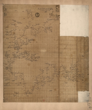
This map was drawn by Guillaume Delisle after observations published by Robert Dudley on the work ' Dell'Arcano del Mare' (The Secret of the Sea), the first maritime atlas to cover the whole world. At the age of 27, Delisle was admitted into the French Académie Royale des Sciences and started to sign his maps with the title 'Géographe de l’Académie'. Like many cartographers of his time, Delisle did not travel with explorers. He drew maps mostly in his office, relying on a solid network to provide him first-hand information. Given his family's and his own reputation, he had access to fairly recent accounts of travellers who were returning from the New World. This rather stylized chart with a sense of unfinished work depicts Europe, with part of the Greenland on the upper border of the map, Africa and the East Indies. The toponyms found on the map are of the most important cities of each place, in more abundance in Europe and much more scarce in Asia, but Macao is already marked, stating its importance. Scattered all over the map are latitude and longitude degrees.
|
|
Note:
|
Original is a manuscript map, 56 x 50 cm.
|
|
Note:
|
Title from provenance library.
|
|
Note:
|
Latitude line on the left side of the map.
|
|
Note:
|
Map with graticule.
|
|
Note:
|
Macao in East Indies maps.
|
|
Subject:
|
China -- Maps
|
|
Geographic Area:
|
Europe
|
|
Geographic Area:
|
Mediterranean Sea
|
|
Geographic Area:
|
Africa
|
|
Geographic Area:
|
Southeast Asia
|
|
Geographic Area:
|
Indian Ocean
|
|
Provenance:
|
Bibliothèque Nationale de France
|
|
Provenance:
|
https://catalogue.bnf.fr/ark:/12148/cb40592175v
|
|
Provenance Call No.:
|
GE SH 18 PF 1 DIV 0 P 10/4 D
|
|
MUST holding:
|
https://must.primo.exlibrisgroup.com/permalink/853MUST_INST/171sgkf/alma991002991549805076
|