Detail View: Old Maps Collection: [Indian Ocean from the Cape of Good Hope to Banda and from the Black Sea to Japan, Arabia, Persia, India, Indo-china and Insulinde, South China, Japan]
|
Barcode:
|
4687820501012
|
|
Title:
|
[Indian Ocean from the Cape of Good Hope to Banda and from the Black Sea to Japan, Arabia, Persia, India, Indo-china and Insulinde, South China, Japan]
|
|
Original Title:
|
[Océan Indien depuis le "c. de bona esperansa" jusqu'à "banda" et de la Mer Noire jusqu'au "Japam", Arabie, Perse, Inde, Indo-chine et Insulinde, Chine du sud, "Japam"]
|
|
Other Title:
|
Asia Portolan
|
|
Contributor:
|
Angelus, author
|
|
Category:
|
Sea Charts
|
|
Type:
|
Manuscripts
|
|
Language:
|
Portuguese
|
|
Create Year:
|
[1575]
|
|
Format:
|
JPEG 2000, 9739 x 7348, 92MB
|
|
Page No.:
|
6
|
|
Scale:
|
Scale not given.
|
|
Physical Map Dimension (cm):
|
37 x 28 cm, on sheet 40 x 30 cm
|
|
Note:
|
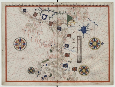
This chart belongs to the manuscript 'Portulan de la Méditerranée, des côtes de Portugal, Espagne, France, Pays-Bas, Allemagne, Angleterre, d'Afrique, Arabie, Inde, Chine, Iles de la Sonde, etc., et de l'Amérique du Nord et du Sud' that even though it was made in France it is obviously from Portuguese sources, for not only the making of the charts ressembles those from Portuguese cartographers but also most, if not the entirety, of place names is written in Portuguese especially in this Asia map. Some of the notes are also written in Portuguese, like on the land mass east to the Paracel Islands. Just as in Portuguese sea charts a lot of detail in given to coast lines with an extensive of place names but almost none on land.
|
|
Note:
|
Original is a manuscript chart from the 'Portulan de la Méditerranée, des côtes de Portugal, Espagne, France, Pays-Bas, Allemagne, Angleterre, d'Afrique, Arabie, Inde, Chine, Iles de la Sonde, etc., et de l'Amérique du Nord et du Sud', in two parchment sheets mounted, 30 x 40 cm.
|
|
Note:
|
Title from provenance library.
|
|
Note:
|
There are 10 coats of arms on the map, five of them being the Portuguese coat of arms and the other five with the Cross of the Order of Christ.
|
|
Note:
|
Jerusalem is marked as a Calvary with the three crosses painted gold. There are four 32-point compass roses on the map. The one in the top middle part of the chart has a fleur de lis indicating north. They are colored red, blue, green and gold. The rhumb lines for the principal winds are black, for the half winds green and the quarter winds red.
|
|
Note:
|
Table of leagues inside gold cartouche.
|
|
Note:
|
Latitude line on the left side of the map in blue and yellow interchangeably.
|
|
Note:
|
Relief shown pictorially.
|
|
Note:
|
Landmasses outlined in gold with islands colored red, blue and green. The Nile and the Caspian Sea colored blue.
|
|
Note:
|
Map outlined in red border.
|
|
Note:
|
Place names written both in black and red.
|
|
Reference:
|
Deulin, G. Catalogue des portulans et pièces assimilables ou connexes du Service hydrographique de la Marine, p. 70 bis
|
|
Subject:
|
China -- Maps
|
|
Subject:
|
Europe -- Maps
|
|
Subject:
|
Africa -- Maps
|
|
Subject:
|
Arabian Peninsula -- Maps
|
|
Geographic Area:
|
China
|
|
Geographic Area:
|
Europe
|
|
Geographic Area:
|
Africa
|
|
Geographic Area:
|
Arabian Peninsula
|
|
Relation Note:
|
[6]
|
|
Pub Title:
|
Portulan de la Méditerranée, des côtes de Portugal, Espagne, France, Pays-Bas, Allemagne, Angleterre, d'Afrique, Arabie, Inde, Chine, Iles de la Sonde, etc., et de l'Amérique du Nord et du Sud
|
|
Pub Author:
|
Angelus
|
|
Pub Year:
|
In Masilia
|
|
Pub location:
|
1575
|
|
Provenance:
|
Bibliothèque Nationale de France
|
|
Provenance:
|
https://archivesetmanuscrits.bnf.fr/ark:/12148/cc571874
|
|
Provenance Call No.:
|
Français 9669
|
|
MUST holding:
|
https://must-primo.exlibris.com.cn/permalink/853MUST_INST/171sgkf/alma991002973149705076
|