Detail View: Old Maps Collection: Carte particuliere de l'entrée de la Riviere de Canton
|
Barcode:
|
3687800354676K
|
|
Title:
|
Carte particuliere de l'entrée de la Riviere de Canton
|
|
Original Title:
|
Carte particuliere de l'entree de la riviere de Canton.
|
|
Category:
|
Sea Charts
|
|
Type:
|
Manuscripts
|
|
Language:
|
French
|
|
Create Year:
|
[17--]
|
|
Format:
|
JPEG 2000, 8957 x 6564, 94MB
|
|
Scale:
|
[ca 1:111,000].
|
|
Physical Map Dimension (cm):
|
47 x 67 cm, on sheet 64 x 76 cm
|
|
Note:
|
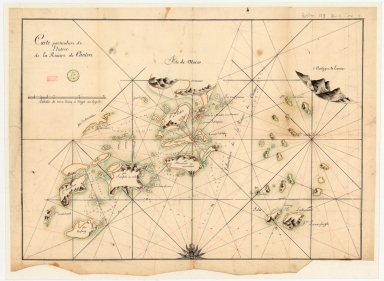
Macao and its surroundings
|
|
Note:
|
This is a manuscript chart of Macao and its surroundings extending from Hebao Dao (Isle Kosang) on the west to Lantau (Montagne de Lamtao) on the east. The navigational use of the map is clear with the marking if sand banks, shoals and shallow bottoms and the placement of anchorage points, portraying a total of six. Xiangshan Island is only partly drawn and marked “Isle de Macao” [Macao Island], as was customary on western maps of this period, but it also presents the toponym “Onmooue” from the Cantonese pronunciation of Aomen (澳門, Ou Mun). The Macao Peninsula is named “Ville de Macao” [Macao City] or “Macane”, which is a rather uncommon and rare spelling. Duimian Shan appears as “I.le S.t Pedro” [Saint Peter’s Island], a spelling mistake of the Portuguese word “padre” [priest], for the island was commonly known amongst them as “Ilha dos Padres” [Priest’s Island] because of the Jesuit presence there. Only Macao and Duimian Shan are represented with illustrations of buildings, with a church and a fortress easily perceived in the latter. The nomenclature present in it is very peculiar and unique as it seems to have been taken from a combination of Portuguese, Spanish, Dutch, Latin and Cantonese source materials, all merged into an unusual French spelling.
|
|
Note:
|
Original is a manuscript map, 54 x 74 cm.
|
|
Note:
|
There is a half 32-point compass rose with a fleur-de-lis indicating north on the lower center. where there can be seen a face in the middle and another two inside the triangles of the principal winds, as well as flame-like motifs for the quarter-winds.
|
|
Note:
|
Scale line in leagues underneath the title on the left upper corner of the map.
|
|
Note:
|
Relief is shown pictorially with bathymetric relief by soundings.
|
|
Note:
|
Landmasses outlined in yellow and green shading on the water.
|
|
Note:
|
Map outlined in double fillet.
|
|
Note:
|
Macao and its surroundings.
|
|
Subject:
|
China -- Maps
|
|
Subject:
|
Macao (China) -- Maps
|
|
Geographic Area:
|
Pearl River Estuary (China)
|
|
Geographic Area:
|
Guangdong Sheng (China)
|
|
Geographic Area:
|
Macao (China)
|
|
Provenance:
|
Bibliothèque Nationale de France
|
|
Provenance:
|
https://catalogue.bnf.fr/ark:/12148/cb45089013b
|
|
Provenance Call No.:
|
GE SH 18 PF 179 DIV 9 P 4
|
|
MUST holding:
|
https://must.primo.exlibrisgroup.com/permalink/853MUST_INST/171sgkf/alma991003073549805076
|