Detail View: Old Maps Collection: English chart of the island of Amoy
|
Barcode:
|
3687800354570D
|
|
Title:
|
English chart of the island of Amoy
|
|
Original Title:
|
[Carte anglaise de l'île d'Amoy]
|
|
Contributor:
|
Thornton, John, 1641-1708, cartographer
|
|
Category:
|
Sea Charts
|
|
Type:
|
Manuscripts
|
|
Language:
|
English
|
|
Create Year:
|
[ca. 1700]
|
|
Format:
|
JPEG 2000, 7008 x 8672, 99MB
|
|
Scale:
|
Scale not given.
|
|
Physical Map Dimension (cm):
|
71 x 56 cm, on sheet 76 x 68 cm
|
|
Note:
|
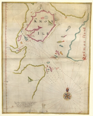
This is an anonymous chart of Xiamen, also known as Amoy from Hokkien pronunciation, beside the Taiwan Strait, with the western coast of Kinmen county (Quimoy iland). The Portuguese first reached Xiamen in 1541 but it was The British East India Company traded extensively with the port, constructing a factory there in 1678, marked on the map as 'English factory'. The trade and continued until the imposition of the Canton System, however, despite restricting Western trade to the port of Guangzhou, the Spanish were still allowed to trade in Xiamen. Nonetheless, they rarely used this privilege as Chinese traders would ship their goods from Xiamen to Manila and vice versa, which was more profitable for both sides. The chart displays quite a number of soundings and tidal heights for entering the bay and approaching the port. This is a very similar chart to one signed by John Thornton in the year 1699, however, neither the writing nor the motif of the compass rose correspond. Also the present chart has an informative legend on the left bottom corner of the map.
|
|
Note:
|
Original is a manuscript watercolor chart on parchment, 71 x 56 cm.
|
|
Note:
|
Title from provenance library.
|
|
Note:
|
There is a 32-point compass rose with a fleur-de-lis indicating north, colored red, blue, yellow and green. The rhumb lines for the principal winds are black, half-winds in green and quarter-winds in red.
|
|
Note:
|
Latitude line on the left border of the map in red and yellow interchangeably.
|
|
Note:
|
Relief shown pictorially and bathymetric relief by soundings.
|
|
Note:
|
Toponyms in black and red.
|
|
Note:
|
Landmasses outlined in blue, green and magenta with islands colored in blue, green, magenta and yellow.
|
|
Note:
|
Map in yellow border.
|
|
Reference:
|
Foncin, M. Catalogue des cartes nautiques sur vélin conservées au Département des cartes et plans, p. 296
|
|
Reference:
|
Pflederer, R. Census of Portolan Charts & Atlases: as reported and listed by the noted scholars of the genre in their works ranging from 1897 to 2008, p. 68
|
|
Subject:
|
China -- Maps
|
|
Geographic Area:
|
China
|
|
Geographic Area:
|
Xiamen Region (Fujian Sheng, China)
|
|
Provenance:
|
Bibliothèque Nationale de France
|
|
Provenance:
|
https://catalogue.bnf.fr/ark:/12148/cb40781803t
|
|
Provenance Call No.:
|
GE SH 18 PF 179 DIV 15 P 5/2 RES
|
|
MUST holding:
|
https://must.primo.exlibrisgroup.com/permalink/853MUST_INST/1dp55m9/alma991003012949705076
|