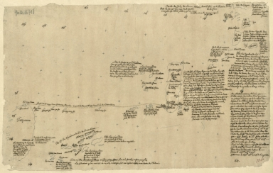
Detail View: Old Maps Collection: Carte des Isles de Lieou-Kieou dont le roi est tributaire de la Chine : Cette Carte est l'ouvrage du P. Gaubil, envoyée à M. L'Abbé Sallier qui l'a reçue en 1752, et me la communiquée aussitôt.
|
Barcode:
|
4687820501008
|
|
Title:
|
Carte des Isles de Lieou-Kieou dont le roi est tributaire de la Chine : Cette Carte est l'ouvrage du P. Gaubil, envoyée à M. L'Abbé Sallier qui l'a reçue en 1752, et me la communiquée aussitôt.
|
|
Contributor:
|
Gaubil, Antoine, 1689-1759, bibliographic antecedent
|
|
Contributor:
|
Sallier, Claude, 1685-1761, correspondent
|
|
Category:
|
Sea Charts
|
|
Type:
|
Manuscripts
|
|
Language:
|
French
|
|
Create Year:
|
1752
|
|
Format:
|
JPEG 2000, 8804 x 5599, 99MB
|
|
Scale:
|
[ca. 1:2,330,000].
|
|
Physical Map Dimension (cm):
|
34 x 55 cm, on sheet 35 x 56 cm
|
|
Note:
|
The map depicts the Japanese Ryukyu Islands on which, according to the title of the map, the king is a tributary of China. In fact, in 1655 the tributary relations between Ryukyu and Qing were formally approved by the shogunate and terminated only in 1874. The map is fairly detailed with all the islands named and some of them with thorough notes on fauna, flora, inhabitants, administration and sometimes history.
|
|
Note:
|
Original is a manuscript map, 33 x 54 cm.
|
|
Note:
|
Map depicts latitude and longitude.
|
|
Subject:
|
China -- Maps
|
|
Geographic Area:
|
Japan
|
|
Geographic Area:
|
Ryukyu Islands
|
|
Provenance:
|
Bibliothèque Nationale de France
|
|
Provenance:
|
https://catalogue.bnf.fr/ark:/12148/cb40658004v
|
|
Provenance Call No.:
|
GE D-16718
|
|
MUST holding:
|
https://must.primo.exlibrisgroup.com/permalink/853MUST_INST/171sgkf/alma991002992949705076
|