Detail View: Old Maps Collection: Typus Orbis Terrarum
|
Barcode:
|
4687820501001
|
|
Title:
|
Typus Orbis Terrarum
|
|
Other Title:
|
Atlas of the Duchess de Berry
|
|
Contributor:
|
Albernaz, João Teixeira, fl. 1602-1649, cartographer
|
|
Contributor:
|
Berry, Marie-Caroline de Bourbon-Sicile, duchesse de, 1798-1870, former owner
|
|
Contributor:
|
Aunay, Jean-Charles de Mesgrigny d', comte, 1680-1763, former owner
|
|
Category:
|
Sea Charts
|
|
Type:
|
Manuscripts
|
|
Language:
|
Latin
|
|
Create Year:
|
[ca. 1628]
|
|
Format:
|
JPEG 2000, 4676 x 3277, 21MB
|
|
Page No.:
|
1
|
|
Scale:
|
Scale not given.
|
|
Physical Map Dimension (cm):
|
22 x 36 cm, on sheet 35 x 42 cm
|
|
Note:
|
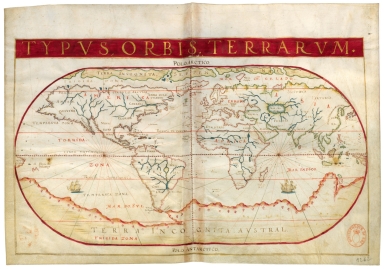
This is an anonymous atlas under the assigned title 'Atlas nautique du monde'. It is attributed to João Albernaz Teixeira and dated around 1628 by Armando Cortesão after analyzing all the charts and comparing it with other works by the same author. The original atlas has two ex libris, one of Jean-Charles de Mesgrigny and the other of the Duchesse de Berry. This is world map of the known world where all continents are already present with the exception of Oceania. Instead there is still present the huge imaginary South Continent (Terra Incognita Austral).
|
|
Note:
|
Original is map from an atlas of 20 charts on parchment by João Teixeira Albernaz, 27 x 28 cm.
|
|
Note:
|
Two sail ships, one on the Indian Ocean and the other on the Pacific South.
|
|
Note:
|
Relief shown pictorially.
|
|
Note:
|
Landmasses outlined in green with bigger islands colored magenta. Small islands colored red, blue and gold.
|
|
Note:
|
Equator line is a longitude line in red and white interchangeably. The lines for the Tropics of Cancer and Capricorn and the two Polar Circles colored red.
|
|
Note:
|
Map outlined in gold.
|
|
Note:
|
Place names written both in black and red.
|
|
Reference:
|
Cortesão, A. Portugaliae Monumenta Cartographica, vol. 4, p. 107-110
|
|
Reference:
|
Foncin, M. Catalogue des cartes nautiques sur vélin conservées au Département des cartes et plans, nº 82
|
|
Reference:
|
Pflederer, R.L. Census of Portolan Charts & Atlases: as reported and listed by the noted scholars of the genre in their works ranging from 1897 to 2008, p. 56
|
|
Subject:
|
World -- Maps
|
|
Geographic Area:
|
World
|
|
Geographic Area:
|
North America
|
|
Geographic Area:
|
Central America
|
|
Geographic Area:
|
South America
|
|
Geographic Area:
|
Europe
|
|
Geographic Area:
|
Africa
|
|
Geographic Area:
|
Asia
|
|
Relation Note:
|
[1]
|
|
Pub Title:
|
[Atlas nautique du monde]
|
|
Pub Author:
|
Albernaz, João Teixeira, fl. 1602-1649
|
|
Pub Year:
|
[ca. 1628]
|
|
Pub location:
|
[S.l.]
|
|
Provenance:
|
Bibliothèque Nationale de France
|
|
Provenance:
|
https://catalogue.bnf.fr/ark:/12148/cb40780659n
|
|
Provenance Call No.:
|
GE FF-14409 (RES)
|
|
MUST holding:
|
https://must.primo.exlibrisgroup.com/permalink/853MUST_INST/reglfj/alma991002991849805076
|