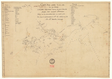
Detail View: Old Maps Collection: Carte d'une partie de la côte de la Chine et des îles adjacentes depuis la pierre blanche jusqu'à l'isle nommée l'Artimon tracée sur les observations faites en 1759 & 1760 du senau Le Goudelours du v.au Le Londres en 1764
|
Barcode:
|
3687800354681G
|
|
Title:
|
Carte d'une partie de la côte de la Chine et des îles adjacentes depuis la pierre blanche jusqu'à l'isle nommée l'Artimon tracée sur les observations faites en 1759 & 1760 du senau Le Goudelours du v.au Le Londres en 1764
|
|
Contributor:
|
Dalrymple, Alexander, 1737-1808, cartographer
|
|
Category:
|
Sea Charts
|
|
Type:
|
Manuscripts
|
|
Language:
|
French
|
|
Create Year:
|
[1771]
|
|
Format:
|
JPEG 2000, 6087 x 4322, 40MB
|
|
Scale:
|
[ca. 1:483,000].
|
|
Physical Map Dimension (cm):
|
38 x 50 cm, on sheet 45 x 57 cm
|
|
Note:
|
This is a manuscript chart of Macao and its surroundings extending from the island of Artimon to Humen (Guele du Tigre) on the north to Pedro Blanco on the east. The map clearly has a navigational intent with quite a number of soundings given, specially in-between islands, and with almost all small islands named, with the names on the three legends present on the map.
|
|
Note:
|
Original is a manuscript map, 36 x 50 cm.
|
|
Note:
|
Bathymetric relief given by soundings.
|
|
Note:
|
Latitude lines on both border of the map.
|
|
Note:
|
Map outlined in simple fillet.
|
|
Note:
|
Macao and its surroundings.
|
|
Subject:
|
Waterways
|
|
Geographic Area:
|
Pearl River Estuary (China)
|
|
Geographic Area:
|
Guangdong Sheng (China)
|
|
Geographic Area:
|
Macao (China)
|
|
Provenance:
|
Bibliothèque Nationale de France
|
|
Provenance:
|
https://catalogue.bnf.fr/ark:/12148/cb44359196w
|
|
Provenance Call No.:
|
GE SH 18 PF 179 DIV 3 P 8 D
|
|
MUST holding:
|
https://must.primo.exlibrisgroup.com/permalink/853MUST_INST/171sgkf/alma991003074149805076
|