Detail View: Old Maps Collection: The east Indian archipelago
|
Barcode:
|
4687820500127
|
|
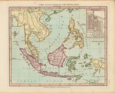
Title:
|
The east Indian archipelago
|
|
Original Title:
|
The east Indian archipelago
|
|
Contributor:
|
Luffman, J. (John), 1756-1846
|
|
Category:
|
General Maps
|
|
Type:
|
Printed
|
|
Language:
|
English
|
|
Create Year:
|
1812
|
|
Format:
|
JPEG, 6395 × 5176, 36.7MB
|
|
Scale:
|
Scale not given
|
|
Physical Map Dimension (cm):
|
21 x 26
|
|
Note:
|
Macao and the surrounding islands were depicted in this map.
|
|
Note:
|
Macao in East Indies Maps
|
|
Geographic Area:
|
Indonesia
|
|
Geographic Area:
|
Southeast Asia
|
|
Pub Title:
|
Luffman’s geographical & topographical atlas : consisting of maps of countries, plans of cities and forts, ports and harbours, battles &c.
|
|
Pub Author:
|
Luffman, J. (John), 1756-1846
|
|
Pub Year:
|
ca. 1816?
|
|
Pub location:
|
London
|
|
Provenance:
|
Houghton Library - Harvard College Library
|
|
MUST holding:
|
http://10.20.100.239/record=b1388902
|