Detail View: Old Maps Collection: Central Atlantic Ocean
|
Barcode:
|
4687820500967
|
|
Title:
|
Central Atlantic Ocean
|
|
Original Title:
|
[Océan Atlantique central]
|
|
Other Title:
|
Atlas of the Duchess de Berry
|
|
Contributor:
|
Albernaz, João Teixeira, fl. 1602-1649, cartographer
|
|
Contributor:
|
Berry, Marie-Caroline de Bourbon-Sicile, duchesse de, 1798-1870, former owner
|
|
Contributor:
|
Aunay, Jean-Charles de Mesgrigny d', comte, 1680-1763, former owner
|
|
Category:
|
Sea Charts
|
|
Type:
|
Manuscripts
|
|
Language:
|
Portuguese
|
|
Create Year:
|
[ca. 1628]
|
|
Format:
|
JPEG 2000, 4752 x 3303, 25MB
|
|
Page No.:
|
7
|
|
Scale:
|
Scale indeterminable.
|
|
Physical Map Dimension (cm):
|
27 x 39 cm, on sheet 30 x 44 cm
|
|
Note:
|
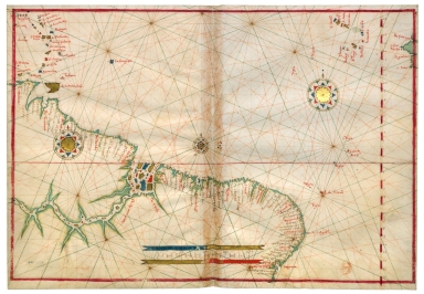
This is an anonymous atlas under the assigned title 'Atlas nautique du monde'. It is attributed to João Albernaz Teixeira and dated around 1628 by Armando Cortesão after analyzing all the charts and comparing it with other works by the same author. The original atlas has two ex libris, one of Jean-Charles de Mesgrigny and the other of the Duchesse de Berry. This chart depicts Brazil with Cape Verde islands.
|
|
Note:
|
Original is map from an atlas of 20 charts on parchment by João Teixeira Albernaz, 27 x 28 cm.
|
|
Note:
|
Title from provenance library.
|
|
Note:
|
There are three 32-point compass roses with an arrow indicating north, colored red, blue, green and gold. The rhumb lines for the principal winds are black, for the half winds green and the quarter winds red.
|
|
Note:
|
Table of leagues inside red, blue and gold cartouche.
|
|
Note:
|
Latitude line on the right side in red and white interchangeably.
|
|
Note:
|
Landmasses outlined in green with islands colored red, blue and gold.
|
|
Note:
|
Equator line colored red.
|
|
Note:
|
Map outlined in red border.
|
|
Note:
|
Place names written both in black and red.
|
|
Reference:
|
Cortesão, A. Portugaliae Monumenta Cartographica, vol. 4, p. 107-110
|
|
Reference:
|
Foncin, M. Catalogue des cartes nautiques sur vélin conservées au Département des cartes et plans, nº 82
|
|
Reference:
|
Pflederer, R.L. Census of Portolan Charts & Atlases: as reported and listed by the noted scholars of the genre in their works ranging from 1897 to 2008, p. 56
|
|
Subject:
|
World -- Maps
|
|
Subject:
|
Atlantic Ocean -- Maps
|
|
Geographic Area:
|
World
|
|
Geographic Area:
|
Atlantic Ocean
|
|
Geographic Area:
|
Cape Verde
|
|
Geographic Area:
|
Brazil
|
|
Relation Note:
|
[7]
|
|
Pub Title:
|
[Atlas nautique du monde]
|
|
Pub Author:
|
Albernaz, João Teixeira, fl. 1602-1649
|
|
Pub Year:
|
[ca. 1628]
|
|
Pub location:
|
[S.l.]
|
|
Provenance:
|
Bibliothèque Nationale de France
|
|
Provenance:
|
https://catalogue.bnf.fr/ark:/12148/cb40780659n
|
|
Provenance Call No.:
|
GE FF-14409 (RES)
|
|
MUST holding:
|
https://must.primo.exlibrisgroup.com/permalink/853MUST_INST/reglfj/alma991002991849805076
|