Detail View: Old Maps Collection: Kouang-tcheou-fou.
|
Barcode:
|
4687820500952
|
|
Title:
|
Kouang-tcheou-fou.
|
|
Original Title:
|
Province de Kouang-toung : treize feuilles de cartes particulières formant 2 grandes feuilles
|
|
Contributor:
|
Klaproth, Julius von, 1783-1835, cartographer
|
|
Category:
|
General Maps
|
|
Type:
|
Manuscripts
|
|
Language:
|
French
|
|
Create Year:
|
[ca. 1831]
|
|
Format:
|
JPEG 2000, 3642 x 2857, 14MB
|
|
Page No.:
|
1
|
|
Scale:
|
Scale not given.
|
|
Physical Map Dimension (cm):
|
23 x 23 cm, on sheet 24 x 31 cm
|
|
Note:
|
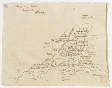
This is a map of the Guangdong Province divided into 13 sheets of 10 Fu (Fou) -larger prefectures- and 3 Zhou (Tcheou) -smaller prefectures. The names on the map are after the Cantonese pronunciation rather than the most common Mandarin pronunciation. Each sheet is fairly detailed with the location of rivers and mountains, the latter usually named. The land borders of each Fu are marked by a dotted line and have identified the unit with which borders. The main Fu of each sheet is marked with a big square, the Zhou with a double diamond and the Xian (Hian) -counties- with a double circle.
|
|
Note:
|
Original is a manuscript map in various formats, in a 25 x 32 cm envelope.
|
|
Note:
|
Title from provenance library.
|
|
Note:
|
Relief shown pictorially.
|
|
Note:
|
Macao in China maps.
|
|
Note:
|
Macao and its surroundings.
|
|
Geographic Area:
|
Guangdong Sheng (China)
|
|
Relation Note:
|
1.e feuille
|
|
Pub Title:
|
Province de Kouang-toung : treize feuilles de cartes particulières formant 2 grandes feuilles
|
|
Pub Author:
|
Klaproth, Julius von, 1783-1835
|
|
Pub Year:
|
[ca. 1831]
|
|
Pub location:
|
[S.l.]
|
|
Provenance:
|
Bibliothèque Nationale de France
|
|
Provenance:
|
https://catalogue.bnf.fr/ark:/12148/cb42046844v
|
|
Provenance Call No.:
|
GE DD-2816 (13, 1-13 RES)
|
|
MUST holding:
|
https://must.primo.exlibrisgroup.com/permalink/853MUST_INST/171sgkf/alma991002992949605076
|