Detail View: Old Maps Collection: Abbregé de la carte de la Chine du R.P. Bouyn, Jesuiste
|
Barcode:
|
36878003545039
|
|
Title:
|
Abbregé de la carte de la Chine du R.P. Bouyn, Jesuiste
|
|
Original Title:
|
Abbregé de la carte de la Chine du R.P. Bouyn, Iesuiste
|
|
Contributor:
|
Sanson, Guillaume, 1633-1703, cartographer
|
|
Contributor:
|
Boym, Michal, 1612-1659, bibliographic antecedent
|
|
Contributor:
|
Mariette, Pierre, 1634-1716, printer
|
|
Category:
|
General Maps
|
|
Type:
|
Printed
|
|
Language:
|
French
|
|
Language:
|
Latin
|
|
Create Year:
|
1670
|
|
Format:
|
JPEG 2000, 3288 x 2995, 17MB
|
|
Scale:
|
Scale not given.
|
|
Physical Map Dimension (cm):
|
22 x 25 cm, on sheet 31 x 33 cm
|
|
Note:
|
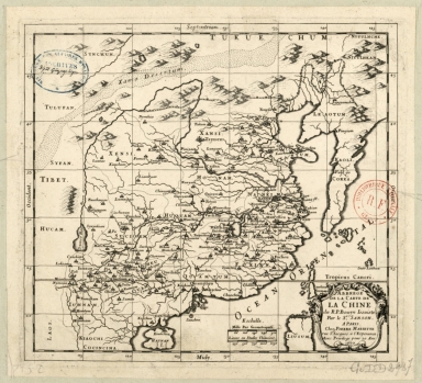
The source of the map, as stated by the title, was the Polish Jesuit missionary Michal Piotr Boym. He was one of the first westerners to travel within China Mainland, and the author of numerous works on Asian fauna, flora and geography. During his return trip to Europe he prepared a large collection of maps of China and South-East Asia. The merit of Boym's maps was that they were one of the first European maps to properly represent Korea as a peninsula, rather than an island, although extending too far south. A small northern part of the Philippine Island of Luzon can be seen on the bottom part of the map. He also took notice of the correct positions of many Chinese cities previously unknown to westerners. Boym also marked the Great Wall and the Gobi Desert (Xamo Desertum). He prepared a collection of maps with the intent of producing an atlas, but his work was never published during his lifetime but it extended the knowledge of China in the West. Nicholas Sanson over the course of his career produced over 300 maps, he was born in Abbeville in Picardy. Upon moving to Paris, he gained the attention of Cardinal Richelieu, who made an introduction of Sanson to King Louis XIII leading to Sanson's tutoring of the king. His success can be chalked up to his geographic and research skills, but also to his partnership with Pierre Mariette with whom he worked up until 1657. The depiction of the Great Wall is rather accurate and quite a number of toponyms can be seen on Mainland China even though Korea is blank denoting the lack of knowledge the westerners had of the country.
|
|
Note:
|
Original is a copperplate printed, 25 x 27 cm.
|
|
Note:
|
Title inside scrollwork cartouche on the right bottom corner of the map.
|
|
Note:
|
Double scale line in black and white interchangeably, on the left side of the title cartouche.
|
|
Note:
|
Relief shown pictorially.
|
|
Note:
|
Tropic of Cancer in double fillet.
|
|
Note:
|
Map with graticule.
|
|
Note:
|
The four borders of the map with latitude and longitude lines in black and white interchangeably. And labelled with North, South, East and West in Latin Septentrion. (Septentriones), Midy, Occident. and Orient. respectively.
|
|
Note:
|
Map outlined in simple fillet.
|
|
Note:
|
Macao in China maps.
|
|
Note:
|
Title and scale in French with Cardinal points, notes and Tropic line in Latin.
|
|
Reference:
|
Szcześniak, B. The Seventeenth Century Maps of China. An Inquiry into the Compilations of European Cartographers, In Imago Mundi, vol. 13 (1956), pp. 116-136
|
|
Subject:
|
Administrative and political divisions
|
|
Geographic Area:
|
China
|
|
Geographic Area:
|
Taiwan
|
|
Geographic Area:
|
Hainan Island (China)
|
|
Geographic Area:
|
Korea
|
|
Geographic Area:
|
Philippines
|
|
Provenance:
|
Bibliothèque Nationale de France
|
|
Provenance:
|
https://catalogue.bnf.fr/ark:/12148/cb406662311
|
|
Provenance Call No.:
|
GE DD-2987 (7152)
|
|
MUST holding:
|
https://must.primo.exlibrisgroup.com/permalink/853MUST_INST/171sgkf/alma991003002049805076
|