Detail View: Old Maps Collection: Abbregé de la carte de la Chine du R.P. Michel Ruggiery Jesuiste
|
Barcode:
|
36878003545028
|
|
Title:
|
Abbregé de la carte de la Chine du R.P. Michel Ruggiery Jesuiste
|
|
Original Title:
|
Abbregé de la carte de la Chine du R.P. Michel Ruggiery Iesuiste
|
|
Contributor:
|
Sanson, Guillaume, 1633-1703, cartographer
|
|
Contributor:
|
Ruggieri, Michele, 1543-1607, bibliographic antecedent
|
|
Contributor:
|
Mariette, Pierre, 1634-1716, printer
|
|
Category:
|
General Maps
|
|
Type:
|
Printed
|
|
Language:
|
French
|
|
Language:
|
Latin
|
|
Language:
|
Spanish
|
|
Create Year:
|
1670
|
|
Format:
|
JPEG 2000, 3872 x 3136, 20MB
|
|
Scale:
|
Scale not given.
|
|
Physical Map Dimension (cm):
|
22 x 29 cm, on sheet 32 x 38 cm
|
|
Note:
|
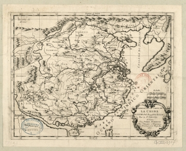
The source of the map, as stated by the title, was the Polish Jesuit missionary Michele Ruggieri. He was assigned to Macau to study the Chinese language and customs with the intent to settle somewhere in China, not just Macao. He obtained permission to establish a permanent mission within China in 1582. Two years later he published the first Chinese catechism and with Matteo Ricci as co-author, created a Portuguese-Chinese dictionary (the first ever European-Chinese dictionary). He is attributed one of the first collections of handwritten maps of China, translated into Latin from Chinese sources (atlases and maps), dating back to 1606, or nearly fifty years before the manuscript maps of the Polish Jesuit Michael Boym. The merit of his maps was that they were the first European maps to properly represent Korea as a peninsula, rather than an island, although curiously curved. A small northern part of the Philippine Island of Luzon (Isla de Luçon) can be seen on the bottom part of the map. He also marked the Great Wall and the Gobi Desert (Deserto de Arena). Nicholas Sanson over the course of his career produced over 300 maps, he was born in Abbeville in Picardy. Upon moving to Paris, he gained the attention of Cardinal Richelieu, who made an introduction of Sanson to King Louis XIII leading to Sanson's tutoring of the king. His success can be chalked up to his geographic and research skills, but also to his partnership with Pierre Mariette with whom he worked up until 1657. The depiction of the Great Wall is rather accurate and quite a number of toponyms can be seen on Mainland China even though Korea is blank denoting the lack of knowledge the westerners had of the country. Part of Japan can be seen on the right border of the map with the island of Kyushu (Bungo).
|
|
Note:
|
Original is a copperplate printed, 25 x 32 cm.
|
|
Note:
|
Title inside scrollwork cartouche on the right bottom corner of the map.
|
|
Note:
|
Double scale line in black and white interchangeably, on top of the title cartouche.
|
|
Note:
|
Relief shown pictorially.
|
|
Note:
|
Tropic of Cancer in double fillet.
|
|
Note:
|
Map with graticule.
|
|
Note:
|
The four borders of the map with latitude and longitude lines in black and white interchangeably. And labelled with North, South, East and West in Latin Septentrion. (Septentriones), Midy, Occident. and Orient. respectively.
|
|
Note:
|
Map outlined in simple fillet.
|
|
Note:
|
Macao in China maps.
|
|
Note:
|
Title and scale in French with Cardinal points, notes and Tropic line in Latin and some place names in Spanish.
|
|
Reference:
|
Szcześniak, B. The Seventeenth Century Maps of China. An Inquiry into the Compilations of European Cartographers, In Imago Mundi, vol. 13 (1956), pp. 116-136
|
|
Subject:
|
Administrative and political divisions
|
|
Geographic Area:
|
China
|
|
Geographic Area:
|
Taiwan
|
|
Geographic Area:
|
Hainan Island (China)
|
|
Geographic Area:
|
Korea
|
|
Geographic Area:
|
Japan
|
|
Geographic Area:
|
Philippines
|
|
Provenance:
|
Bibliothèque Nationale de France
|
|
Provenance:
|
https://catalogue.bnf.fr/ark:/12148/cb40666230p
|
|
Provenance Call No.:
|
GE DD-2987 (7151)
|
|
MUST holding:
|
https://must.primo.exlibrisgroup.com/permalink/853MUST_INST/171sgkf/alma991003002049705076
|