Detail View: Old Maps Collection: The city of Nagasaki and Dejima Island in Japan
|
Barcode:
|
4687820500075
|
|
Title:
|
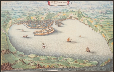
The city of Nagasaki and Dejima Island in Japan
|
|
Original Title:
|
[De Stadt Nangasacky] met het Eylandt Schissima, in Iapon
|
|
Contributor:
|
Vinckeboons, Joan
|
|
Category:
|
City Plans & Views
|
|
Type:
|
Printed
|
|
Language:
|
Dutch
|
|
Create Year:
|
1668
|
|
Format:
|
JPEG, 7875 x 5000, 18.3MB
|
|
Scale:
|
Scale not given
|
|
Note:
|
Dejima [meaning Exit] was an artificial island [completed in 1636] built in the shape of a fan with an area of about 13,000 square meters. It was built south of the current [Nagasaki] city center during the Edo Period in order to accommodate Portuguese Christian missionaries and prevent the propagation of their religion. It also used to be the residential quarters of the Dutch, the only foreigners allowed to trade in Japan during the Sakoku (Isolation) Period, and a Dutch Trading House operated on the island. For 200 years, until Japan reopened the country in the 19th century, Dejima was its only window to the world.
|
|
Subject:
|
Trading posts
|
|
Geographic Area:
|
Nagasaki-ken (Japan)
|
|
Geographic Area:
|
Deshima (Nagasaki-shi, Japan)
|
|
Relation Note:
|
In: Atlas Blaeu-Van der Hem, Bd. 41:24, fol. 96 - 97, (26)
|
|
Pub Title:
|
The Atlas Blaeu-Van der Hem : a facsimile-edition of the unique copy preserved in the Austrian National Library, Vienna.
|
|
Pub Author:
|
Blaeu, Joan, 1596-1673
|
|
Pub Year:
|
2009
|
|
Pub location:
|
't Goy-Houten
|
|
Provenance:
|
|