Detail View: Old Maps Collection: Plan de la ville et port de Macao
|
Barcode:
|
4687820500948
|
|
Title:
|
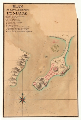
Plan de la ville et port de Macao
|
|
Category:
|
Topographic Maps
|
|
Type:
|
Manuscripts
|
|
Language:
|
French
|
|
Create Year:
|
[17--]
|
|
Format:
|
JPEG2000, 2960 x 4332, 38.3MB
|
|
Scale:
|
Scale not given.
|
|
Physical Map Dimension (cm):
|
36 x 24 cm
|
|
Note:
|
The map depicts a stylized built-up area typical of a plan. It has a legend on the left upper corner underneath the title that identifies 10 toponyms. The Border Gate; the Green Island as being used by the Jesuits; the Chinese village Wangxia -here unnamed-; the A-Ma Temple -named only as 'Pagode Chinoise'. However the most detail is given to military information such as where the vessels are built in Wanzai; the location of the harbours; the major fortification of the Monte -here named Nossa Senhora de Monte-; the Barra fortress -named S.t Iago & S.t Philippe-; the Penha fortress -N.ª S.ra de Penha-; the bastion of N.ª S.ra do Bomparto and the Guia fort -N.ª S.ra de Guia- where a lighthouse was built some years later.
|
|
Note:
|
Original is a colored manuscript map, 26 x 35 cm.
|
|
Note:
|
The buildings on the map are colored pink with trees colored green. All land masses outlined in green.
|
|
Note:
|
There is an 16-point compass rose on the left bottom corner of the map with a fleur de lis indicating north. It is colored red, blue and gold and the rhumb lines for the half-winds is dash-dotted.
|
|
Note:
|
Relief shown pictorially and by hachures.
|
|
Note:
|
The map has a pencil graticule.
|
|
Note:
|
Map outlined in double fillet.
|
|
Note:
|
City Plans of Macao.
|
|
Subject:
|
Macao (China) -- Maps
|
|
Geographic Area:
|
Macao (China)
|
|
Provenance:
|
Bibliothèque Nationale de France
|
|
Provenance:
|
https://catalogue.bnf.fr/ark:/12148/cb45081521d
|
|
Provenance Call No.:
|
GE SH 18 PF 179 DIV 12 P 2 D
|
|
MUST holding:
|
https://must.primo.exlibrisgroup.com/permalink/853MUST_INST/171sgkf/alma991002944049205076
|