Detail View: Old Maps Collection: Carte du port de Goa et ses environs
|
Barcode:
|
4687820500123
|
|
Title:
|
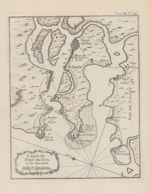
Carte du port de Goa et ses environs
|
|
Contributor:
|
Bellin, Jacques-Nicolas, 1703-1772, cartographer
|
|
Category:
|
Sea Charts
|
|
Type:
|
Printed
|
|
Language:
|
French
|
|
Create Year:
|
]1764]
|
|
Format:
|
JPEG 4847 × 5896, 31.7MB
|
|
Page No.:
|
29
|
|
Scale:
|
Scale indeterminable.
|
|
Physical Map Dimension (cm):
|
21 x 17 cm, on sheet 28 x 22 cm
|
|
Note:
|
This map depicts the harbor of Goa, India, most probably with a military purpose. The spotlight on the map seems to be given to harbors, with 7 marked, and forts, settlements, churches and other major buildings. As it is the case of the house of the Portuguese Viceroy of Goa.
|
|
Note:
|
Original is a copperplate printed map in the 'Le petit atlas maritime: recueil de cartes et plans des quatre parties du monde'.
|
|
Note:
|
There is a 16-point compass rose on the map with a fleur-de-lis indicating north. Rhumb lines for the principal winds are bold and half-winds are dotted.
|
|
Note:
|
Map oriented with East at the top.
|
|
Note:
|
Title inside scroll work cartouche.
|
|
Note:
|
Scale line underneath the title in black and white interchangeably.
|
|
Note:
|
Relief shown pictorially.
|
|
Note:
|
Map outlined in double fillet.
|
|
Reference:
|
Phillips, P.L. A list of geographical atlases in the Library of Congress, vol. 3, n.º 3508, p. 348-355
|
|
Geographic Area:
|
Velha Goa (India)
|
|
Geographic Area:
|
India
|
|
Relation Note:
|
Tome III, n.º 29
|
|
Pub Title:
|
Petit atlas maritime : recueil de cartes et plans des quatre parties du monde.
|
|
Pub Author:
|
Bellin, Jacques-Nicolas, 1703-1772
|
|
Pub Year:
|
1764
|
|
Pub location:
|
[Paris]
|
|
Provenance:
|
Harvard College Library
|
|
Provenance:
|
http://id.lib.harvard.edu/alma/990040126040203941/catalog
|
|
Provenance Call No.:
|
G1059 .B45 1764*.
|
|
MUST holding:
|
https://must.primo.exlibrisgroup.com/permalink/853MUST_INST/171sgkf/alma991002995549505076
|