Detail View: Old Maps Collection: 中華沿海形勢全圖. 澳門地區圖
|
Barcode:
|
4687820500068
|
|
Title:
|
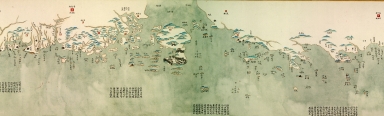
中華沿海形勢全圖. 澳門地區圖
|
|
Original Title:
|
中華沿海形勢全圖. 澳門地區圖
|
|
Contributor:
|
Anonymous
|
|
Category:
|
Sea Charts
|
|
Type:
|
Manuscripts
|
|
Language:
|
Chinese
|
|
Create Year:
|
1774-1795
|
|
Format:
|
JPEG, 11574 × 3519, 19.8MB
|
|
Scale:
|
ca. 1:760,000
|
|
Physical Map Dimension (cm):
|
29 x 908
|
|
Note:
|
這幅古地圖繪製於1774至1795年間,全圖為彩色長卷,自北向南連續表現盛京、直隸、山東、江蘇、浙江、福建、廣東沿海的山川、島嶼、沙洲、港灣,並以文字標注了有關海防、航道、水情等情況. 此圖截自中華沿海形勢全圖的澳門地圖部份.
|
|
Subject:
|
Coasts
|
|
Subject:
|
Coast defenses
|
|
Geographic Area:
|
Guangdong Sheng (China)
|
|
Geographic Area:
|
Macao (China)
|
|
Pub Title:
|
中華沿海形勢全圖
|
|
Pub Author:
|
Anonymous
|
|
Pub Year:
|
1774-1795
|
|
Pub location:
|
[China]
|
|
Provenance:
|
Peking University Library
|
|
MUST holding:
|
http://10.20.100.239/record=b1407563
|