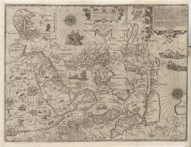
Detail View: Old Maps Collection: The Nauigation of the Portingales into the East Indies, containing their trauels by Sea, into East India, and from the East Indies into Portingall, also from the Portingall Indies to Malacca, China, Iapon, the Islands of Iaua and Sunda ...
|
Barcode:
|
4687820500108
|
|
Title:
|
The Nauigation of the Portingales into the East Indies, containing their trauels by Sea, into East India, and from the East Indies into Portingall, also from the Portingall Indies to Malacca, China, Iapon, the Islands of Iaua and Sunda ...
|
|
Original Title:
|
The Nauigation of the Portingales into the East Indies, containing their trauels by Sea, into East India, and from the East Indies into Portingall, also from the Portingall Indies to Malacca, China, Iapon, the Islands of Iaua and Sunda ...
|
|
Contributor:
|
Wolfe, John
|
|
Contributor:
|
Phillip, William
|
|
Contributor:
|
Linschoten, Jan Huygen van, 1563-1611
|
|
Category:
|
Sea Charts
|
|
Type:
|
Printed
|
|
Language:
|
Latin
|
|
Create Year:
|
1598
|
|
Format:
|
JPEG, 9496 × 7424, 70.8MB
|
|
Scale:
|
Scale not given
|
|
Note:
|
Macao in Routes
|
|
Note:
|
Macao and its Surroundings
|
|
Subject:
|
Voyages and travels
|
|
Geographic Area:
|
South China Sea
|
|
Geographic Area:
|
China
|
|
Geographic Area:
|
Japan
|
|
Geographic Area:
|
Korea
|
|
Geographic Area:
|
Philippines
|
|
Geographic Area:
|
Malay Archipelago
|
|
Geographic Area:
|
Strait of Malacca
|
|
Pub Title:
|
Discours of Voyages into ye Easte & West Indies
|
|
Pub Author:
|
Linschoten, Jan Huygen van, 1563-1611
|
|
Pub Year:
|
[1598]
|
|
Pub location:
|
London
|
|
Provenance:
|
Houghton Library - Harvard College Library
|
|
MUST holding:
|
http://10.20.100.239/record=b1347351
|