Detail View: Old Maps Collection:
|
Barcode:
|
3687800354097H
|
|
Original Title:
|
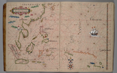
[Southern portion of east coast of Asia, part of East Indies]
|
|
Category:
|
Sea Charts
|
|
Type:
|
Manuscripts
|
|
Language:
|
Portuguese
|
|
Create Year:
|
[ca. 1630]
|
|
Format:
|
JPEG 2000, 7072 × 5120, 25.2MB
|
|
Page No.:
|
68
|
|
Scale:
|
Scale not given.
|
|
Physical Map Dimension (cm):
|
40 x 62 cm, on sheet 44 x 67 cm
|
|
Note:
|
The Atlas of this chart was sold by the bookseller Bernard Quaritch (1819-1899) to Henry Huth (1815-78) in 1863. And in 1917 was acquired in auction by the Huntington Library. A very curious characteristic of this Atlas is that it seems to have been made in Macao, although some authors, including Cortesão, seem to disagree with this possibility. Even though it was not possible to find the author of the atlas, it shows conspicuous affinities with the works of Domingos Sanches (fl. 1618), António Sanches (fl. 1623-1641) and Pascoal Roiz (fl. 1632-1633). The chart, just like most of the other sheets of the atlas, have little to none topography. The outline of the landmasses is still very lacking and Papua New Guinea is only partly seen, as well as Australia, denoting the knowledge that land was there but had not been completely explored yet. The Atlas is not by far prime Portuguese cartography.
|
|
Note:
|
Original is a manuscript map from a Portuguese Atlas, 27 x 36 cm. On the last page there is a manuscript note: "De Gaspar Mĩz" [Martins?].
|
|
Note:
|
Title from provenance library.
|
|
Note:
|
There is a 32-point compass rose on the map with a fleur-de-lis indicating north, colored red, blue and gold. Rhumb lines for the principal winds in black, half-winds in green and quarter-winds in red. There is a drawing of a sail ship on the Pacific Ocean.
|
|
Note:
|
Table of leagues on the upper left corner of the map inside strapworks cartouche colored magenta, red, blue and gold.
|
|
Note:
|
Relief shown pictorially.
|
|
Note:
|
Latitude line on the right border of the map colored red, blue and gold interchangeably. Another one in magenta and white and another in green and white.
|
|
Note:
|
Landmasses outlined in green, magenta and yellow with small islands colored green, red, blue and gold.
|
|
Note:
|
Tropic of Cancer and Equator in red line.
|
|
Note:
|
Toponyms in red and black.
|
|
Note:
|
Macao in East Indies maps.
|
|
Reference:
|
Cortesão, A. Portugaliae monumenta cartographica, vol. 5, pp. 23-24
|
|
Reference:
|
Cortesão, A. Cartografia e cartógrafos portugueses dos séculos XV e XVI (Lisbon 1935), vol. 1, pp. 168-70
|
|
Reference:
|
De Ricci, S. Census of Medieval and Renaissance Manuscripts in the United States and Canada , 43.
|
|
Reference:
|
Wagner, H.R. "The Portolan Atlases of American Interest in the Henry E. Huntington Library and Art Gallery" in Essays offered to Herbert Putnam, 498-509
|
|
Subject:
|
Asia -- Maps
|
|
Geographic Area:
|
East Indies
|
|
Geographic Area:
|
Malaysia
|
|
Geographic Area:
|
Cambodia
|
|
Geographic Area:
|
Thailand
|
|
Geographic Area:
|
Vietnam
|
|
Geographic Area:
|
Paracel Islands
|
|
Geographic Area:
|
China
|
|
Geographic Area:
|
Indonesia
|
|
Geographic Area:
|
Borneo
|
|
Geographic Area:
|
Philippines
|
|
Geographic Area:
|
Taiwan
|
|
Geographic Area:
|
Japan
|
|
Relation Note:
|
[f. 67v-68]
|
|
Pub Title:
|
[Portolan atlas, Portuguese]
|
|
Pub Year:
|
[ca. 1625-1650]
|
|
Pub location:
|
[Macao]
|
|
Provenance:
|
Huntington Library Collection
|
|
Provenance:
|
https://catalog.huntington.org/record=b1862013
|
|
Provenance Call No.:
|
mssHM 39
|
|
MUST holding:
|
https://must.primo.exlibrisgroup.com/permalink/853MUST_INST/171sgkf/alma991002923848105076
|